Pando, Uruguay

Last updated
Pando
City & Municipality
Plaza de Pando.jpg
The central square of Pando with the Church of the Immaculate Conception in the background
Uruguay location map.svg
Red pog.svg
Pando
Location within Uruguay
Coordinates: 34°43′0″S55°57′30″W / 34.71667°S 55.95833°W / -34.71667; -55.95833
CountryFlag of Uruguay.svg  Uruguay
Department Flag of Canelones Department.svg  Canelones
Founded1788
Population
 (2011 Census)
  Total25,947
Time zone UTC -3
Postal code
91000
Dial plan +598 2 (+7 digits)
Location of Pando in Canelones Department CanelonesCiudadesPando.svg
Location of Pando in Canelones Department

Pando is a city in the Canelones Department of Uruguay. It is an important commercial and industrial centre which has become part of the wider Montevideo metropolitan area.

Contents

Pando is also the name of the municipality to which the city belongs and which includes several other small populated areas and rural areas from the limits of the Ciudad de la Costa to the south to the limits of Route 7 to the northwest.

Geography

The city is located on Route 8, about 29 kilometres (18 mi) northeast of Montevideo. The stream Arroyo Pando flows by the east limits of the city.

Climate

The climate in this area is characterized by hot, humid summers and generally mild to cool winters. According to the Köppen Climate Classification system, Pando has a humid subtropical climate, abbreviated "Cfa" on climate maps. [1]

Climate data for Pando, Uruguay
MonthJanFebMarAprMayJunJulAugSepOctNovDecYear
Average high °C (°F)28
(83)
28
(82)
26
(78)
22
(71)
18
(64)
15
(59)
14
(58)
15
(59)
17
(63)
20
(68)
23
(74)
26
(79)
21
(70)
Average low °C (°F)17
(62)
16
(61)
15
(59)
12
(53)
9
(48)
6
(43)
6
(43)
6
(43)
8
(46)
9
(49)
12
(54)
15
(59)
11
(52)
Average precipitation mm (inches)74
(2.9)
66
(2.6)
99
(3.9)
99
(3.9)
84
(3.3)
81
(3.2)
74
(2.9)
79
(3.1)
76
(3)
66
(2.6)
74
(2.9)
79
(3.1)
950
(37.4)
Source: Weatherbase [2]

History

Pando was founded on 13 May 1788. [3] It took its name from one of its first inhabitants who had moved there in 1730. It was the seat of the Guardia del Pando, a force against Portuguese advances. It had acquired the status of "Pueblo" (village) before the Independence of Uruguay.

According to the Act of Ley Nº 759, on 11 March 1863 it held the status of "Villa" (town). On 5 August 1920, its status was elevated to "Ciudad" (city) by the Act of Ley Nº 7.252. [3] At the time, it was an industrial center and had a track for airplanes which became an airport in 1928. This airport was moved to Carrasco in 1948 and the Military Aeronautic School took its place. [4]

In 1969, the Tupamaros took part in a violent occupation known as the Taking of Pando (Spanish : Toma de Pando). [5]

Places of worship

Population

According to the 2011 census, Pando had a population of 25,947. [7] In 2010, the Intendencia de Canelones had estimated a population of 31,713 for the municipality during the elections. [4]

YearPopulation
19087,927
196312,876
197516,406
198519,795
199623,384
200424,004
201125,947

Source: Instituto Nacional de Estadística de Uruguay [3]

Related Research Articles

<span class="mw-page-title-main">Canelones, Uruguay</span> Capital city & Municipality in Canelones, Uruguay

Canelones is the capital of the department of Canelones in Uruguay. Its name is derived from a species of cinnamon, which is called "canelón", growing along the banks of the homonymous river. Since 2010, the city is also the seat of the municipality of Canelones.

The Departamento de Canelones is one of the 19 Uruguayan departments. With an area of 4,536 km2 (1,751 sq mi) and 518,154 inhabitants, it is located in the south of Uruguay. Its capital is Canelones.

<span class="mw-page-title-main">Las Piedras, Uruguay</span> City and municipality in Canelones, Uruguay

Las Piedras is a city in the Canelones Department of Uruguay. As of the census of 2011, it is the seventh most populated city of the country.

<span class="mw-page-title-main">Tala, Uruguay</span> City & Municipality in Canelones, Uruguay

Tala is a town in the north of the Canelones Department of southern Uruguay.

<span class="mw-page-title-main">Ciudad de la Costa</span> City and Municipality in Canelones, Uruguay

Ciudad de la Costa is a city in Canelones Department of Uruguay, on the banks of the Río de la Plata between the streams Arroyo Carrasco and Arroyo Pando. It is considered an extension of the metropolitan area of Montevideo which it borders to the west, while to the east it borders Costa de Oro. It was declared a city on 19 October 1994 and given its current name. At the 2011 census, it was the second most populated city of Uruguay between Montevideo and Salto.

Progreso is a city in the Canelones Department of southern Uruguay.

La Paz is a small city in the Canelones Department, southern Uruguay.

<span class="mw-page-title-main">Santa Lucía, Uruguay</span> City & Municipality in Canelones, Uruguay

Santa Lucía is a city in the Canelones Department of southern Uruguay.

<span class="mw-page-title-main">San Ramón, Uruguay</span> City & Municipality in Canelones, Uruguay

San Ramón is a small city in the north of Canelones Department, in southern Uruguay.

<span class="mw-page-title-main">Aguas Corrientes</span> Town in Canelones Department, Uruguay

Aguas Corrientes is a small town in the Canelones Department of southern Uruguay. Its name is derived from the installations of pumping, filtration and purification of water from the Santa Lucia River, which is the largest in the country, supplying drinking water to the departments of Montevideo and Canelones.

<span class="mw-page-title-main">Barros Blancos</span> City in Canelones, Uruguay

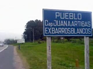
Barros Blancos is a city in the Canelones Department of southern Uruguay. In 1976, it had been renamed to Juan Antonio Artigas, after commanding officer Juan Antonio Artigas, grandfather of the national hero José Gervasio Artigas, but the old name was reinstated in 2007.

Dr. Francisco Soca or Soca is a small city in the Canelones Department of southern Uruguay.

<span class="mw-page-title-main">Empalme Olmos</span> Village in Canelones Department, Uruguay

Empalme Olmos is a village in the Canelones Department of southern Uruguay.

Migues is a small city in the Canelones Department of southern Uruguay.

<span class="mw-page-title-main">Cerrillos, Uruguay</span> City & Municipality in Canelones, Uruguay

Cerrillos or Los Cerrillos is a very small city in the west part of the Canelones Department of southern Uruguay.

<span class="mw-page-title-main">Salinas, Uruguay</span> City & Municipality in Canelones, Uruguay

Salinas is a city and resort of the Costa de Oro in the Canelones Department of southern Uruguay.

<span class="mw-page-title-main">San Jacinto, Uruguay</span> City & Municipality in Canelones, Uruguay

San Jacinto is a small city in the Canelones Department of southern Uruguay.

Santa Rosa is a small city in the Canelones Department of southern Uruguay.

Sauce is a small city and municipality in the Canelones Department of southern Uruguay.

Paso de Carrasco or Paso Carrasco is a city in the Canelones Department of Uruguay.

References

  1. Climate Summary for Pando, Uruguay
  2. "Weatherbase.com". Weatherbase. 2013. Retrieved on October 19, 2013.
  3. 1 2 3 "Statistics of urban localities (1908–2004)" (PDF). INE. 2012. Retrieved 8 September 2012.
  4. 1 2 "ELECCIONES - Canelones". El Observador. Archived from the original on 12 March 2012. Retrieved 2 February 2012.
  5. "Zabalza, su relato de la Toma de Pando y su encuentro con el hijo del civil asesinado". El Observador (in Spanish). 4 March 2020.
  6. Inmaculada Concepción de Pando (in Spanish)
  7. "Censos 2011 Cuadros Canelones". INE. 2012. Retrieved 25 August 2012.