
Humacao is a city and municipality in Puerto Rico located in the eastern coast of the island, north of Yabucoa; south of Naguabo; east of Las Piedras; and west of Vieques Passage. Humacao is spread over 12 barrios and Humacao Pueblo. It is part of the San Juan-Caguas-Guaynabo Metropolitan Statistical Area.
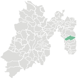
Coatepec Harinas is one of 125 municipalities in the State of Mexico, Mexico. The municipal seat is the town of Coatepec Harinas. The original name is "Coauhtepetl" which means 'serpent hill' in Náhuatl. Around 1825 because of a boom in flour production, the name "Harinas" was added.

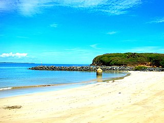
Yabucoa is a town and municipality in Puerto Rico located in the eastern region, north of Maunabo; south of San Lorenzo, Las Piedras and Humacao; and east of Patillas. Yabucoa is spread over 9 barrios and Yabucoa Pueblo. It is part of the San Juan-Caguas-Guaynabo Metropolitan Statistical Area.

Camuy is a town and municipality of Puerto Rico, bordering the Atlantic Ocean, north of Lares and San Sebastián; east of Quebradillas; and west of Hatillo. Camuy is spread over 12 barrios and Camuy Pueblo. The town celebrated its 200th anniversary in 2007.

Las Piedras is a town and municipality in east Puerto Rico (U.S.) located in the central eastern region of the island, north of Yabucoa; south of Canóvanas and Río Grande; east of Juncos and San Lorenzo; and west of Naguabo and Humacao. Las Piedras is spread over 7 barrios and Las Piedras Pueblo. It is part of the San Juan-Caguas-Guaynabo Metropolitan Statistical Area.
Toa Baja is a town and municipality of Puerto Rico located in the northern coast, north of Toa Alta and Bayamón; east of Dorado; and west of Cataño. Toa Baja is spread over five barrios, including Toa Baja Pueblo. Toa Baja is part of the San Juan-Caguas-Guaynabo Metropolitan Statistical Area. Toa Baja is located fifteen minutes by car from San Juan and two hours from Ponce.

Chiapas is a state in Southwest Mexico. According to the 2020 Mexican Census, it has the eighth largest population of all states with 5,543,828 inhabitants and the 10th largest by land area spanning 73,560.47 square kilometres (28,401.86 sq mi). Chiapas is officially divided into 124 municipalities, although the establishment of municipal authorities in Belisario Domínguez was suspended in 2015 pending the resolution of a territorial dispute between Chiapas and the neighbouring state of Oaxaca. In 2021, the Mexican Supreme Court resolved this dispute in Oaxaca's favour, and annulled the 2011 decree that had created Belisario Domínguez.

Fusagasugá or Fusa is a town and municipality in the department of Cundinamarca, in central Colombia. It is located in the warm valley between the rivers Cuja and Panches, a central region of the Andes Mountains in South America. The municipality has an estimated population of 134,523 as of 2015. The urban region has 108,157 inhabitants. The municipality itself covers an area of 206 km2 (80 sq mi).
Las Piedras is a city in the Canelones Department of Uruguay. As of the census of 2011, it is the fifth most populated city of the country.
Ixtapaluca is a city and a municipality in the eastern part of the State of Mexico in Mexico. It lies between the Federal District and the western border of the state of Puebla. The name Ixtapaluca means "Where the salt gets wet".

Ciudad Benito Juárez, or simply Juárez, is the name of a city located in the eastern part of the Monterrey metropolitan area in the state of Nuevo León, Mexico. It is the seat of the municipality of the same name. Ciudad Benito Juárez had a 2010 census population of 256,970 persons and is the eighth-largest city in Nuevo León. It shares borders with the municipalities of Pesquería to the north; to the south with Santiago; to the east with Cadereyta Jiménez; and to the west with Guadalupe.

San Juan Bautista Tuxtepec, or simply referred to as Tuxtepec, is the head of the municipality by the same name and is the second most populous city of the Mexican state of Oaxaca. It is part of the Tuxtepec District of the Papaloapan Region. As of the 2020 census, the city is home to a population of 103,609 and 159,452 in the municipality, though census data are often under reported for various reasons. The municipality resides in the region called La Cuenca, is located 36 feet above sea level, and occupies an area of approximately 580 square miles (1,500 km2). The city itself is surrounded by the Papaloapan River, and lies a few kilometers south of the Cerro de Oro Dam on its tributary the Santo Domingo River. The municipality is bordered by the state of Veracruz in the north, the municipalities of Loma Bonita to the east and San José Chiltepec to the south. It is almost 100 miles (160 km) to the port of Veracruz, 130 miles (210 km) to Oaxaca City, the state capital, and 310 miles (500 km) to Mexico City.

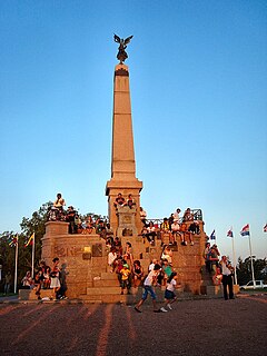
Santa Lucía is a city in the Canelones Department of southern Uruguay.
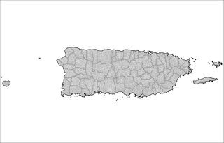
The barrios of Puerto Rico are the primary legal divisions of the seventy-eight municipalities of Puerto Rico. Each of Puerto Rico's 78 municipios are divided into geographical sections called barrios and as of 2010 there were 902.
Since 2009, the Uruguayan departments have been subdivided into municipalities. In the municipal elections of 2010 municipal authorities were elected for the first time and they assumed office months later. Currently there are 125 municipalities in Uruguay.
The 2015 Bolivian regional elections were held on 29 March 2015. Departmental and municipal authorities were elected by an electorate of approximately 6 million people. Among the officials elected were:

The Municipality of Maldonado is one of the eight municipalities of Maldonado Department, Uruguay. It was created by Law N° 18653 of 15 March 2010.

The municipality of Aguas Corrientes is one of the municipalities of Canelones Department, Uruguay, established on 15 March 2010. Its seat is the city of Aguas Corrientes.

The municipality of Río Branco is one of the municipalities of Cerro Largo Department, Uruguay, established on 13 September 2009. Its seat is the town of Río Branco. It replaced the Autonomous and Elective Local Board of Río Branco established in 1960.
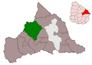
The municipality of Ramón Trigo is one of the municipalities of Cerro Largo Department, Uruguay, established on 3 April 2013. Its seat is the town of Ramón Trigo.


