San Luis, Uruguay

Last updated
San Luis
Village
Uruguay location map.svg
Red pog.svg
San Luis
Location in Uruguay
Coordinates: 34°46′0″S55°35′0″W / 34.76667°S 55.58333°W / -34.76667; -55.58333 Coordinates: 34°46′0″S55°35′0″W / 34.76667°S 55.58333°W / -34.76667; -55.58333
CountryFlag of Uruguay.svg  Uruguay
Department Canelones Department
Population
(2011)
  Total1,878
Time zone UTC -3
Postal code
16300
Dial plan +598 4378 (+4 digits)

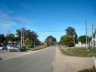
San Luis is a village and resort of Costa de Oro in the Canelones Department of southern Uruguay.

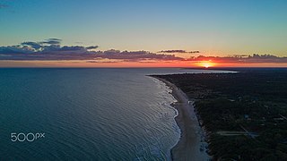
Costa de Oro is a 45 kilometres (28 mi) long group of resort towns and beaches in Canelones Department, Uruguay, east of the Ciudad de la Costa. Until 19 October 1994 it also included all the resorts that became henceforth integrated under the name Ciudad de la Costa. Since then, Costa de Oro contains only the resorts and locations of the area delimited by the streams Arroyo Pando to the west and Arroyo Solís Grande to the east and by the highways Ruta 8 and Ruta 9 to the north.

Canelones Department Place in Uruguay

The Departamento de Canelones , with an area of 4,536 km2 (1,751 sq mi) and 518,154 inhabitants, is located in the south of Uruguay. Its capital is Canelones.

Uruguay republic in South America

Uruguay, officially the Oriental Republic of Uruguay, is a country in the southeastern region of South America. It borders Argentina to its west and Brazil to its north and east, with the Río de la Plata to the south and the Atlantic Ocean to the southeast. Uruguay is home to an estimated 3.44 million people, of whom 1.8 million live in the metropolitan area of its capital and largest city, Montevideo. With an area of approximately 176,000 square kilometres (68,000 sq mi), Uruguay is geographically the second-smallest nation in South America, after Suriname.

Contents

Location

The village is located on Km. 63 of the Ruta Interbalnearia. It borders with the resorts Los Titanes to the east and Guazú - Virá to the west, with Arroyo del Bagre as the natural border with the later.

Ruta Interbalnearia highway in Uruguay

Ruta Interbalnearia or Ruta Líber Seregni is a national route of Uruguay. It connects Montevideo with Punta del Este to the east along the coast. The road is approximately 90 kilometres (56 mi) in length. It is marked on maps and signs as IB.

Los Titanes, Canelones human settlement

Los Titanes is a seaside resort in Canelones Department, Uruguay.

History

On 15 October 1963, its status was elevated to "Pueblo" (village) by the Act of Ley Nº 13.167. [1]

Population

In 2011 San Luis had a population of 1,878. [2]

YearPopulation
1963363
1975509
1985648
19961,180
20041,224
20111,878

Source: Instituto Nacional de Estadística de Uruguay [3]

Related Research Articles

Ismael Cortinas Town in Flores Department, Uruguay

Ismael Cortinas is a town in the Flores Department of Uruguay.

La Floresta, Uruguay City in Canelones Department, Uruguay

La Floresta is a city and resort on the Costa de Oro of the Canelones Department in Uruguay.

Tala, Uruguay City & Municipality in Canelones, Uruguay

Tala is a small city in the north of the Canelones Department of southern Uruguay.

Toledo, Uruguay City & Municipality in Canelones, Uruguay

Toledo is a small city in the Canelones Department of Uruguay. Together with Villa Crespo y San Andrés, it forms a population centre of more than 14,000, which is also generally known as "Toledo", although the censual area of Toledo itself has only about 4,400 inhabitants, according to the 2011 census. They are both part of the wider metropitan area of Montevideo.

Progreso, Uruguay City & Municipality in Canelones, Uruguay

Progreso is a city in the Canelones Department of southern Uruguay.

La Paz, Canelones City & Municipality in Canelones, Uruguay

La Paz is a small city in the Canelones Department, southern Uruguay.

San Ramón, Uruguay City & Municipality in Canelones, Uruguay

San Ramón is a small city in the north of Canelones Department, in southern Uruguay.

Barros Blancos City in Canelones, Uruguay

Barros Blancos is a city in the Canelones Department of southern Uruguay. In 1976, it had been renamed to Juan Antonio Artigas, after commanding officer Juan Antonio Artigas, grandfather of the national hero José Gervasio Artigas, but the old name was reinstated in 2007.

Empalme Olmos Village in Canelones Department, Uruguay

Empalme Olmos is a village in the Canelones Department of southern Uruguay.

Montes, Uruguay Village in Canelones Department, Uruguay

Montes is a village in the east of Canelones Department of southern Uruguay.

Cerrillos, Uruguay City & Municipality in Canelones, Uruguay

Cerrillos or Los Cerrillos is a very small city in the west part of the Canelones Department of southern Uruguay.

Salinas, Uruguay City & Municipality in Canelones, Uruguay

Salinas is a city and resort of the Costa de Oro in the Canelones Department of southern Uruguay.

San Bautista City & Municipality in Canelones, Uruguay

San Bautista is a small city in the Canelones Department of southern Uruguay.

San Jacinto, Uruguay City & Municipality in Canelones, Uruguay

San Jacinto is a small city in the Canelones Department of southern Uruguay.

Santa Rosa, Uruguay City & Municipality in Canelones, Uruguay

Santa Rosa is a small city in the Canelones Department of southern Uruguay.

San José de Carrasco Resort of Ciudad de la Costa in Canelones Department, Uruguay

San José de Carrasco is a residential neighbourhood and resort of Ciudad de la Costa in Canelones, Uruguay.

Ituzaingó, Uruguay Town in San José Department, Uruguay

Ituzaingó is a small town of San José Department of southern Uruguay.

Paso de Carrasco City & Municipality in Canelones, Uruguay

Paso de Carrasco or Paso Carrasco is a city in the Canelones Department of Uruguay.

Guazú-Virá human settlement

Guazuvirá or Guazú-Virá is a seaside resort in Canelones Department, Uruguay.

References

  1. "LEY N° 13.167". República Oriental del Uruguay, Poder Legislativo. 1963. Archived from the original on 16 February 2015. Retrieved 9 September 2012.
  2. "Censos 2011 Cuadros Canelones". INE. 2012. Retrieved 25 August 2012.
  3. "Statistics of urban localities (1963–2004)" (PDF). INE. 2012. Retrieved 9 September 2012.