The Arctic Archipelago, also known as the Canadian Arctic Archipelago, is an archipelago lying to the north of the Canadian continental mainland, excluding Greenland and Iceland.

The Mid-Atlantic Ridge is a mid-ocean ridge located along the floor of the Atlantic Ocean, and part of the longest mountain range in the world. In the North Atlantic, the ridge separates the North American from the Eurasian Plate and the African Plate, north and south of the Azores Triple Junction. In the South Atlantic, it separates the African and South American plates. The ridge extends from a junction with the Gakkel Ridge northeast of Greenland southward to the Bouvet Triple Junction in the South Atlantic. Although the Mid-Atlantic Ridge is mostly an underwater feature, portions of it have enough elevation to extend above sea level, for example in Iceland. The ridge has an average spreading rate of about 2.5 centimetres (1 in) per year.
New Berlin is a village in Chenango County, New York, United States. The population was 1,028 at the 2010 census. The village is by the eastern town line of the town of New Berlin and is northeast of Norwich.
The Reedy Glacier is a major glacier in Antarctica, over 100 nautical miles long and 6 to 12 nautical miles wide, descending from the polar plateau to the Ross Ice Shelf between the Michigan Plateau and Wisconsin Range in the Transantarctic Mountains. It marks the limits of the Queen Maud Mountains on the west and the Horlick Mountains on the east.

Shackleton Glacier is a major Antarctic glacier, over 60 nautical miles long and from 5 to 10 nautical miles wide, descending from the Antarctic Plateau from the vicinity of Roberts Massif and flowing north through the Queen Maud Mountains to enter the Ross Ice Shelf between Mount Speed and Waldron Spurs. Discovered by the United States Antarctic Service (USAS) (1939–41) and named by the Advisory Committee on Antarctic Names (US-ACAN) for Sir Ernest Shackleton, British Antarctic explorer.

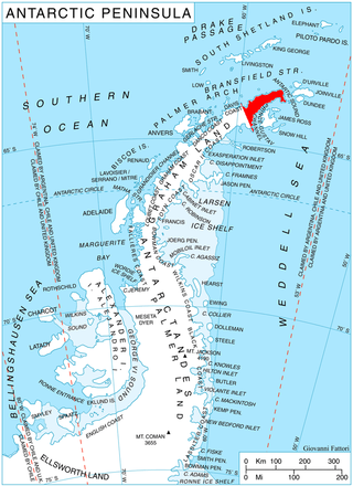
Trinity Peninsula is the northernmost part of the Antarctic Peninsula. It extends northeastward for about 130 km (80 mi) to Cape Dubouzet from an imaginary line connecting Cape Kater on the north-west coast and Cape Longing on the south-east coast. Prime Head is the northernmost point of this peninsula. Some 20 kilometers southeast of Prime Head is Hope Bay with the year-round Argentinian Esperanza Base.

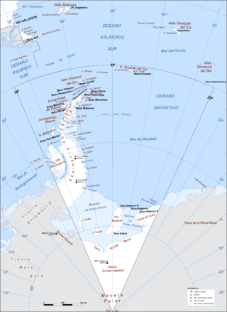
Argentine Antarctica is an area on Antarctica claimed by Argentina as part of its national territory. It consists of the Antarctic Peninsula and a triangular section extending to the South Pole, delimited by the 25° West and 74° West meridians and the 60° South parallel. This region overlaps with British and Chilean claims in Antarctica. None of these claims have widespread international recognition.

Cardeñajimeno is a municipality located in the province of Burgos, Castile and León, Spain. According to the 2004 census (INE), the municipality has a population of 612 inhabitants.
The Mariner Glacier is a major glacier over 60 nautical miles long, descending southeast from the plateau of Victoria Land, Antarctica, between Mountaineer Range and Malta Plateau, and terminating at Lady Newnes Bay, Ross Sea, where it forms the floating Mariner Glacier Tongue.
Bayly Glacier is a glacier flowing into the head of Bancroft Bay, on the west coast of Graham Land. It was mapped by the Falkland Islands Dependencies Survey (FIDS) from photos taken by Hunting Aerosurveys Ltd in 1956–57, and named by the UK Antarctic Place-Names Committee in 1960 for Maurice B. Bayly, FIDS geologist at the Danco Island station in 1956 who, together with L. Harris, pioneered the route from the Portal Point hut to the plateau in February 1957.
Watson Escarpment is a major escarpment in the Queen Maud Mountains, trending northward along the east margin of Scott Glacier, then eastward to Reedy Glacier where it turns southward along the glacier's west side. Somewhat arcuate, the escarpment is nearly 100 nautical miles long, rises 3,550 metres (11,650 ft) above sea level, and 1,000 to 1,500 metres above the adjacent terrain.
The Cumulus Hills are several groups of largely barren hills in Antarctica. Divided by the Logie Glacier, they are bounded by Shackleton Glacier on the west, McGregor Glacier on the north and Zaneveld Glacier on the south.
The Medina Peaks are rugged, mainly ice-free, peaks surmounting a ridge 15 nautical miles long, extending north along the east side of Goodale Glacier to the edge of the Ross Ice Shelf, Antarctica.
Starshot Glacier is a glacier 50 nautical miles (90 km) long that flows through the Churchill Mountains to enter the Ross Ice Shelf in Antarctica.
Hooper Glacier is a glacier 3 nautical miles (6 km) long, flowing from the col north of Mount William into the west side of Börgen Bay, Anvers Island, in the Palmer Archipelago, Antarctica. It was surveyed by the Falkland Islands Dependencies Survey (FIDS) in 1955, and named by the UK Antarctic Place-Names Committee for Peter R. Hooper of FIDS, leader and geologist at the Arthur Harbour station in 1955 and 1956. Gateway Ridge separates Hooper Glacier from William Glacier.
The Tomilin Glacier is a glacier over 15 nautical miles long, draining north from Pope Mountain in the central Wilson Hills. It enters the sea east of Goodman Hills and Cape Kinsey, forming a substantial glacier tongue.

Rush Glacier is a glacier in Antarctica. Situated in southern Brabant Island, it is 4 nautical miles (7 km) long, draining the northwest slopes of Solvay Mountains and flowing west between Mount Aciar and Mount Sarnegor into the Buragara Cove of Dallmann Bay in the Palmer Archipelago. It was shown on an Argentine government chart in 1953, but not named. It was photographed by Hunting Aerosurveys Ltd in 1956–57, and mapped from these photos in 1959. The glacier was named by the United Kingdom Antarctic Place-Names Committee (UK-APC) for Benjamin Rush (1745–1813), a noted American physician and philanthropist, and a signatory of the Declaration of Independence.
Little Murray River, a perennial stream of the Clarence River catchment, is located in the Northern Tablelands district of New South Wales, Australia.


