
The Peak District is an upland area in central-northern England, at the southern end of the Pennines. Mostly in Derbyshire, it extends into Cheshire, Greater Manchester, Staffordshire, West Yorkshire and South Yorkshire. It is subdivided into the Dark Peak, moorland dominated by gritstone, and the White Peak, a limestone area with valleys and gorges. The Dark Peak forms an arc on the north, east and west of the district, and the White Peak covers central and southern areas. The highest point is Kinder Scout. Most of the area is within the Peak District National Park, a protected landscape designated in 1951.

Eyam is an English village and civil parish in the Derbyshire Dales that lies within the Peak District National Park. There is evidence of early occupation by Ancient Britons on the surrounding moors and lead was mined in the area by the Romans. A settlement was founded on the present site by Anglo-Saxons, when mining was continued and other industries later developed. However, Eyam’s main claim to fame is the story of how the village chose to go into isolation so as to prevent infection spreading after bubonic plague was discovered there in 1665.

Derbyshire Dales is a local government district in Derbyshire, England. The district was created in 1974 as West Derbyshire; the name was changed to Derbyshire Dales in 1987. The council is based in the town of Matlock, and the district also includes the towns of Ashbourne, Bakewell, Darley Dale and Wirksworth, as well as numerous villages and extensive rural areas. Much of the district is within the Peak District National Park.

The Hope Valley is a rural area centred on the village of Hope, Derbyshire, in the Peak District in the northern Midlands of England.
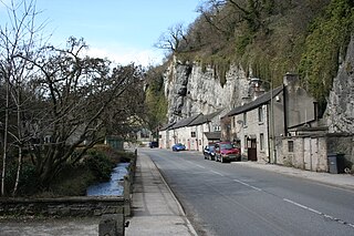
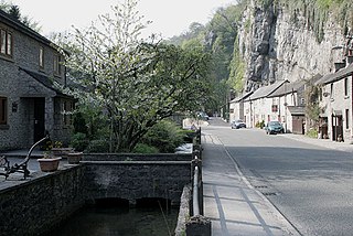
Stoney Middleton is a village and civil parish in the Derbyshire Dales district of Derbyshire, England. It is in the White Peak area of the Peak District southeast of Eyam and northwest of Calver, on the A623 road at the foot of the limestone valley of Middleton Dale. The population at the 2011 Census was 470.

William Mompesson was a Church of England priest whose decisive action when his Derbyshire parish, Eyam, became infected with the plague in the 17th century averted more widespread catastrophe.
The Roses of Eyam is a historical drama by Don Taylor about the Great Plague that swept Britain in 1665/66. It is largely based on the events that happened in the "plague village" of Eyam in Derbyshire, between September 1665 and December 1666. Published in 1970, The Roses of Eyam had its world premiere at The Northcott Theatre in Exeter, Devon, on 23 September 1970.
William Bagshaw or Bagshall (1628–1702) was an English presbyterian and nonconformist minister, known as the "Apostle of the Peak".
St Lawrence’s Church, Eyam is a Grade II* listed parish church in the Church of England in Eyam, Derbyshire.

Middleton Dale is a steep-sided, carboniferous limestone valley in the Derbyshire Peak District of England. The village of Stoney Middleton lies at the eastern foot of the dale and the village of Eyam lies about 600 metres (660 yd) to the north, through the side valley of Eyam Dale. The dale is cut into the surrounding gritstone uplands of Middleton Moor and Eyam Moor. Dale Brook stream runs down the dale into Stoke Brook and on into the River Derwent 1.5 kilometres (1 mi) beyond Stoney Middleton. The Delf is a secluded, wooded side gorge with a stream between Eyam and Middleton Dale. Opposite The Delf, water gushes from Hawkenedge Well and flows into Dale Brook.

The Derbyshire Dome is a geological formation across mid-Derbyshire in England.
The Hundreds of Derbyshire were the geographic divisions of the historic county of Derbyshire for administrative, military and judicial purposes. They were established in Derbyshire some time before the Norman conquest. In the Domesday Survey of 1086 AD the hundreds were called wapentakes. By 1273 the county was divided into 8 hundreds with some later combined, becoming 6 hundreds over the following centuries. The Local Government Act 1894 replaced hundreds with districts. Derbyshire is now divided into 8 administrative boroughs within the Derbyshire County Council area.
Hazlebadge is a civil parish within the Derbyshire Dales district, in the county of Derbyshire, England. Largely rural, Hazlebadge's population is reported with the population of neighbouring parishes for a total of 427 residents in 2011. It is 143 miles (230 km) north west of London, 29 miles (47 km) north west of the county city of Derby, and 7 miles (11 km) east of the nearest market town of Chapel-en-le-Frith. Hazlebadge is wholly within the Peak District national park, and shares a border with the parishes of Abney and Abney Grange, Bradwell, Brough and Shatton, Great Hucklow as well as Little Hucklow. There are four listed buildings in Hazlebadge.

Mompesson's Well is a 17th-century grade II listed water well in Eyam, Derbyshire.

Thomas Stanley was an ejected puritan minister whose actions alongside Church of England priest William Mompesson when the Derbyshire parish, Eyam, became infected with the plague during the 17th century averted more widespread catastrophe.
Shorland (or Sherland)Adams (c. 1605 – 11 Apr 1664) was a Church of England priest whose outspoken support for the Royalists during the English Civil War garnished his reputation during his tenure in the parishes of Eyam and Treeton.

Jumber Brook is a stream in Eyam in the Derbyshire Peak District. The stream originates to the north of the village at Highcliffe. The brook flows south through the middle of the village before meeting the Dale Brook in Middleton Dale near Stoney Middleton.
Dale Brook is a stream in Stoney Middleton in the Derbyshire Peak District. The stream originates in Middleton Dale, where the Jumber Brook south of Eyam passes under the A623 becoming Dale Brook. The brook flows east through Stoney Middleton where it meets the Stoke Brook before joining the River Derwent at Calver.

Jumber Brook is a stream in Eyam in the Derbyshire Peak District. The stream originates to the north of the villiage between Abney and Leam. The brook flows south through the middle of the village before meeting the Dale Brook in Middleton Dale near Stoney Middleton.

