
The Peak District is an upland area in England, at the southern end of the Pennines. Mostly in Derbyshire, it extends into Cheshire, Greater Manchester, Staffordshire, West Yorkshire and South Yorkshire and includes the Dark Peak, moorland dominated by gritstone, and the White Peak, a limestone area with valleys and gorges. The Dark Peak forms an arc on the north, east and west sides; the White Peak covers central and southern tracts. The Peak District was the first of the national parks of England and Wales in 1951. The historic Peak District extends beyond the National Park, which excludes major towns, quarries and industrial areas. Nearby Manchester, Stoke-on-Trent, Derby and Sheffield send millions of visitors. Inhabited from the Mesolithic era, it shows evidence of the Neolithic, Bronze and Iron Ages. Settled by the Romans and Anglo-Saxons, it remained largely agricultural; mining arose in the Middle Ages. Richard Arkwright built cotton mills in the Industrial Revolution. As mining declined, quarrying grew. Tourism came with the railways, spurred by the landscape, spa towns and Castleton's show caves.

Eyam is an English village and civil parish in the Derbyshire Dales that lies within the Peak District National Park. There is evidence of early occupation by Ancient Britons on the surrounding moors and lead was mined in the area by the Romans. A settlement was founded on the present site by Anglo-Saxons, when mining was continued and other industries later developed. However, Eyam’s main claim to fame is the story of how the village chose to go into isolation so as to prevent infection spreading after bubonic plague was discovered there in 1665.

Derbyshire Dales is a local government district in Derbyshire, England. The district was created in 1974 as West Derbyshire; the name was changed to Derbyshire Dales in 1987. The council is based in the town of Matlock, and the district also includes the towns of Ashbourne, Bakewell, Darley Dale and Wirksworth, as well as numerous villages and extensive rural areas. Much of the district is within the Peak District National Park.

During the Great Plague of 1665 the area of Derby, England, fell victim to the bubonic plague epidemic, with many deaths. Some areas of Derby still carry names that record the 1665 visitation such as Blagreaves Lane which was Black Graves Lane, while Dead Man's Lane speaks for itself. It has been claimed by some historians that bodies were buried standing upright at St. Peter's Church, Derby, but this legend has been refuted by experts.

The Hope Valley is a rural area centred on the village of Hope, Derbyshire, in the Peak District in the northern Midlands of England.

Hathersage railway station serves the village of Hathersage in the Derbyshire Peak District, in England.

Chew Valley in Saddleworth, Greater Manchester, England, follows the course of Chew Brook on the western slopes of Black Chew Head to where it joins the River Tame at Greenfield, east of Manchester. Part of the higher fringes of the valley towards the peak of Black Chew Head lie across the boundary in Derbyshire. The eastern part of the valley including the reservoirs of Dovestone and Chew are within the north western extremity of the Peak District National Park.
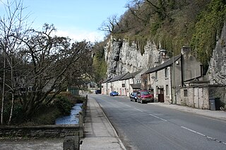
Stoney Middleton is a village and civil parish in the Derbyshire Dales district of Derbyshire, England. It is in the White Peak area of the Peak District southeast of Eyam and northwest of Calver, on the A623 road at the foot of the limestone valley of Middleton Dale. The population at the 2011 Census was 470.

William Mompesson was a Church of England priest whose decisive action when his Derbyshire parish, Eyam, became infected with the plague in the 17th century averted more widespread catastrophe.

Eyam Hall is a country house within the civil parish of Eyam, Derbyshire, located to the west of St Lawrence's Church, Eyam. It is recorded in the National Heritage List for England as a Grade II* listed building.

Eyam Museum or as it is locally known Eyam Plague museum is a local museum in the village of Eyam, located in the Peak District, Derbyshire, England.

Middleton Dale is a steep-sided, carboniferous limestone valley in the Derbyshire Peak District of England. The village of Stoney Middleton lies at the eastern foot of the dale and the village of Eyam lies about 600 metres (660 yd) to the north, through the side valley of Eyam Dale. The dale is cut into the surrounding gritstone uplands of Middleton Moor and Eyam Moor. Dale Brook stream runs down the dale into Stoke Brook and on into the River Derwent 1.5 kilometres (1 mi) beyond Stoney Middleton. The Delf is a secluded, wooded side gorge with a stream between Eyam and Middleton Dale. Opposite The Delf, water gushes from Hawkenedge Well and flows into Dale Brook.

The Derbyshire Dome is a geological formation across mid-Derbyshire in England.

Eyam Moor is a plateau-topped hill between the villages of Eyam and Hathersage in Derbyshire, in the Peak District of England. The summit of Sir William Hill is 429 metres (1,407 ft) above sea level.
The geology of the Peak District National Park in England is dominated by a thick succession of faulted and folded sedimentary rocks of Carboniferous age. The Peak District is often divided into a southerly White Peak where Carboniferous Limestone outcrops and a northerly Dark Peak where the overlying succession of sandstones and mudstones dominate the landscape. The scarp and dip slope landscape which characterises the Dark Peak also extends along the eastern and western margins of the park. Although older rocks are present at depth, the oldest rocks which are to be found at the surface in the national park are dolomitic limestones of the Woo Dale Limestone Formation seen where Woo Dale enters Wye Dale east of Buxton.

Bretton Brook is a stream flowing through Bretton in the Derbyshire Peak District. The stream is a tributary of the Highlow Brook, which is a direct tributary the River Derwent south of Hathersage.

Mompesson's Well is a 17th-century grade II listed water well in Eyam, Derbyshire.

Thomas Stanley was an ejected puritan minister whose actions alongside Church of England priest William Mompesson when the Derbyshire parish, Eyam, became infected with the plague during the 17th century averted more widespread catastrophe.
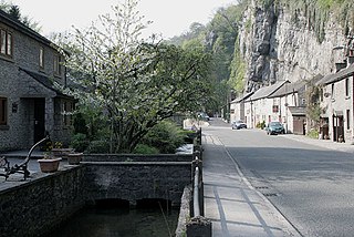
Dale Brook is a stream in Stoney Middleton in the Derbyshire Peak District. The stream originates in Middleton Dale, where the Jumber Brook south of Eyam passes under the A623 becoming Dale Brook. The brook flows east through Stoney Middleton where it meets the Stoke Brook before joining the River Derwent at Calver.

