
Derbyshire Dales is a local government district in Derbyshire, England. The district was created in 1974 as West Derbyshire; the name was changed to Derbyshire Dales in 1987. The council is based in the town of Matlock, and the district also includes the towns of Ashbourne, Bakewell, Darley Dale and Wirksworth, as well as numerous villages and extensive rural areas. Much of the district is within the Peak District National Park.

The Hope Valley is a rural area centred on the village of Hope, Derbyshire, in the Peak District in the northern Midlands of England.

The High Peak Trail is a 17-mile (27 km) trail for walkers, cyclists and horse riders in the Peak District of England. Running from Dowlow (53.2059°N 1.8349°W), near Buxton, to High Peak Junction, Cromford (53.1004°N 1.5354°W), it follows the trackbed of the former Cromford and High Peak Railway, which was completed in 1831 to carry minerals and goods between the Cromford Canal wharf at High Peak Junction and the Peak Forest Canal at Whaley Bridge.

The River Dove is the principal river of the southwestern Peak District, in the Midlands of England and is around 45 miles (72 km) in length. It rises on Axe Edge Moor near Buxton and flows generally south to its confluence with the River Trent at Newton Solney. From there, its waters reach the North Sea via the Humber Estuary. For almost its entire course it forms the boundary between the counties of Staffordshire and Derbyshire. The river meanders past Longnor and Hartington and cuts through a set of deep limestone gorges, Beresford Dale, Wolfscote Dale, Milldale and Dovedale.

Chew Valley in Saddleworth, Greater Manchester, England, follows the course of Chew Brook on the western slopes of Black Chew Head to where it joins the River Tame at Greenfield, east of Manchester. Part of the higher fringes of the valley towards the peak of Black Chew Head lie across the boundary in Derbyshire. The eastern part of the valley including the reservoirs of Dovestone and Chew are within the north western extremity of the Peak District National Park.
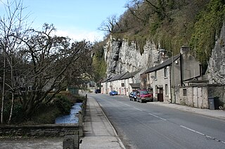
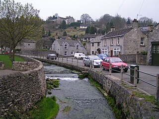
Stoney Middleton is a village and civil parish in the Derbyshire Dales district of Derbyshire, England. It is in the White Peak area of the Peak District southeast of Eyam and northwest of Calver, on the A623 road at the foot of the limestone valley of Middleton Dale. The population at the 2011 Census was 470.
Bentley Brook is a stream in Derbyshire, England. It rises on Matlock Moor, flowing south through Cuckoostone Dale, under the A632, into Lumsdale, gathering the valley's waters—notably from Knabhall Brook, out of Tansley, itself dammed and supporting large mills. In Lumsdale it enters a now disused mill pond or reservoir, then flows over a waterfall in the course of passing several historical mill ruins. Finally, it runs through control gates into the outside bend of a tight oxbow of the River Derwent, just beyond Hall Leys Park in Matlock. Although only about five miles in length, Bentley Brook is classed as a 'main river' by the Environment Agency.
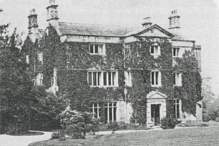
Whiteley Wood Hall was an English country house which was demolished in 1959. It stood off Common Lane in the Fulwood area of Sheffield, England. The hall’s stables and associated buildings are still standing and along with the surrounding grounds now serve as an outdoor activities centre for Girlguiding Sheffield. The stables are a Grade II listed building.

The River Bradford is a river in the Peak District National Park in Derbyshire. Its source is on Gratton Moor and after passing below Youlgreave it joins the River Lathkill at Alport. Less than 4 miles (7 km) in length, its waters are very clear due to the limestone rock over which it flows, and its width has been enhanced by a number of weirs which also encourage white-throated dippers to breed in the ponds created. The river is owned and managed by the Haddon Estate and is home to brown trout and white-clawed crayfish. The valley is known as Bradford Dale, and the Limestone Way passes through it.
The Derbyshire Dales National Nature Reserve is a series of unconnected limestone dales in the Peak District National Park. It is managed by Natural England and has a permanent staff of wardens who carry out conservation works and ensure the dales are usable for recreation.

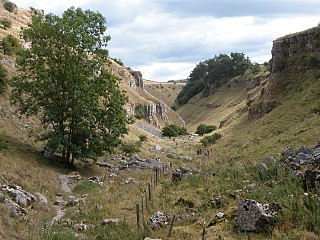
Coombs Dale is a steep-sided, dry carboniferous limestone valley in the Derbyshire Peak District of England. The village of Calver lies about 1 km to the east and the village of Stoney Middleton lies less than 1 km to the north. The dale is cut into the hills on the east side of Longstone Moor. The upper end of the dale is known as Rough Side. Several springs flow down the dale during winter and after heavy rains.

Middleton Dale is a steep-sided, carboniferous limestone valley in the Derbyshire Peak District of England. The village of Stoney Middleton lies at the eastern foot of the dale and the village of Eyam lies about 600 metres (660 yd) to the north, through the side valley of Eyam Dale. The dale is cut into the surrounding gritstone uplands of Middleton Moor and Eyam Moor. Dale Brook stream runs down the dale into Stoke Brook and on into the River Derwent 1.5 kilometres (1 mi) beyond Stoney Middleton. The Delf is a secluded, wooded side gorge with a stream between Eyam and Middleton Dale. Opposite The Delf, water gushes from Hawkenedge Well and flows into Dale Brook.

Hood Brook is a stream in the Derbyshire Peak District, originating near Stanage Edge, close to Robin Hoods Cave.
Bradwell Brook is a stream in the Derbyshire Peak District, originating in Bradwell, in a cave known as Bagshawe Resurgence.
Deadman's Clough is a stream in the civil parish of Hazlebadge in the Derbyshire Peak District. The stream rises to the south of Bradwell, where it meets the Bretton Brook to the west of Abney.

Highlow Brook is a stream in the civil parish of Highlow in the Derbyshire Peak District. The stream is a tributaries of the River Derwent, flowing southeast from the river, south of Hathersage, before meeting the Bretton Brook in Abney.

Bretton Brook is a stream flowing through Bretton in the Derbyshire Peak District. The stream is a tributary of the Highlow Brook, which is a direct tributary the River Derwent south of Hathersage.

Jumber Brook is a stream in Eyam in the Derbyshire Peak District. The stream originates to the north of the village at Highcliffe. The brook flows south through the middle of the village before meeting the Dale Brook in Middleton Dale near Stoney Middleton.

