
The Peak District is an upland area in England, at the southern end of the Pennines. Mostly in Derbyshire, it extends into Cheshire, Greater Manchester, Staffordshire, West Yorkshire and South Yorkshire and includes the Dark Peak, moorland dominated by gritstone, and the White Peak, a limestone area with valleys and gorges. The Dark Peak forms an arc on the north, east and west sides; the White Peak covers central and southern tracts. The Peak District was the first of the national parks of England and Wales in 1951. The historic Peak District extends beyond the National Park, which excludes major towns, quarries and industrial areas. Nearby Manchester, Stoke-on-Trent, Derby and Sheffield send millions of visitors. Inhabited from the Mesolithic era, it shows evidence of the Neolithic, Bronze and Iron Ages. Settled by the Romans and Anglo-Saxons, it remained largely agricultural; mining arose in the Middle Ages. Richard Arkwright built cotton mills in the Industrial Revolution. As mining declined, quarrying grew. Tourism came with the railways, spurred by the landscape, spa towns and Castleton's show caves.

Treak Cliff Cavern is a show cave near Castleton in Derbyshire, England. It is part of the Castleton Site of Special Scientific Interest and one of only two sites where the ornamental mineral Blue John is still excavated. As part of an agreement with English Nature, the Blue John that can be seen in the show cave is not mined but it is extracted in small quantities from other areas of the cave and made into saleable items like bowls, jewellery, and ornaments.

Carboniferous Limestone is a collective term for the succession of limestones occurring widely throughout Great Britain and Ireland that were deposited during the Dinantian Epoch of the Carboniferous Period. These rocks formed between 363 and 325 million years ago. Within England and Wales, the entire limestone succession, which includes subordinate mudstones and some thin sandstones, is known as the Carboniferous Limestone Supergroup.
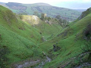
Cave Dale is a dry limestone valley in the Derbyshire Peak District, England. It is located at grid reference SK149824. The northern end of the dale starts at the village of Castleton where the valley sides are almost perpendicular and over 50 metres (160 ft) in height. The dale rises gently after leaving Castleton for approximately 200 metres (220 yd) before becoming steeper culminating in a fine viewpoint down the dale taking in Peveril Castle with Lose Hill behind. After the viewpoint the dale swings west and levels out with gentle gradients, becoming just a shallow depression as it peters out onto the open pastureland between Castleton and Chapel-en-le-Frith.
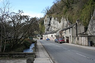
Stoney Middleton is a village and civil parish in the Derbyshire Dales district of Derbyshire, England. It is in the White Peak area of the Peak District southeast of Eyam and northwest of Calver, on the A623 road at the foot of the limestone valley of Middleton Dale. The population at the 2011 Census was 470.

Southerndown Coast is a Site of Special Scientific Interest (SSSI) in St Brides Major community, in the Vale of Glamorgan, South Wales. It forms part of the Glamorgan Heritage Coast, bordered by the Monknash Coast to the southeast. The nearby villages are Southerndown and Ogmore-by-Sea. The SSSI extends over 5 kilometres of south-west facing coastline, with rocky limestone cliffs, broad beaches and deeply fissured wave-cut platforms.

Chee Dale is a steep-sided gorge on the River Wye near Buxton, Derbyshire, in the Peak District of England.

Deep Dale is a short steep-sided gorge near Buxton, Derbyshire, in the Peak District of England. It is distinct from another Deep Dale, near Sheldon, 4 miles (6.4 km) to the east.
Monk's Dale is a short steep-sided dry gorge near Buxton, Derbyshire, in the Peak District of England. The dale is cut into a plateau of farmland and lies to the east of the village of Wormhill. The head of the valley leads into Peter Dale to the north. Miller's Dale is at the foot of the valley to the south.

Cressbrook Dale is a dry carboniferous limestone gorge near Bakewell, Derbyshire, in the Peak District of England. The dale is cut into a plateau of farmland and lies to the south east of the village of Litton. Cressbrook village is at the foot of the valley to the south.

Coombs Dale is a steep-sided, dry carboniferous limestone valley in the Derbyshire Peak District of England. The village of Calver lies about 1 km to the east and the village of Stoney Middleton lies less than 1 km to the north. The dale is cut into the hills on the east side of Longstone Moor. The upper end of the dale is known as Rough Side. Several springs flow down the dale during winter and after heavy rains.

Tideswell Dale is a short dry limestone valley near Tideswell village, Derbyshire, in the Peak District of England. There is a farmland plateau on either side. The foot of the valley leads into Miller's Dale on the River Wye, which the valley's Brook Head stream runs into.

The Derbyshire Dome is a geological formation across mid-Derbyshire in England.

The Wye Valley is the limestone valley of the River Wye in the White Peak of Derbyshire, England. The source of the River Wye is west of Buxton on Axe Edge Moor. One main channel runs underground through Poole's Cavern. The river flows though Buxton Pavilion Gardens and then along a culvert under the town centre. After leaving the flat area of central Buxton, the Wye Valley becomes distinct as a gorge running east for 10 miles (16 km) before the valley broadens at Ashford-in-the Water.

Harboro' Rocks is a dolomitic limestone hill near the village of Brassington in the Derbyshire Peak District. The summit is 379 metres (1,243 ft) above sea level with views across to Carsington Water.

Ballidon Dale is a steep-sided, dry carboniferous limestone valley near Parwich in the Derbyshire Peak District of England. The ancient hamlet of Ballidon lies at the southern foot of the dale. Ballidon Quarry and Hoe Grange limestone quarries now dominate the west side of the dale.
The geology of the Peak District National Park in England is dominated by a thick succession of faulted and folded sedimentary rocks of Carboniferous age. The Peak District is often divided into a southerly White Peak where Carboniferous Limestone outcrops and a northerly Dark Peak where the overlying succession of sandstones and mudstones dominate the landscape. The scarp and dip slope landscape which characterises the Dark Peak also extends along the eastern and western margins of the park. Although older rocks are present at depth, the oldest rocks which are to be found at the surface in the national park are dolomitic limestones of the Woo Dale Limestone Formation seen where Woo Dale enters Wye Dale east of Buxton.
Hazlebadge is a civil parish within the Derbyshire Dales district, in the county of Derbyshire, England. Largely rural, Hazlebadge's population is reported with the population of neighbouring parishes for a total of 427 residents in 2011. It is 143 miles (230 km) north west of London, 29 miles (47 km) north west of the county city of Derby, and 7 miles (11 km) east of the nearest market town of Chapel-en-le-Frith. Hazlebadge is wholly within the Peak District national park, and shares a border with the parishes of Abney and Abney Grange, Bradwell, Brough and Shatton, Great Hucklow as well as Little Hucklow. There are four listed buildings in Hazlebadge.

Jumber Brook is a stream in Eyam in the Derbyshire Peak District. The stream originates to the north of the village at Highcliffe. The brook flows south through the middle of the village before meeting the Dale Brook in Middleton Dale near Stoney Middleton.


