Lycoming County is a county in the Commonwealth of Pennsylvania. As of the 2020 census, the population was 114,188. Its county seat is Williamsport.

Armstrong Township is a township in Lycoming County, Pennsylvania, United States. The population was 685 at the 2020 census. It is part of the Williamsport, Pennsylvania Metropolitan Statistical Area.

Duboistown is a borough in Lycoming County, Pennsylvania, United States. The population was 1,198 at the 2020 census. It is part of the Williamsport, Pennsylvania Metropolitan Statistical Area.

Lewis Township is a township in Lycoming County, Pennsylvania, United States. The population was 987 at the 2010 census, down from 1,139 in 2000. It is part of the Williamsport Metropolitan Statistical Area.
Limestone Township is a township in Lycoming County, Pennsylvania, United States. The population was 1,968 at the 2020 census. It is part of the Williamsport Metropolitan Statistical Area.
Piatt Township is a township in Lycoming County, Pennsylvania, United States. The population was 1,045 at the 2020 census. It is part of the Williamsport Metropolitan Statistical Area.

Washington Township is a township in Lycoming County, Pennsylvania, United States. The population was 1,769 at the 2020 census. It is part of the Williamsport Metropolitan Statistical Area.

The West Branch Susquehanna River is one of the two principal branches, along with the North Branch, of the Susquehanna River in the Northeastern United States. The North Branch, which rises in upstate New York, is generally regarded as the extension of the main branch, with the shorter West Branch being its principal tributary.

Lycoming Creek is a 37.5-mile-long (60.4 km) tributary of the West Branch Susquehanna River located in Tioga and Lycoming counties in Pennsylvania in the United States.

The Wyalusing Path or trail was a historical trace that ran from what is now Wyalusing to the Native American village of Canaserage in Pennsylvania in the United States. Wyalusing is on the east bank of the North Branch of the Susquehanna River in Bradford County and Muncy is on the east bank of the West Branch Susquehanna River in Lycoming County, so the path provided a short cut between the two main branches of the Susquehanna River. The alternative and much longer route was to follow the North Branch south from Wyalusing to the confluence with the West Branch at the Native village of Shamokin, then north up the West Branch to Muncy.

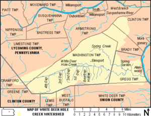
White Deer Hole Creek is a 20.5-mile (33.0 km) tributary of the West Branch Susquehanna River in Clinton, Lycoming and Union counties in the U.S. state of Pennsylvania. A part of the Chesapeake Bay drainage basin, the White Deer Hole Creek watershed drains parts of ten townships. The creek flows east in a valley of the Ridge-and-valley Appalachians, through sandstone, limestone, and shale from the Ordovician, Silurian, and Devonian periods.

The Union County Industrial Railroad is a short line railroad that operates on approximately 12 miles (20 km) of track in Union County in the U.S. State of Pennsylvania. It is part of the North Shore Railroad System.

The Great Island Path was a major Native American trail in the U.S. state of Pennsylvania that ran from the village of Shamokin along the right bank of the West Branch Susquehanna River north and then west to the Great Island.
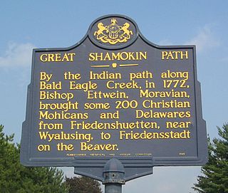
The Great Shamokin Path was a major Native American trail in the U.S. State of Pennsylvania that ran from the native village of Shamokin along the left bank of the West Branch Susquehanna River north and then west to the Great Island. There it left the river and continued further west to Chinklacamoose and finally Kittanning on the Allegheny River.

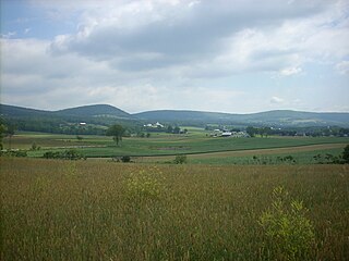
The West Branch Susquehanna Valley of central Pennsylvania, United States, in the Ridge-and-valley Appalachians, is the low-lying area draining into the West Branch Susquehanna River southeast of the Allegheny Front, northeast of the Bald Eagle Valley, southwest of the Wyoming Valley and north of the water gap formed between Shamokin Mountain and Montour Ridge.
The Sheshequin Path was a major Native American trail in the U.S. State of Pennsylvania that ran between two Native American villages: "French Margaret's Town" on the West Branch Susquehanna River and "Sheshequin" on the North Branch of the Susquehanna River. The path ran north and east along Lycoming Creek in Lycoming County and followed much of Towanda Creek in Bradford County. It was a shortcut between the two main branches of the Susquehanna River and was used by early settlers as well as Native Americans.

This article details a history of Lycoming County, Pennsylvania.

The Big Runaway was a mass evacuation in June and July 1778 of white settlers from the frontier regions of North Central Pennsylvania during the American Revolutionary War. It was precipitated by a series of raids against local settlements on the northern and western branches of the Susquehanna River by Loyalist troops and British-allied Indians, which prompted Patriot militia commanderes to order the evacuation. Most of the settlers relocated to Fort Augusta near modern-day Sunbury, Pennsylvania at the confluence of the northern and western branches of the Susquehanna River, while their abandoned houses and farms were all burnt as part of a scorched earth policy.

The Pine Creek Path was a major Native American trail in the U.S. State of Pennsylvania that ran north along Pine Creek from the West Branch Susquehanna River near Long Island to the headwaters of the Genesee River.

The Bald Eagle Creek Path was a major Native American trail in the U.S. State of Pennsylvania that ran from the Great Island on the West Branch Susquehanna River southwest to what is now the village of Frankstown on the Frankstown Branch Juniata River. The path ran from Clinton County southwest through Centre County and a small part of Blair County to its southern end in Blair County. It was part of a "Warriors Path", an important connector between paths leading to New York and the Six Nations of the Iroquois and the Ohio River country in the north and west, and paths leading to what are now Maryland, Virginia, and the Carolinas in the south.