Great Shamokin Path

Last updated

Great Shamokin Path Pennsylvania Historical Marker on Pennsylvania Route 150 west of Lock Haven Great Shamokin Path Historical Marker.JPG
Great Shamokin Path Pennsylvania Historical Marker on Pennsylvania Route 150 west of Lock Haven

The Great Shamokin Path (also known as the "Shamokin Path") was a major Native American trail in the U.S. State of Pennsylvania that ran from the native village of Shamokin (modern-day Sunbury) along the left bank of the West Branch Susquehanna River north and then west to the Great Island (near modern-day Lock Haven). There it left the river and continued further west to Chinklacamoose (what is now the borough of Clearfield) and finally Kittanning on the Allegheny River.

Contents

The Great Shamokin Path connected settlements along the Susquehanna River with those on the Allegheny River (and the Ohio River downstream of Kittanning). For several decades in the early 18th century, the villages of Shamokin and Kittanning were two of the most important Native American villages in Pennsylvania. The colonists recorded the path as used by Moravian Bishop Ettwein and his group of some 200 Lenape and Mohican Christians in 1772. They traveled west along the path from their village of Friedenshütten (Cabins of Peace) near modern Wyalusing on the North Branch of the Susquehanna to their new village of Friedensstadt (City of Peace) on the Beaver River in southwestern Pennsylvania.

Today a 4-mile (6.4 km) long rail trail in Armstrong County follows a short portion of the Great Shamokin Path, and the former course of the Rural Valley Railroad. [1]

Susquehanna to the Allegheny

In 1772, John Ettwein and his group of some 200 Christian Lenape and Mohican traveled west along The Great Shamokin Path from their village of Friedenshutten (Cabins of Peace) near modern Wyalusing on the North Branch Susquehanna River to their new village of Friedensstadt (City of Peace) on the Beaver River in southwestern Pennsylvania. Bishop John Ettwein.png
In 1772, John Ettwein and his group of some 200 Christian Lenape and Mohican traveled west along The Great Shamokin Path from their village of Friedenshütten (Cabins of Peace) near modern Wyalusing on the North Branch Susquehanna River to their new village of Friedensstadt (City of Peace) on the Beaver River in southwestern Pennsylvania.

The village of Shamokin was just south of the "forks of the Susquehanna", the confluence of the West Branch Susquehanna River with the Susquehanna River (also known as the North Branch). From there, the Great Shamokin Path headed north and forded the river (where current Northumberland developed), then went along the left (west) bank of the West Branch Susquehanna River to the Shawnee town of Chillisquaque on Chillisquaque Creek. The path continued north through what are now Milton and Watsontown, where the path forked into two branches, both leading to Canaserage on Muncy Creek (today Muncy).

At Canaserage the river and path turned west. At least two other paths led northeast: the Wyalusing Path (along Muncy Creek to Wyalusing); and the Towanda Path (to Towanda), both on the North Branch of the Susquehanna River.

The Great Shamokin Path led west to the village of Otstonwakin (now Montoursville) on Loyalsock Creek at the confluence with the West Branch of the Susquehanna, and upriver to French Margaret's Town (developed as western Williamsport) on Lycoming Creek. The Sheshequin Path led north along Lycoming Creek to Sheshequin (now Ulster) on the North Branch Susquhehanna River. Further west the path went through the village of Quenashawakee, forded Larrys Creek and Pine Creek and came to the Great Island (now just east of Lock Haven).

"The Big Spring" in Brady Township, Pennsylvania, was an important junction connecting the Great Shamokin Path and Goschgoschink Path. The Big Spring.jpg
"The Big Spring" in Brady Township, Pennsylvania, was an important junction connecting the Great Shamokin Path and Goschgoschink Path.

The Great Island was an important crossroads with paths leading in many directions. The Great Shamokin Path left the river here (which turns north) to continue west along Bald Eagle Creek, fording Beech Creek and following Marsh Creek and Little Marsh Creek to its end. Then it climbed the Allegheny Front to modern-day Snow Shoe and on to Moshannon, where there were two branches possible to Kylertown. The branches differed in their fords of Black Moshannon Creek and Moshannon Creek, both of which were difficult to cross. From Kylertown the path continued west, fording Clearfield Creek before reaching Chinklacamoose (now Clearfield).

At Chinklacamoose the Great Shamokin Path rejoined the West Branch Susquehanna River and followed it west seven miles (11 km) to Curwensville, Pennsylvania and Anderson Creek. Several crossings of the Susquehanna were needed to avoid thickets of mountain laurel bushes here. The path followed Anderson Creek Gorge a few miles, left it to go west to what is now Chestnut Grove, and then on to The Big Spring, near Luthersburg, Brady Township, Clearfield County, Pennsylvania.

Fort Augusta

Fort Augusta was a stronghold in Northumberland County, Pennsylvania, in the upper Susquehanna Valley from the time of the French and Indian War to the close of the American Revolution. The fort was erected by Col. William Clapham in 1756 at a site now within the limits of the city of Sunbury, in an area the Indians called "Shamokin." It was first constructed as part of the British defense against the raids of the French and Indians from the upper Allegheny region. Later, it served as a rebel American fortress during the American Revolution to aid in protecting settlers of the upper Susquehanna from Britain's Indian allies to the north. Named for Augusta of Saxe-Gotha, the mother of King George III, Fort Augusta was the largest of the Provincial forts. It was dismantled in 1794 after the United States gained independence.

During the French and Indian War in 1757–1758, several hundred French and Indian troops traveled the Great Shamokin Path in an effort to destroy Fort Augusta, the main stronghold of the English at the junction of the East and West branches of the Susquehanna River. This army was gathered from the French posts at Duquesne, Kittanning, Venango and Le Boeuf and assembled at the mouth of Anderson Creek. They constructed crude boats, rafts and bateau for passage down the Susquehanna River for the proposed attack. They dragged along with them two small brass cannon, but after reconnoitering, found the distance too great for the guns to shoot from the hill opposite the fort. The defense at Fort Augusta was strong enough to resist attack by storming or by siege, and the French attack was abandoned. A British defeat at Fort Augusta may have altered the history of the course of the French and Indian War. [3]

In the 21st century on the site of the old Fort, the Northumberland County Historical Society has its headquarters in the "Hunter House Museum." The museum contains historical and archaeological artifacts dealing with Fort Augusta and items of local history. It maintains a genealogical library of material on early families in Northumberland County and surrounding counties. The museum is located at 1150 North Front Street, Sunbury, Pennsylvania. Fort Augusta's underground powder magazine still exists.

Big Spring

Marker location U.S. 119, 4 miles NE of Punxsutawney, Jefferson County, PA Great Shamokin Path.jpg
Marker location U.S. 119, 4 miles NE of Punxsutawney, Jefferson County, PA

The Big Spring near Luthersburg, Brady Township, Clearfield County, Pennsylvania, was an important camp site and trail hub. Here, the Goschgoschink Path, later known as Mead's Path, turned northwest to the Venango Path, Lake Erie and Canada. The Great Shamokin Path continued through Troutville and followed tributaries of Mahoning Creek to Punxsutawney. From Punxsutawney, the trail followed Cowanshannock Creek to Smicksburg, Rural Valley, Kittanning and the Allegheny River. [4] During the War of 1812, Major William McCelland departed Fort Loudoun, near Chambersburg, Pennsylvania, on March 4, 1814 and marched a division of troops numbering 221 privates, three captains. five lieutenants and two ensigns along Anderson Creek to meet the Goschgoschink Path at the Big Spring. McClelland's division relieved American forces at Lake Erie and later fought well at the Battle of Chippewa and Battle of Lundy's Lane. [5] [6]

Amish country along the Great Shamokin Path

Amish buggy Lancaster County Amish 03.jpg
Amish buggy

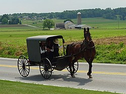
An Amish heritage corridor extends generally along the Great Shamokin Path through Clearfield, Jefferson, Indiana and Armstrong counties, beginning at Big Spring near Luthersburg, Clearfield County, and ending in Rural Valley in Armstrong County. The corridor winds through Amish settlements near the villages of Troutville in Clearfield County; Big Run, Cloe and Punxsutawney in Jefferson County; Smicksburg in Indiana County; and Rural Valley in Armstrong County. Amish buggies co-mingle with automobiles through the corridor. The Troutville Amish settlement in Brady Township, Clearfield County, is good-sized and has eight congregations. The settlement has farms, trades and small shops. Troutville was named for Jacob Trautwien who settled the area in 1832. [7] [8] [9]

The Smicksburg Amish settlement is centered on the borough of Smicksburg, Indiana County, about 10 miles southwest of Punxsutawney. The Smicksburg settlement is the third-largest Amish settlement in Pennsylvania, and the eleventh largest in the U.S. The Smicksburg settlement has 18 church districts and was founded in 1962. Amish here drive Midwestern-style black buggies. Smicksburg was founded in 1827 by the Reverend J. George Schmick, and most of the citizens are Amish. The population was 46 at the 2010 census, and is one of the smallest incorporated boroughs in Pennsylvania. The Smicksburg settlement has specialty shops with Amish wares of handcrafts, quilts, furniture, foods and eating establishments. [10] [11]

Rural Valley is a borough in Armstrong County, Pennsylvania, where the Cowanshannock Creek flows west leading to the Allegheny River. The population was 876 at the 2010 census. [12] The regional high school, West Shamokin High School, bears the name of the historic Great Shamokin Path.

Related Research Articles

<span class="mw-page-title-main">Armstrong County, Pennsylvania</span> County in Pennsylvania, United States

Armstrong County is a county in the Commonwealth of Pennsylvania. As of the 2020 census, the population was 65,558. The county seat is Kittanning. The county was organized on March 12, 1800, from parts of Allegheny, Westmoreland and Lycoming Counties. It was named in honor of John Armstrong, who represented Pennsylvania in the Continental Congress and served as a major general during the Revolutionary War.

<span class="mw-page-title-main">Jefferson County, Pennsylvania</span> County in Pennsylvania, United States

Jefferson County is a county in the Commonwealth of Pennsylvania. As of the 2020 census, the population was 44,492. Its county seat is Brookville. The county was established on March 26, 1804, from part of Lycoming County and later organized in 1830. It is named for President Thomas Jefferson. It is home to Punxsutawney Phil, the most famous groundhog that predicts when spring will come every February 2 on Groundhog Day. Jefferson County is in the sparsely populated Pennsylvania Wilds region.

<span class="mw-page-title-main">Brady Township, Clearfield County, Pennsylvania</span> Township in Pennsylvania, United States

Brady Township is a township in Clearfield County, Pennsylvania, United States. The population was 1,941 at the 2020 census.

<span class="mw-page-title-main">Smicksburg, Pennsylvania</span> Borough in Pennsylvania, United States

Smicksburg is a borough in Indiana County, Pennsylvania, United States. The population was 57 at the 2020 census, and it is one of the smallest incorporated boroughs in Pennsylvania. It was founded by the Reverend J. George Schmick.

<span class="mw-page-title-main">Kittanning Path</span>

The Kittanning Path was a major east-west Native American trail that crossed the Allegheny Mountains barrier ridge connecting the Susquehanna River valleys in the center of Pennsylvania to the highlands of the Appalachian Plateau and thence to the western lands beyond drained by the Ohio River. Kittanning Village was the first major Delaware (Lenape) Indian settlement along the descent from the Allegheny Plateau.

<span class="mw-page-title-main">West Branch Susquehanna River</span> River in Pennsylvania, United States

The West Branch Susquehanna River is one of the two principal branches, along with the North Branch, of the Susquehanna River in the Northeastern United States. The North Branch, which rises in upstate New York, is generally regarded as the extension of the main branch, with the shorter West Branch being its principal tributary.

<span class="mw-page-title-main">Wyalusing Path</span>

The Wyalusing Path or trail was a historical trace that ran from what is now Wyalusing to the Native American village of Canaserage in Pennsylvania in the United States. Wyalusing is on the east bank of the North Branch of the Susquehanna River in Bradford County and Muncy is on the east bank of the West Branch Susquehanna River in Lycoming County, so the path provided a short cut between the two main branches of the Susquehanna River. The alternative and much longer route was to follow the North Branch south from Wyalusing to the confluence with the West Branch at the Native village of Shamokin, then north up the West Branch to Muncy.

<span class="mw-page-title-main">Shamokin (village)</span> Historic Native American village in Pennsylvania

Shamokin was a multi-ethnic Native American trading village on the Susquehanna River, located partially within the limits of the modern cities of Sunbury and Shamokin Dam, Pennsylvania. It should not be confused with present-day Shamokin, Pennsylvania, located to the east. The village was the focus of missionary efforts, and then was the staging area for raids on English settlements in Pennsylvania during the French and Indian War. It was burned and abandoned by the Lenape in May, 1756. A few months later, Fort Augusta was constructed on the site of the village.

<span class="mw-page-title-main">Anderson Creek (Pennsylvania)</span> Stream in Pennsylvania, USA

Anderson Creek is a 23.6-mile-long (38.0 km) tributary of the West Branch Susquehanna River in Clearfield County, Pennsylvania, in the United States.

<span class="mw-page-title-main">Great Island Path</span>

The Great Island Path was a major Native American trail in the U.S. state of Pennsylvania that ran from the village of Shamokin along the right bank of the West Branch Susquehanna River north and then west to the Great Island.

Fort Augusta was a stronghold in Northumberland County, Pennsylvania, in the upper Susquehanna Valley from the time of the French and Indian War to the close of the American Revolution. At the time, it was the largest British fort in Pennsylvania, with earthen walls more than two hundred feet long topped by wooden fortifications. With a garrison of over 300 troops and walls specially constructed to resist artillery, it presented a formidable defense and was never attacked. It served as a refuge for local settlers during the French and Indian War and during the American Revolutionary War. It was abandoned in 1780 and dismantled in 1796.

<span class="mw-page-title-main">Great Indian Warpath</span> Trails in eastern North America used by Native Americans

The Great Indian Warpath (GIW)—also known as the Great Indian War and Trading Path, or the Seneca Trail—was that part of the network of trails in eastern North America developed and used by Native Americans which ran through the Great Appalachian Valley. The system of footpaths extended from what is now upper New York to deep within Alabama. Various Native peoples traded and made war along the trails, including the Catawba, numerous Algonquian tribes, the Cherokee, and the Iroquois Confederacy. The British traders' name for the route was derived from combining its name among the northeastern Algonquian tribes, Mishimayagat or "Great Trail", with that of the Shawnee and Delaware, Athawominee or "Path where they go armed".

<span class="mw-page-title-main">Sheshequin Path</span>

The Sheshequin Path was a major Native American trail in the U.S. State of Pennsylvania that ran between two Native American villages: "French Margaret's Town" on the West Branch Susquehanna River and "Sheshequin" on the North Branch of the Susquehanna River. The path ran north and east along Lycoming Creek in Lycoming County and followed much of Towanda Creek in Bradford County. It was a shortcut between the two main branches of the Susquehanna River and was used by early settlers as well as Native Americans.

<span class="mw-page-title-main">Pine Creek Path</span>

The Pine Creek Path was a major Native American trail in the U.S. State of Pennsylvania that ran north along Pine Creek from the West Branch Susquehanna River near Long Island to the headwaters of the Genesee River.

<span class="mw-page-title-main">Bald Eagle Creek Path</span>

The Bald Eagle Creek Path was a major Native American trail in the U.S. State of Pennsylvania that ran from the Great Island on the West Branch Susquehanna River southwest to what is now the village of Frankstown on the Frankstown Branch Juniata River. The path ran from Clinton County southwest through Centre County and a small part of Blair County to its southern end in Blair County. It was part of a "Warriors Path", an important connector between paths leading to New York and the Six Nations of the Iroquois and the Ohio River country in the north and west, and paths leading to what are now Maryland, Virginia, and the Carolinas in the south.

Bilger's Rocks is a park in Clearfield County, Pennsylvania, USA, near the town of Grampian in Bloom Township. The surrounding area is intricately laced with hills, mountains, and river valleys that generally follow the Appalachian mountain range in a northwest to southeast direction. The area of the park is located along the Allegheny section of the mountains, approximately 8 miles (13 km) southwest of the highest point on Interstate 80 east of the Mississippi River.

Lenape settlements are villages and other sites founded by Lenape people, a Native American tribe from the Northeastern Woodlands. Many of these sites are located in Ohio and Pennsylvania.

The Goschgoschink Path, later known as Mead's Path, begins at the junction of the Great Shamokin Path at The Big Spring near Luthersburg, Brady Township, Clearfield County, Pennsylvania. The path then proceeds to Thunderbird Spring, Sandy Valley Station, north of Reynoldsville, Jefferson County, thence through the Horme Settlement and slightly north of Emerickville to Brookville; north of Clarion, to West Hickory, Pennsylvania, in Forest County and the Allegheny River. From here, travelers could journey to Fort Le Boeuf and Lake Erie.

<span class="mw-page-title-main">Big Spring (Pennsylvania)</span>

The Big Spring near Luthersburg, Brady Township, Clearfield County, Pennsylvania, was an important camp site and trail hub for the Great Shamokin Path and the Goschgoschink Path.

Chinklacamoose, spelled many ways, was an old Native American village located at what is now Clearfield, Pennsylvania. The village existed from the early 1st century until around the mid to late 17th century. The village was about halfway along the Great Shamokin Path, which started at the old Indian village of Shamokin, along the West Branch of the Susquehanna River west to its ending point at the village of Kittanning.

References

  1. "The Great Shamokin Path". Armstrong County, Pennsylvania. Archived from the original on May 2, 2007. Retrieved August 2, 2008.
  2. "Appendix to the Report of the Gemeine in Bethlehem from the Month of January, 1802 containing the Lebenslauf of our late blessed beloved Brother Johannes Ettwein Bishop in the Church of the Brethren". Bethlehem Digital History Project. transcription & translation by Katherine E. Carté.{{cite web}}: CS1 maint: others (link)
  3. McCreight, M.I. (1939). "Memory Sketches of Du Bois, Pennsylvania: A History". Du Bois History. p. 69.
  4. Wallace, Paul A.W. (1998) [1987]. Indian Paths of Pennsylvania (fourth printing ed.). Harrisburg, Pennsylvania: Pennsylvania Historical and Museum Commission. pp. 66–72. ISBN   0-89271-090-X.
  5. McCreight, Major Israel (1939). Memory Sketches of Du Bois, Pennsylvania, 1874–1938: A History. DuBois, PA: Gray Printing. pp. 68–71. OCLC   28554939.
  6. Wallace, Paul A.W. (1965). Indian Paths of Pennsylvania. Harrisburg, PA: Pennsylvania Historical and Museum Commission. p. 61. OCLC   1078148 via The Noel Genealogical Site.
  7. Hershberger, Ben A.; Hershberger, Orpha. Troutville Directory: Migrations and History of Troutville, PA, 1971 to 2004 (third print ed.). Punxsutawney, PA.
  8. "Amish Trail". Amish America.
  9. "Amish Trail". Clearfield County PA — Backwoods, Backroads, Backwaters 2012.
  10. "(home)". Smickburg.
  11. "Groundhog Day Brain Dump: Punxsutawney Amish, "Grundsow Lodges", and the Miracle Heater in court?". Amish America. February 2, 2011.
  12. "Geographic Identifiers: 2010 Demographic Profile Data (G001): Rural Valley borough, Pennsylvania". U.S. Census Bureau, American Factfinder. Archived from the original on February 12, 2020. Retrieved July 31, 2013.