Weiser State Forest | |
Pennsylvania State Forest | |
Roaring Creek Trail in the Roaring Creek Tract | |
Country | United States |
---|---|
State | Pennsylvania |
Counties | Carbon, Columbia, Dauphin, Northumberland, Schuylkill |
Coordinates | 40°37′49″N76°11′35″W / 40.63028°N 76.19306°W Coordinates: 40°37′49″N76°11′35″W / 40.63028°N 76.19306°W |
Area | 17,961 acres (7,269 ha) |
Location of Weiser State Forest in Pennsylvania | |
Website: Weiser State Forest | |
Weiser State Forest is a Pennsylvania State Forest in Pennsylvania Bureau of Forestry District #18. The main offices are located in Cressona in Schuylkill County, Pennsylvania in the United States.
Cressona is a borough in Schuylkill County, Pennsylvania, United States. Formed in 1857 from part of North Manheim Township, it was founded by and named for John Chapman Cresson, a Philadelphia civil engineer and manager of the Schuylkill Navigation Company, President of the Mine Hill and Schuylkill Haven Railroad and chief engineer of Fairmount Park, Philadelphia.
Schuylkill County is a county in the Commonwealth of Pennsylvania. As of the 2010 census, the population was 148,289. The county seat is Pottsville. The county was created on March 1, 1811, from parts of Berks and Northampton counties and named for the Schuylkill River, which originates in the county. On March 3, 1818 additional territory in its northeast was added from Columbia and Luzerne Counties.
Pennsylvania, officially the Commonwealth of Pennsylvania, is a state located in the northeastern, Great Lakes and Mid-Atlantic regions of the United States. The Appalachian Mountains run through its middle. The Commonwealth is bordered by Delaware to the southeast, Maryland to the south, West Virginia to the southwest, Ohio to the west, Lake Erie and the Canadian province of Ontario to the northwest, New York to the north, and New Jersey to the east.
The forest is located on several small tracts in Carbon, Columbia, Dauphin, Northumberland, and Schuylkill counties. District #18 also includes Lebanon and Montour counties.
Carbon County is a county located in the U.S. state of Pennsylvania. As of the 2010 census, the population was 65,249. Its county seat is Jim Thorpe, founded in 1818 as Mauch Chunk, a company town of the Lehigh Coal & Navigation Company (LC&N) as it built a wagon road nine miles to their coal mine at today's Summit Hill, and constructed the Lehigh Canal navigations.
Columbia County is a county located in the U.S. state of Pennsylvania. As of the 2010 census, the population was 67,295. Its county seat is Bloomsburg. The county was created on March 22, 1813, from part of Northumberland County and named for Columbia, a poetic name for the United States that alludes to Christopher Columbus.
Dauphin County is a county in the U.S. state of Pennsylvania. As of the 2010 census, the population was 268,100. The county seat and the largest city is Harrisburg, Pennsylvania's state capital and tenth largest city. The county was created ("erected") on March 4, 1785, from part of Lancaster County and was named after Louis-Joseph, Dauphin of France, the first son of king Louis XVI.
Weiser State Forest was formed as a direct result of the depletion of the forests of Pennsylvania that took place during the mid-to-late 19th century. Conservationists like Dr. Joseph Rothrock became concerned that the forests would not regrow if they were not managed properly. Lumber and iron companies had harvested the old-growth forests for various reasons. They clear cut the forests and left behind nothing but dried tree tops and rotting stumps. The sparks of passing steam locomotives ignited wildfires that prevented the formation of second growth forests. The conservationists feared that the forest would never regrow if there was not a change in the philosophy of forest management. They called for the state to purchase land from the lumber and iron companies and the lumber and iron companies were more than willing to sell their land since that had depleted the natural resources of the forests. [1] The changes began to take place in 1895 when Dr. Rothrock was appointed the first commissioner of the Pennsylvania Department of Forests and Waters, the forerunner of today's Pennsylvania Department of Conservation and Natural Resources. The Pennsylvania General Assembly passed a piece of legislation in 1897 that authorized the purchase of "unseated lands for forest reservations." This was the beginning of the State Forest system. [1]
Joseph Trimble Rothrock was an American environmentalist, recognized as the "Father of Forestry" in Pennsylvania. In 1895, Rothrock was appointed the first forestry commissioner to lead the newly formed Division of Forestry in the Pennsylvania Department of Agriculture. Two of his major accomplishments as commissioner were his land acquisition program and the creation of a forest academy to train foresters for state service.
An old-growth forest — also termed primary forest or late seral forest — is a forest that has attained great age without significant disturbance and thereby exhibits unique ecological features and might be classified as a climax community. Old-growth features include diverse tree-related structures that provide diverse wildlife habitat that increases the biodiversity of the forested ecosystem. The concept of diverse tree structure includes multi-layered canopies and canopy gaps, greatly varying tree heights and diameters, and diverse tree species and classes and sizes of woody debris.
Clearcutting, clearfelling or clearcut logging is a forestry/logging practice in which most or all trees in an area are uniformly cut down. Along with shelterwood and seed tree harvests, it is used by foresters to create certain types of forest ecosystems and to promote select species that require an abundance of sunlight or grow in large, even-age stands. Logging companies and forest-worker unions in some countries support the practice for scientific, safety and economic reasons, while detractors consider it a form of deforestation that destroys natural habitats and contributes to climate change.
The forest is named for Conrad Weiser, an important Pennsylvanian in colonial days, especially known as an interpreter and emissary in councils between Native Americans and Pennsylvania.
Conrad Weiser, born Johann Conrad Weiser, Jr., was a Pennsylvania Dutch pioneer, interpreter and diplomat between the Pennsylvania Colony and Native Americans. He was a farmer, soldier, monk, tanner and judge. He contributed as an emissary in councils between Native Americans and the colonies, especially Pennsylvania, during the 18th century's tensions of the French and Indian War.
Native Americans, also known as American Indians, Indigenous Americans and other terms, are the indigenous peoples of the United States, except Hawaii. There are over 500 federally recognized tribes within the US, about half of which are associated with Indian reservations. The term "American Indian" excludes Native Hawaiians and some Alaska Natives, while Native Americans are American Indians, plus Alaska Natives of all ethnicities. Native Hawaiians are not counted as Native Americans by the US Census, instead being included in the Census grouping of "Native Hawaiian and other Pacific Islander".
Prior to the July 1, 2005 realignment of Pennsylvania State Forest Districts, Weiser State Forest encompassed 17,961 acres (7,269 ha) and District #18 included Carbon, Dauphin, Lebanon, Schuylkill, and the northern parts of Berks and Lehigh counties. After realignment, the state forest tracts in Columbia and Northumberland counties were added to Weiser State Forest, and Montour county became part of District #18 (they had previously been in Wyoming State Forest and District #20). Weiser State Forest and District #18 also lost territory as all of Berks and Lehigh counties became part of "Valley Forge State Forest" (renamed William Penn State Forest in August 2007) and District #17.
Wyoming State Forest was the name of the Pennsylvania State Forest in Pennsylvania Bureau of Forestry District #20. As of July 1, 2005, a reorganization of Pennsylvania State Forests in eastern Pennsylvania resulted in the elimination of the name "Wyoming State Forest". The District #20 main office was located in Bloomsburg in Columbia County, Pennsylvania in the United States.
William Penn State Forest is a Pennsylvania State Forest in Pennsylvania Bureau of Forestry District #17. The main offices are located in Elverson in Chester County, Pennsylvania in the United States.
Loyalsock State Forest is a Pennsylvania state forest in Pennsylvania Bureau of Forestry District #20. The forest spans across the northern tier's "Endless Mountains" and is a total of 114,552 acres (46,358 ha). The Loyalsock is a “working forest” and is managed for pure water, recreation, plant and animal habitats, sustainable timber, and natural gas.
Pinchot State Forest is a Pennsylvania State Forest in Pennsylvania Bureau of Forestry District #11. The main offices are located in Lackawanna State Park in North Abington Township in Lackawanna County, Pennsylvania, in the United States.
Delaware State Forest is a Pennsylvania state forest in Pennsylvania Bureau of Forestry District #19. The main offices are located in Swiftwater in Monroe County, Pennsylvania in the United States.
The Appalachian Trail runs through the state forest lands.
This is a list of properties and districts listed on the National Register of Historic Places in Pennsylvania. As of 2015, there are over 3,000 listed sites in Pennsylvania. Sixty-six of the 67 counties in Pennsylvania have listings on the National Register; Cameron County is the only county without any sites listed.
Rothrock State Forest is a Pennsylvania state forest in Pennsylvania Bureau of Forestry District #5. The main offices are located in Huntingdon in Huntingdon County, Pennsylvania in the United States.
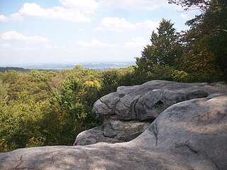
Bald Eagle State Forest is a Pennsylvania state forest in Pennsylvania Bureau of Forestry District #7. The main office is located in Laurelton in Union County, Pennsylvania, in the United States. The forest is found in Centre, Clinton, Mifflin, Snyder, and Union Counties. Bald Eagle shares a common border on its western extent with Rothrock State Forest and on its northern extent with Tiadaghton State Forest.
Tuscarora State Forest is a Pennsylvania state forest in Pennsylvania Bureau of Forestry District #3. The main office is located in Blain in Perry County, Pennsylvania in the United States.
Moshannon State Forest is a Pennsylvania State Forest in Pennsylvania Bureau of Forestry District #9. The main offices are located in the unincorporated village of Penfield in Huston Township, Clearfield County, Pennsylvania in the United States.
Susquehannock State Forest is a Pennsylvania state forest in Pennsylvania Bureau of Forestry District #15. The main office is located in Coudersport in Potter County, Pennsylvania in the United States.
Cornplanter State Forest is a Pennsylvania State Forest in Pennsylvania Bureau of Forestry District #14. The main office is located in North Warren in Warren County, Pennsylvania, in the United States. It is named for Chief Cornplanter of the Seneca Nation, one of the tribes of the Iroquois Confederacy.
Forbes State Forest is a Pennsylvania state forest in Pennsylvania Bureau of Forestry District #4. The main offices are located in Laughlintown in Westmoreland County, Pennsylvania in the United States. Mount Davis, the highest peak in Pennsylvania, is located in the forest.
Gallitzin State Forest is a Pennsylvania State Forest in Pennsylvania Bureau of Forestry District #6. The main offices are located in Ebensburg in Cambria County, Pennsylvania in the United States.
Clear Creek State Forest is a Pennsylvania State Forest in Pennsylvania Bureau of Forestry District #8. The main offices are located in Clarion in Clarion County, Pennsylvania in the United States. Until August 2007, it was named Kittanning State Forest.
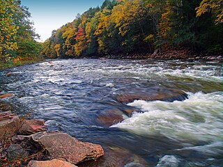
Tiadaghton State Forest is a Pennsylvania State Forest in the Pennsylvania Bureau of Forestry District #12. The forest is chiefly in western and southern Lycoming County, with small portions in Clinton, Potter, Tioga, and Union Counties.
Sproul State Forest is a Pennsylvania state forest in Pennsylvania Bureau of Forestry District #10. The main offices are located in Renovo, Pennsylvania in Clinton County in the United States.
Tioga State Forest is a Pennsylvania State Forest in District #16, in the Allegheny Plateau region within Tioga County, Pennsylvania.
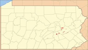
Michaux State Forest is a Pennsylvania State Forest in Pennsylvania Bureau of Forestry District #1. The main offices are located in Fayetteville in Franklin County, Pennsylvania, USA.
Buchanan State Forest is a Pennsylvania State Forest in Pennsylvania Bureau of Forestry District #2. The main office is located in McConnellsburg in Fulton County, Pennsylvania, in the United States. It is named for James Buchanan of Pennsylvania, the fifteenth President of the United States.