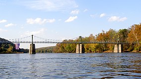
The Delaware River is a major river in the Mid-Atlantic region of the United States. From the meeting of its branches in Hancock, New York, the river flows for 282 miles (454 km) along the borders of New York, Pennsylvania, New Jersey, and Delaware, before emptying into Delaware Bay. It is the longest free-flowing river in the Eastern United States.
Tinicum Township is a township in Bucks County, Pennsylvania, United States. The population was 3,995 at the 2010 census.

The National Wild and Scenic Rivers System was created by the Wild and Scenic Rivers Actof 1968, enacted by the U.S. Congress to preserve certain rivers with outstanding natural, cultural, and recreational values in a free-flowing condition for the enjoyment of present and future generations.

The Lehigh River is a 109-mile-long (175 km) tributary of the Delaware River in eastern Pennsylvania. The river flows in a generally southward pattern from The Poconos in Northeastern Pennsylvania through Allentown and much of the Lehigh Valley before enjoining the Delaware River in Easton.

The protected areas of the United States are managed by an array of different federal, state, tribal and local level authorities and receive widely varying levels of protection. Some areas are managed as wilderness, while others are operated with acceptable commercial exploitation. As of 2022, the 42,826 protected areas covered 1,235,486 km2 (477,024 sq mi), or 13 percent of the land area of the United States. This is also one-tenth of the protected land area of the world. The U.S. also had a total of 871 National Marine Protected Areas, covering an additional 1,636,523 km2 (631,865 sq mi), or 19 percent of the total marine area of the United States.

The Maurice River ) is a tributary of Delaware Bay in Salem County and Cumberland County, New Jersey in the United States. The river was named for Maurice, Prince of Orange.

White Clay Creek is an 18.5-mile-long (29.8 km) tributary of the Christina River in southern Pennsylvania and northern Delaware in the United States. It is renowned for its scenic character and is largely federally protected.

Darby Creek is a tributary of the Delaware River in Chester, Delaware and Philadelphia counties, in the U.S. Commonwealth of Pennsylvania. It is approximately 26 miles (42 km) long. The watershed of the creek has an area of 77.2 square miles (200 km2). It has twelve named direct tributaries, including Cobbs Creek, Little Darby Creek, Ithan Creek, and Muckinipattis Creek. The creek has a low level of water quality for most of its length. The lower Darby Creek area was deemed a Superfund site by the U.S. Environmental Protection Agency (EPA) due to contamination with dangerous chemicals from two landfills.

Tohickon Creek is a 29.5-mile-long (47.5 km) tributary of the Delaware River. Located entirely in Bucks County, in southeastern Pennsylvania, it rises in Springfield Township and has its confluence with the Delaware at Point Pleasant. It is dammed to form Lake Nockamixon.

Little Beaver Creek is a wild and scenic area in Ohio. The Little Beaver Creek watershed is located primarily in Columbiana County in eastern Ohio, and in portions of Carroll County, Mahoning County, and western Pennsylvania, draining approximately 605 mi² (1,567 km²), of which 503 mi² (1,303 km²) are in Ohio. The watershed in total size covers an area of approximately 510 square miles, with about 80% of this being situated in Ohio. The great majority of land within the watershed is privately owned. Within the watershed are roughly 808 miles of linear streams.

Pennsylvania Route 32 is a scenic two-lane highway that runs along the west side of the Delaware River in Bucks County, Pennsylvania. It runs from U.S. Route 1 in Falls Township outside of Morrisville northwest to PA 611 in the village of Kintnersville in Nockamixon Township. PA 32 passes through Washington Crossing Historic Park, a Revolutionary War-themed historical park on the site of George Washington's crossing on the night of December 25–26, 1776. It also passes through the boroughs of Morrisville, Yardley, and New Hope.
The Upper Delaware Scenic and Recreational River is a unit of the National Park Service designated under the National Wild and Scenic Rivers System. It stretches along 73.4 miles (118.1 km) of the Delaware River between Hancock, New York, and Sparrowbush, New York. It includes parts of Delaware County, Orange County, and Sullivan County in New York, as well as Pike County and Wayne County in Pennsylvania. Most of the land in this unit is privately owned; the federal government only owns about 30 acres (12 ha).
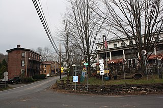
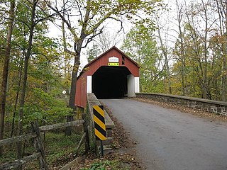
Point Pleasant is an unincorporated community in Tinicum and Plumstead Townships of Bucks County, Pennsylvania, United States. It lies on both sides of Tohickon Creek by the creek's confluence with the Delaware River; the creek is the dividing line between the townships. The ZIP code for the post office in Point Pleasant is 18950.

White Clay Creek State Park is a Delaware state park along White Clay Creek on 3,647 acres (1,476 ha) in New Castle County, near Newark, Delaware in the United States. North of the park is Pennsylvania's White Clay Creek Preserve, and the two were originally operated as bi-state parks to jointly protect the creek, but now they operate separately. The White Clay Creek is federally protected as part of the National Park Service's National Wild and Scenic Rivers System. White Clay Creek State Park offers 37 miles (60 km) of nature and fitness trails which are open to hiking and mountain biking 365 days a year with access at a number of seasonal day-use fee parking lots. Fee season is in effect March 1 - November 30. Fees are $4 for in-state vehicle or $8 for out of state vehicles. Annual passes can be purchased at any DE State Park Office or online. The park also preserves a number of historic structures and operates a nature center. It is part of the Northeastern coastal forests ecoregion.
Ralph Stover State Park is a Pennsylvania state park on 45 acres (18 ha) in Plumstead and Tinicum Townships, Bucks County, Pennsylvania in the United States. It is a very popular destination for whitewater kayaking on Tohickon Creek and rock climbing on High Rocks. Ralph Stover State Park is two miles (3.2 km) north of Point Pleasant near Pennsylvania Route 32.
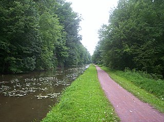
Delaware Canal State Park is a 830-acre (336 ha) Pennsylvania state park in Bucks and Northampton Counties in Pennsylvania. The main attraction of the park is the Delaware Canal which runs parallel to the Delaware River between Easton and Bristol.
The Delaware River Greenway Partnership (DRGP) is a non-profit organization, created in 1989 and located in Stockton, New Jersey, in the historic Prallsville Mills complex. DRGP's mission is to promote cross-river connections and communication, and to preserve and enhance the natural and historic resources of the lower Delaware River in both New Jersey and Pennsylvania.
Paunnacussing Creek is a tributary of the Delaware River contained wholly within Bucks County, Pennsylvania in the United States. It rises from a pond north of Mechanicsville, in Buckingham Township and drains into the Delaware at Bull Island just upstream of Lumberville in Solebury Township.
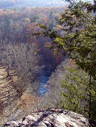
Tinicum Creek is a tributary of the Delaware River in Tinicum Township, Bucks County, Pennsylvania. It flows for 6.40 miles (10.30 km) from the confluence of its branches, Beaver Creek and Rapp Creek, before entering the river across from Marshall Island. Tinicum Creek and its two branches are part of the federally-designated Lower Delaware National Wild and Scenic River.