Route 29 is a state highway in the U.S. state of New Jersey. Signed north-south, it runs 34.76 mi (55.94 km) from an interchange with Interstate 295 (I-295) in Hamilton Township in Mercer County, where the road continues east as I-195, northwest to Route 12 in Frenchtown, Hunterdon County. Between the southern terminus and I-295 in Ewing Township, the route is a mix of expressway and boulevard that runs along the Delaware River through Trenton. This section includes a truck-restricted tunnel that was built along the river near historic houses and Riverview Cemetery. North of I-295, Route 29 turns into a scenic and mostly two-lane highway. North of the South Trenton Tunnel, it is designated the Delaware River Scenic Byway, a New Jersey Scenic Byway and National Scenic Byway, that follows the Delaware River in mostly rural sections of Mercer County and Hunterdon County. The obsolete Delaware & Raritan Canal usually stands between the river and the highway. Most sections of this portion of Route 29 are completely shaded due to the tree canopy. Route 29 also has a spur, Route 129, which connects Route 29 to U.S. Route 1 (US 1) in Trenton.

The Delaware Valley, sometimes referred to as Greater Philadelphia or the Philadelphia metropolitan area, is a major metropolitan region in the Northeast United States that centers around Philadelphia, the nation's sixth-most populous city, and spans parts of four U.S. states: southeastern Pennsylvania, southern New Jersey, northern Delaware, and the northern Eastern Shore of Maryland. With a core metropolitan statistical area population of 6.288 million residents and a combined statistical area population of 7.366 million as of the 2020 census, the Delaware Valley is the eighth-largest metropolitan region in the United States and the 68th-largest metropolitan region in the world.

Interstate 676 (I-676) is an Interstate Highway that serves as a major thoroughfare through Center City Philadelphia, where it is known as the Vine Street Expressway, and Camden, New Jersey, where it is known as the northern segment of the North–South Freeway, as well as the Martin Luther King Jr. Memorial Highway in honor of civil rights leader Martin Luther King Jr. Its western terminus is at I-76 in Philadelphia near the Philadelphia Museum of Art and Fairmount Park. From there, it heads east and is then routed on surface streets near Franklin Square and Independence National Historical Park, home of the Liberty Bell, before crossing the Delaware River on the Benjamin Franklin Bridge. On the New Jersey side of the bridge, the highway heads south to its southern terminus at I-76 in Gloucester City near the Walt Whitman Bridge. Between the western terminus and downtown Camden, I-676 is concurrent with U.S. Route 30 (US 30).

Transportation in Philadelphia involves the various modes of transport within the city and its required infrastructure. In addition to facilitating intracity travel, Philadelphia's transportation system connects Philadelphia to towns of its metropolitan area and surrounding areas within the Northeast megalopolis.

The Schuylkill Expressway, locally known as "the Schuylkill", is a freeway through southern Montgomery County and Philadelphia. It is the easternmost segment of Interstate 76 (I-76) in the U.S. state of Pennsylvania. It extends from the Valley Forge interchange of the Pennsylvania Turnpike in King of Prussia, paralleling its namesake Schuylkill River for most of the route, southeast to the Walt Whitman Bridge over the Delaware River in South Philadelphia. It serves as the primary corridor into Philadelphia from points west. Maintenance and planning for most of the highway are administered through Pennsylvania Department of Transportation (PennDOT) District 6, with the Delaware River Port Authority (DRPA) maintaining the approach to the Walt Whitman Bridge.

Penn's Landing is a waterfront area of Center City Philadelphia, Pennsylvania, situated along the Delaware River. Its name commemorates the landing of William Penn, the founder of Pennsylvania, in 1682. The actual landing site is farther south, in Chester. The city of Philadelphia purchased the right to use the name. Penn's Landing is bounded by Front Street to the west, the Delaware River to the east, Spring Garden Street to the north, and Washington Avenue to the south, and is primarily focused on the Christopher Columbus Boulevard corridor.

Pennsylvania Route 611 is a state highway in eastern Pennsylvania running 109.7 mi (176.5 km) from Interstate 95 (I-95) in the southern part of Philadelphia north to I-380 in Coolbaugh Township in the Pocono Mountains.

Broad Street is a major arterial street in Philadelphia, Pennsylvania. The street runs for approximately 13 miles (21 km), beginning at the intersection of Cheltenham Avenue on the border of Cheltenham Township and the West/East Oak Lane neighborhoods of North Philadelphia to the Philadelphia Navy Yard in South Philadelphia. It is Pennsylvania Route 611 along its entire length with the exception of its northernmost part between Old York Road and Pennsylvania Route 309 and the southernmost part south of Interstate 95.

Tacony is a historic neighborhood in Northeast Philadelphia, United States, approximately 8 miles (13 km) from downtown Philadelphia. It is bounded by the east side of Frankford Avenue on the northwest, the south side of Cottman Avenue on the northeast, the north side of Robbins Street on the southwest, and the Delaware River and Interstate 95 on the southeast.

Market Street, originally known as High Street, is a major east–west highway and street in Philadelphia, Pennsylvania, United States. The street is signed as Pennsylvania Route 3 between 38th Street and 15th Street. A short portion of the road continues west from Cobbs Creek Parkway to Delaware County, adjacent to Philadelphia. The street also serves as the dividing line for the "north" and "south" sides of the city. All north-south addresses in the city start at zero at Market Street.

Interstate 95 (I-95) is a major north–south Interstate Highway that runs along the East Coast of the United States from Miami, Florida, north to the Canada–United States border at Houlton, Maine. In the state of Pennsylvania, it runs 51.00 miles (82.08 km) from the Delaware state line near Marcus Hook in Delaware County in the southeastern part of the state northeast to the Delaware River–Turnpike Toll Bridge at the New Jersey state line near Bristol in Bucks County, closely paralleling the New Jersey state line for its entire length through Pennsylvania.

Pennsylvania Route 291 is an east–west state route in Pennsylvania that runs from U.S. Route 13 and US 13 Business in Trainer, Delaware County, east to Interstate 76 (I-76) in South Philadelphia near the Walt Whitman Bridge and the South Philadelphia Sports Complex. Except for a short 1-mile (1.6 km) section between the western terminus and the Chester/Trainer line, PA 291 is mostly a four-lane highway. From the western terminus to the eastern part of Chester, the route has a concurrency with US 13. It runs parallel to the Delaware River for much of the route. The route passes through industrial areas near the river in Delaware County, serving Chester, Eddystone, Essington, and Lester. PA 291 enters Philadelphia near the Philadelphia International Airport, at which point it has an interchange with I-95. The route crosses the Schuylkill River on the George C. Platt Memorial Bridge and continues along Penrose Avenue to I-76. It has been designated the Industrial Heritage Highway.

U.S. Route 1 (US 1) is a major north–south U.S. Route, extending from Key West, Florida, in the south to Fort Kent, Maine, at the Canada–United States border in the north. In the U.S. state of Pennsylvania, US 1 runs for 81 miles (130 km) from the Maryland state line near Nottingham northeast to the New Jersey state line at the Delaware River in Morrisville, through the southeastern portion of the state. The route runs southwest to northeast and serves as a major arterial road through the city of Philadelphia and for many of the suburbs in the Delaware Valley metropolitan area. South of Philadelphia, the road mostly follows the alignment of the Baltimore Pike. Within Philadelphia, it mostly follows Roosevelt Boulevard. North of Philadelphia, US 1 parallels the route of the Lincoln Highway. Several portions of US 1 in Pennsylvania are freeways, including from near the Maryland state line to Kennett Square, the bypass of Media, the concurrency with Interstate 76 and the Roosevelt Expressway in Philadelphia, and between Bensalem Township and the New Jersey state line.
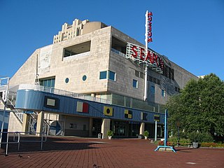
The Independence Seaport Museum was founded in 1961 and is located in the Penn's Landing complex along the Delaware River in Philadelphia, Pennsylvania. The collections at the Independence Seaport Museum document maritime history and culture along the Delaware River. At the museum are two National Historic Landmark ships and the J. Welles Henderson Archives and Library.

Spring Garden is a neighborhood in central Philadelphia, Pennsylvania, bordering Center City on the north. Spring Garden is a neighborhood that combines diverse residential neighborhoods and significant cultural attractions.

U.S. Route 13 (US 13) is a United States Numbered Highway running from Fayetteville, North Carolina, north to Morrisville, Pennsylvania. The route runs for 49.359 miles (79.436 km) through the Delaware Valley in the U.S. state of Pennsylvania. The route enters the state from Delaware in Marcus Hook, Delaware County. It continues northeast through Delaware County, passing through the city of Chester before heading through suburban areas along Chester Pike to Darby. US 13 enters the city of Philadelphia on Baltimore Avenue and runs through West Philadelphia to University City, where it turns north along several city streets before heading east across the Schuylkill River along Girard Avenue. The route turns north and heads to North Philadelphia, where it runs northeast along Hunting Park Avenue. US 13 becomes concurrent with US 1 on Roosevelt Boulevard, continuing into Northeast Philadelphia. US 13 splits southeast on a one-way pair of streets before heading northeast out of the city on Frankford Avenue. The route continues into Bucks County as Bristol Pike, heading northeast to Bristol, where it becomes a divided highway. US 13 becomes a freeway in Tullytown and continues north to its terminus at US 1 in Falls Township, near Morrisville. US 13 roughly parallels Interstate 95 (I-95) through its course in Pennsylvania.
U.S. Route 13 (US 13) runs along the Atlantic coastline for over 500 miles (800 km), passing through five states. Along its route, it possessed numerous special routes, which are all loops off the mainline US 13. At present, there are at least 15 special routes in existence: two in North Carolina, five in Virginia, two in Maryland, four in Delaware, and two in Pennsylvania. 13 others have existed in the past but have been deleted.

State Route 2005 is a major 9.3 mile (15 km) long road, running in a southeast–northwest direction in Delaware County, Pennsylvania. The western terminus is at Pennsylvania Route 320 in Haverford Township, Pennsylvania. Its eastern terminus is at a Cobbs Creek bridge in Darby, Pennsylvania. Past this bridge is State Route 3023, which continues into Philadelphia. SR 2005 is known as Darby Road in Haverford Township, Lansdowne Avenue from U.S. Route 1 to Darby, and Main Street in Darby.
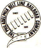
The Philadelphia Belt Line Railroad owns a 2.66-mile (4.28 km) long railroad line running along the Delaware River waterfront in Philadelphia, Pennsylvania. It was created in 1889 to allow any Philadelphia railroad to access the waterfront. The railroad, which does not operate any trains itself, is currently maintained by Conrail Shared Assets Operations and used by CSX Transportation and Norfolk Southern Railway.

The Philadelphia Korean War Memorial at Penn's Landing in Philadelphia was initially dedicated on June 22, 2002 and was formally rededicated on Memorial Day, May 28, 2007 after additional work was completed. Each name of the more than 600 servicemen who were killed in action or listed as missing in action during the Korean War from Bucks, Chester, Delaware, Montgomery, and Philadelphia counties are etched in the memorial. Veterans Day and Memorial Day services are held onsite annually.