
The Crow Wing River is a 113-mile-long (182 km) tributary of the Mississippi River in Minnesota, United States. The river rises at an elevation of about 1391 feet in a chain of 11 lakes in southern Hubbard County, Minnesota, and flows generally south, then east, entering the Mississippi at Crow Wing State Park northwest of Little Falls, Minnesota. Its name is a loose translation from the Ojibwe language Gaagaagiwigwani-ziibi. A wing-shaped island at its mouth accounts for the river's name. Because of its many campsites and its undeveloped shores, the Crow Wing River is considered one of the state's best "wilderness" routes for canoeists; although it is shallow, it is nearly always deep enough for canoeing.

Tuscarora State Park is a Pennsylvania state park on 1,618 acres (655 ha) in Rush, Ryan, Schuylkill Townships, Schuylkill County, Pennsylvania in the United States. The most prominent features of the park are Locust Mountain and Tuscarora Lake. The park is named for the Tuscarora Indians, who lived in the area, following the Tuscarora War in North Carolina, until they were forced out by the colonial settlers of Pennsylvania. Tuscarora State Park is 2 miles (3.2 km) west of Tamaqua just off of Pennsylvania Route 54.

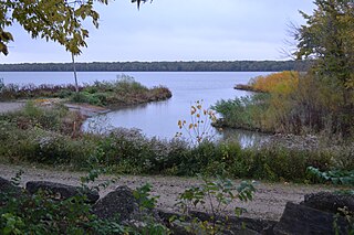
Maurice K. Goddard State Park is a 2,856-acre (1,156 ha) Pennsylvania state park in Deer Creek, Mill Creek, New Vernon and Sandy Lake Townships, Mercer County, Pennsylvania in the United States. It features wildlife, waterways and public recreational facilities. Lake Wilhelm shares its shorelines with Maurice K. Goddard State Park and State Game Land No. 270. The dam, constructed in 1971, creates a 1,860-acre (750 ha) lake providing a resource for people and wildlife. Many species of fish and amphibians make Lake Wilhelm their home. A variety of outdoor activities are available in and around the park vicinity. Special events and programs are held throughout the summer months. Maurice K. Goddard State Park is just off exit 130 of Interstate 79 on Pennsylvania Route 358.

Pymatuning State Park is a Pennsylvania state park covering 21,122 acres (8,548 ha) in Conneaut, North Shenango, Pine, Sadsbury, South Shenango, West Fallowfield and West Shenango Townships, Crawford County, Pennsylvania, in the United States. Pymatuning State Park is the largest state park in Pennsylvania and contains the 17,088 acres (69.15 km2) of Pymatuning Lake, three-quarters of which is in Pennsylvania and one-quarter of which is in Ohio. A 1.7-mile (2.7 km) causeway extends between Pennsylvania and Ohio near the center of the lake. The lake provides fishing and boating year round. There are two natural areas, Clark Island and Blackjack in the park. The park is also home to the University of Pittsburgh's Pymatuning Laboratory of Ecology. Like all Pennsylvania state parks, admission to the Pymatuning State Park is free. The northern access for Pymatuning State Park can be reached from U.S. Route 6 and the southern access is reached from U.S. Route 322.

Shawnee State Park is a 3,983-acre (1,612 ha) Pennsylvania state park in Juniata and Napier Townships, Bedford County, Pennsylvania in the United States. Shawnee Lake, a 451-acre (183 ha) warm water reservoir, is at the center of the park as its main attraction. The park's main entrance is just east of Schellsburg, along U.S. Route 30 and about 10 miles (16 km) west of the county seat of Bedford. The park is also easily accessed via State Route 31 and by State Route 96.

The Western Pennsylvania Conservancy (WPC) is a private nonprofit conservation organization founded in 1932 and headquartered in Pittsburgh, Pennsylvania. WPC has contributed land to 12 state parks and conserved more than a quarter million acres of natural lands. The Conservancy plants and maintains more than 132 gardens in 20 Western Pennsylvania counties, as well as planting thousands of trees through its community forestry program. WPC has protected or restored more than 3,000 miles (4,800 km) of rivers and streams. In 1963, Edgar Kaufmann Jr. entrusted Frank Lloyd Wright's masterwork Fallingwater to the Conservancy. The house was called the most important building of the 20th century by the American Institute of Architects.
The Pennsylvania State Game Lands (SGL) are lands managed by the Pennsylvania Game Commission (PGC) for hunting, trapping, and fishing. These lands, often not usable for farming or development, are donated to the PGC or purchased by the PGC with hunting license money.

Sam D. Hamilton Noxubee National Wildlife Refuge is a 48,000 acres (190 km2) National Wildlife Refuge located in the U.S. state of Mississippi, in Noxubee, Oktibbeha, and Winston Counties. The refuge serves as a resting and feeding area for migratory birds and as example of proper land stewardship. Also, the refuge extensively manages land for the endangered red-cockaded woodpecker.

Erie Bluffs State Park is a 587-acre (238 ha) Pennsylvania state park in Girard and Springfield Townships, Erie County, Pennsylvania in the United States. The park is the largest undeveloped stretch of land overlooking Lake Erie in Pennsylvania. Erie Bluffs State Park is just north of Pennsylvania Route 5 near Lake City and 12 miles (19 km) west of Erie. It is one of Pennsylvania's newest state parks.

Boyd Big Tree Preserve Conservation Area is a 949.49-acre (384.24 ha) Pennsylvania state park in Lower Paxton and Middle Paxton Townships in Dauphin County, Pennsylvania. The land for the conservation area was donated to the state by real estate developer Alex Boyd in 1999. Boyd Big Tree Preserve Conservation Area is a sanctuary for mature trees and an environment education study area. The park is on Blue Mountain just off Pennsylvania Route 443.

Nescopeck State Park is a Pennsylvania state park on 3,550 acres (1,437 ha) in Butler and Dennison Townships, Luzerne County, Pennsylvania. The park is one of the newest state parks in Pennsylvania. In the early 1970s, the state acquired 164 properties which made up the park. The park's Environmental Education Center is one of its newest additions; it opened in April 2005. Nescopeck Creek runs through the valley between Mount Yeager and Nescopeck Mountain. The park is near Interstate 80 just off Pennsylvania Route 309.
Marshall State Fish and Wildlife Area is an Illinois state park on 6,000 acres (2,400 ha) in Marshall County, Illinois, United States.

The Boggs Lake Ecological Reserve is a nature reserve in Lake County, California. The land area is about one quarter of a square mile and contains a large vernal pool as well as endangered plants such as the Boggs Lake hedge-hyssop.

Pennsylvania State Game Lands Number 226 are Pennsylvania State Game Lands in Columbia County, Pennsylvania. They have an area of 4,335 acres (1,754 ha). The terrain of the game lands mainly consists of woodlots and food plots. Streams such as Spruce Run and East Branch Chillisquaque Creek are within their boundaries. The main game animals in these game lands include deer, grouse, squirrel, and turkey.
Pennsylvania State Game Lands Number 12 are Pennsylvania State Game Lands in Bradford County and Sullivan County, in Pennsylvania, in the United States. The game lands have an area of nearly 24,480 acres (9,910 ha) in Bradford County. The area is mainly mountainous and wooded and major streams in the area include Schrader Creek, Sugar Run, and Little Schrader Creek. Game animals within the game lands include black bear, gray squirrel, whitetail deer, and wild turkey. The main hardwood tree species include American basswood, American beech, black cherry, black birch, red maple, sugar maple, white ash, and aspen. The main conifer species include eastern hemlock, eastern larch, plantation Norway spruce, plantation red pine, and white pine.

The South Dakota Department of Game, Fish, and Parks (GFP) is the U.S. State of South Dakota's state agency charged with the management of the state's public recreational and outdoor resources. The GFP manages the 13 state parks and 43 state recreation areas within the state parks system, totaling over 96,000 acres of public lands. The agency manages the hunting of game and the state's fisheries, manages several wildlife management areas and game production areas to restore or establish habitat for a variety of species. The agency conducts public outdoor education programs, typically focusing on hunting and boating safety. The department issues hunting and fishing licenses along with issuance of boat registrations. The agency is also charged with enforcement of fish and game laws, including invasive species regulations. The agency is headquartered in Pierre, South Dakota.
The Pennsylvania State Game Lands Number 203 are Pennsylvania State Game Lands located in Allegheny County, Pennsylvania in the United States.
The Pennsylvania State Game Lands Number 189 are Pennsylvania State Game Lands in Beaver County in Pennsylvania in the United States providing hunting, bird watching, cross-country skiing, and other activities.
The Pennsylvania State Game Lands Number 41 are Pennsylvania State Game Lands in Bedford and Blair Counties in Pennsylvania in the United States providing hunting, bird watching, and other activities.
The Pennsylvania State Game Lands Number 118 are Pennsylvania State Game Lands in Blair and Huntingdon counties in Pennsylvania in the United States, providing hunting, bird watching, and other activities.
