Tuscarora State Park is a Pennsylvania state park on 1,618 acres (655 ha) in Rush, Ryan, Schuylkill Townships, Schuylkill County, Pennsylvania in the United States. The most prominent features of the park are Locust Mountain and Tuscarora Lake. The park is named for the Tuscarora Indians, who lived in the area, following the Tuscarora War in North Carolina, until they were forced out by the colonial settlers of Pennsylvania. Tuscarora State Park is 2 miles (3.2 km) west of Tamaqua just off of Pennsylvania Route 54.

Rothrock State Forest is a Pennsylvania state forest in Pennsylvania Bureau of Forestry District #5. The main offices are located in Huntingdon in Huntingdon County, Pennsylvania in the United States.

Bald Eagle State Forest is a Pennsylvania state forest in Pennsylvania Bureau of Forestry District #7. The main office is located in Laurelton in Union County, Pennsylvania. The forest is found in Centre, Clinton, Mifflin, Snyder, and Union Counties. Bald Eagle shares a common border on its western extent with Rothrock State Forest and on its northern extent with Tiadaghton State Forest.

Susquehannock State Forest is a Pennsylvania state forest in Pennsylvania Bureau of Forestry District #15. The main office is located in Coudersport in Potter County, Pennsylvania in the United States.
Cornplanter State Forest is a Pennsylvania State Forest in Pennsylvania Bureau of Forestry District #14. The main office is located in North Warren in Warren County, Pennsylvania, in the United States. It is named for Chief Cornplanter of the Seneca Nation, one of the tribes of the Iroquois Confederacy.
Elk State Forest is a Pennsylvania State Forest in Pennsylvania Bureau of Forestry District #13. The main offices are located in Emporium in Cameron County, Pennsylvania.

William Penn State Forest is a Pennsylvania State Forest in Pennsylvania Bureau of Forestry District #17. The main offices are located in Elverson in Chester County, Pennsylvania in the United States.

Tiadaghton State Forest is a Pennsylvania State Forest in the Pennsylvania Department of Conservation and Natural Resources, Bureau of Forestry. The forest is primarily in western and southern Lycoming County, with small portions in Clinton, Potter, Tioga, and Union Counties. The district's topography consists of narrow, flat to sloping plateaus cut by deep, steep-sloped valleys carved by fast moving mountain streams, including Pine Creek, Slate Run, and their tributaries. The Tiadaghton district extends south across the lowland along the west branch of the Susquehanna River to the narrow crests of Bald Eagle Mountain and North and South White Deer Ridge. The majority of forest cover is dominated by mixed oak forests, with some areas of northern hardwoods. The Tiadaghton State Forest is one of eight forest districts in the Pennsylvania Wilds region.

Sproul State Forest is a Pennsylvania state forest in Pennsylvania Bureau of Forestry District #10. The main offices are located in Renovo, Pennsylvania in Clinton County in the United States.
Loyalsock State Forest is a Pennsylvania state forest in Pennsylvania Bureau of Forestry District #20. The forest spans across the northern tier's "Endless Mountains" and is a total of 114,552 acres (46,358 ha). The Loyalsock is a “working forest” and is managed for pure water, recreation, plant and animal habitats, sustainable timber, and natural gas.

Buchanan State Forest is a Pennsylvania State Forest in Pennsylvania Bureau of Forestry District #2. The main office is located in McConnellsburg in Fulton County, Pennsylvania, in the United States. The forest also includes tracts in Franklin and Bedford Counties. It is named for James Buchanan of Pennsylvania, the fifteenth President of the United States.

Cherry Springs State Park is an 82-acre (33 ha)[a] Pennsylvania state park in Potter County, Pennsylvania, United States. The park was created from land within the Susquehannock State Forest, and is on Pennsylvania Route 44 in West Branch Township. Cherry Springs, named for a large stand of Black Cherry trees in the park, is atop the dissected Allegheny Plateau at an elevation of 2,300 feet (701 m). It is popular with astronomers and stargazers for having "some of the darkest night skies on the east coast" of the United States, and was chosen by the Pennsylvania Department of Conservation and Natural Resources (DCNR) and its Bureau of Parks as one of "25 Must-See Pennsylvania State Parks".

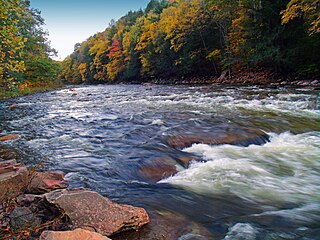
Upper Pine Bottom State Park is a 5-acre (2.0 ha) Pennsylvania state park in Lycoming County, Pennsylvania in the United States. The park is in Cummings Township on Pennsylvania Route 44 and is surrounded by the Tiadaghton State Forest. It is on Upper Pine Bottom Run, which gave the park its name and is a tributary of Pine Creek. Upper Pine Bottom State Park is in the Pine Creek Gorge, where the streams have cut through five major rock formations from the Devonian and Carboniferous periods.

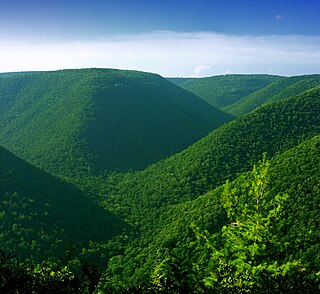
Leonard Harrison State Park is a 585-acre (237 ha) Pennsylvania state park in Tioga County, Pennsylvania, in the United States. It is on the east rim of the Pine Creek Gorge, also known as the Grand Canyon of Pennsylvania, which is 800 feet (240 m) deep and nearly 4,000 feet (1,200 m) across here. It also serves as headquarters for the adjoining Colton Point State Park, its sister park on the west rim of the gorge. Leonard Harrison State Park is known for its views of the Pine Creek Gorge, and offers hiking, fishing and hunting, whitewater boating, and camping. The park is in Shippen and Delmar Townships, 10 miles (16 km) west of Wellsboro at the western terminus of Pennsylvania Route 660.

Lyman Run State Park is a 595-acre (241 ha) Pennsylvania state park in Ulysses and West Branch Townships in Potter County, Pennsylvania in the United States. Lyman Run Lake is a 45-acre (18 ha) man-made lake within the park, surrounded by a northern hardwood forest of mainly maple and cherry trees. Lyman Run State Park is 7 miles (11 km) west of Galeton and 15 miles (24 km) east of Coudersport, and is nearly completely surrounded by the Susquehannock State Forest.
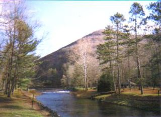
Ole Bull State Park is a 132-acre (53 ha) Pennsylvania state park in Stewardson Township, Potter County, Pennsylvania in the United States. The park is located on Pennsylvania Route 144, 26 miles (42 km) north of Renovo and 18 miles (29 km) south of Galeton. Ole Bull State Park is in the Kettle Creek Valley, and is surrounded by Susquehannock State Forest. The woods surrounding the park are called the Black Forest because of its once dense tree cover.

Prouty Place State Park is a Pennsylvania state park on 5 acres (2 ha) in Summit Township, Potter County, Pennsylvania in the United States. The park is 5 miles (8 km) southwest of Pennsylvania Route 44, along Prouty Road near the junction with Long Toe Road, near Sweden Valley. The park provides access points for hiking, hunting and fishing in the Susquehannock State Forest. It is a small rest area for hikers and other travellers to the wilds of Potter County.

Quehanna Wild Area is a wildlife area within parts of Cameron, Clearfield and Elk counties in the U.S. state of Pennsylvania; with a total area of 50,000 acres, it covers parts of Elk and Moshannon State Forests. Founded in the 1950s as a nuclear research center, Quehanna has a legacy of radioactive and toxic waste contamination, while also being the largest state forest wild area in Pennsylvania, with herds of elk. The wild area is bisected by the Quehanna Highway and is home to second growth forest with mixed hardwoods and evergreens. Quehanna has two state forest natural areas: the 1,215-acre (492 ha) M.K. Goddard/Wykoff Run Natural Area, and the 917-acre (371 ha) Marion Brooks Natural Area. The latter has the largest stand of white birch in Pennsylvania and the eastern United States.
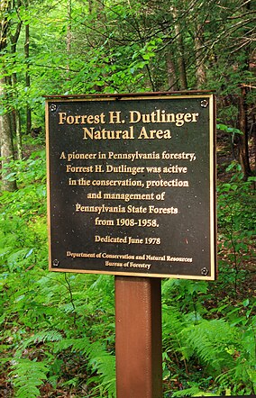
Anders Run Natural Area is a 96-acre (39 ha) protected area in Warren County, Pennsylvania, United States. It is part of Cornplanter State Forest.

Hammersley Wild Area is a 30,253-acre (12,243 ha) wild area in the Susquehannock State Forest in Potter and Clinton counties in north-central Pennsylvania in the United States. It is the largest area without a road in Pennsylvania and the state's second largest wild area. The wild area is named for Hammersley Fork, a tributary of Kettle Creek, which flows through the area. The wild area includes 10.78 miles (17.35 km) of the Susquehannock Trail System, an 83.4-mile (134.2 km) loop hiking trail almost entirely on state forest land.