
The Allegheny River is a 325-mile-long (523 km) headwater stream of the Ohio River that is located in western Pennsylvania and New York in the United States. It runs from its headwaters just below the middle of Pennsylvania's northern border, northwesterly into New York, then in a zigzag southwesterly across the border and through Western Pennsylvania to join the Monongahela River at the Forks of the Ohio at Point State Park in Downtown Pittsburgh, Pennsylvania.

McKean County is a rural county in the Commonwealth of Pennsylvania. As of the 2020 census, the population was 40,432. Its county seat is Smethport. The county was created in 1804 and organized in 1826. It was named in honor of former Pennsylvania Governor and Declaration of Independence signer Thomas McKean.

Mount Jewett is a borough in McKean County, Pennsylvania, United States. The population was 849 at the 2020 census. The students of the borough attend school in the Kane Area School District, even though the borough is surrounded by Hamlin Township—belonging to neighboring Smethport Area School District. Mount Jewett is near to the Kinzua Bridge State Park, which includes the Kinzua Bridge Sky Walk and Kinzua Viaduct. The current mayor is Brianna Howard.
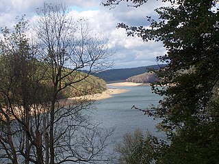
Elk State Park is a 3,192-acre (1,292 ha) Pennsylvania state park in Jones Township, Elk County and Sergeant Township, McKean County, Pennsylvania, in the United States. East Branch Clarion River Lake is a man-made lake covering 1,160 acres (470 ha) within the park. The lake and streams in the park are stocked with cold and warm water fish. There are 3,151 acres (1,275 ha) of woods open to hunting.

Allegheny Islands State Park is a 43-acre (17 ha) Pennsylvania state park in Harmar Township, Allegheny County, Pennsylvania in the United States. The undeveloped park is composed of three alluvial islands located in the middle of the Allegheny River northeast of Pittsburgh. The islands are just north of the boroughs of Oakmont and Plum, and southwest of Cheswick. Bridges for the Pennsylvania Turnpike and the Bessemer and Lake Erie Railroad Branch of the Canadian National Railway cross the Allegheny River at the middle island.

Oil Creek State Park is a Pennsylvania state park on 6,250 acres (2,529 ha) in Cherrytree, Cornplanter and Oil Creek Townships, Venango County, Pennsylvania in the United States. The park is adjacent to Drake Well Museum, the site of the first successful commercial oil well in the United States, that was drilled under the direction of Colonel Edwin Drake. Oil Creek State Park follows Oil Creek, between Titusville and Oil City, and is on Pennsylvania Route 8. While the creek is the park's main recreational attraction, it also contains the sites of the first oil boomtown and much of Pennsylvania's original oil industry. The park contains a museum, tableaux, and trails to help visitors understand the history of the oil industry there, and an excursion train.

Pennsylvania Route 68 is a 90.036-mile-long (144.899 km) east–west state highway located in western Pennsylvania in the United States. The western terminus of the route is at the Ohio state line west of Glasgow, where PA 68 continues into Ohio as State Route 39. The eastern terminus is at U.S. Route 322 in Clarion. The route runs southwest-northeast across Beaver, Butler, Armstrong, and Clarion counties. PA 68 follows the Ohio River between the Ohio border and Beaver, where it crosses the Beaver River into Rochester and heads northeast away from the Ohio River. The route runs through rural areas to Butler County, where it intersects Interstate 79 (I-79) in Zelienople before serving Evans City and Butler. PA 68 passes through a section of Armstrong County before crossing the Allegheny River into Clarion County. Here, the route passes through Rimersburg and Sligo before it has an interchange with I-80 and continues to its terminus in Clarion.
Sizerville State Park is a 386-acre (156 ha) Pennsylvania state park in Portage Township, Cameron County and Portage Township, Potter County, Pennsylvania in the United States. The park is nearly surrounded by Elk State Forest making it part of one of the largest blocks of state-owned land in Pennsylvania. Sizerville State Park is on Pennsylvania Route 155, six miles (10 km) north of the borough of Emporium.

Kinzua Creek is a 26.5-mile (42.6 km) tributary of the Allegheny River that is located in McKean County, Pennsylvania in the United States.

Bucktail State Park Natural Area is a 16,433-acre (6,650 ha) Pennsylvania state park in Cameron and Clinton Counties in Pennsylvania in the United States. The park follows Pennsylvania Route 120 for 75 miles (121 km) between Emporium and Lock Haven. Bucktail State Park Natural Area park runs along Sinnemahoning Creek and the West Branch Susquehanna River and also passes through Renovo. The park is named for the Civil War Pennsylvania Bucktails Regiment and is primarily dedicated to wildlife viewing, especially elk.
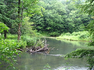
Bendigo State Park is a 100.26-acre (40.57 ha) Pennsylvania state park in Jones Township, Elk County, Pennsylvania in the United States. The park is in a valley on the East Branch Clarion River. 20 acres (8.1 ha) of the park are developed. The other 80 acres (32 ha) are undeveloped woodlands of beech, birch, cherry and maple.

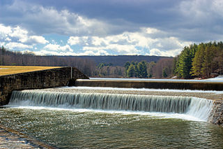
Chapman State Park is a 862-acre (349 ha) Pennsylvania state park in Pleasant Township, Warren County, Pennsylvania near Clarendon, in the United States. The man-made Chapman Lake covers 68 acres (28 ha) of the park. Chapman State Park is named in honor of Dr. Leroy E. Chapman. Dr. Chapman was a state senator from 1929 until 1963. He was part of several civic groups that pushed for the creation of a state park in Warren County. Chapman State Park, opened in 1951, is adjacent to Allegheny National Forest and State Game Land 29 just off U.S. Route 6.
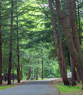
Parker Dam State Park is a 968-acre (392 ha) Pennsylvania state park in Huston Township, Clearfield County, Pennsylvania in the United States. The park is surrounded by Moshannon State Forest. Parker Dam State park is 17 miles (27 km) north of Clearfield on Pennsylvania Route 153 just off exit 111 of Interstate 80. The park was constructed during the Great Depression by the Civilian Conservation Corps; they built many of the facilities that are in use today at Parker Dam State Park.

Pennsylvania Route 321 (PA 321) is a 43.8-mile-long (70.5 km) state highway located in Elk and McKean counties in the U.S. state of Pennsylvania, maintained by the Pennsylvania Department of Transportation (PennDOT). The southern terminus is at U.S. Route 219 (US 219) in the community of Wilcox. The northern terminus is at PA 346 within the Allegheny National Forest. PA 321 heads northwest from Wilcox through rural areas to the borough of Kane, where it forms a brief concurrency with US 6. North of here, the route passes through the national forest and runs along the shore of the Allegheny Reservoir. PA 321 runs east briefly with PA 59 before winding north through more forest to its northern terminus. A portion of the route along the Allegheny Reservoir is designated as the Longhouse National Scenic Byway, a Pennsylvania Scenic Byway and National Forest Scenic Byway.

The Kinzua Bridge or the Kinzua Viaduct was a railroad trestle that spanned Kinzua Creek in McKean County in the U.S. state of Pennsylvania. The bridge was 301 feet (92 m) tall and 2,052 feet (625 m) long. Most of its structure collapsed during a tornado in July 2003.
The Northern Subdivision is a railroad line owned and operated by the Buffalo and Pittsburgh Railroad (BPRR), which is owned by Genesee and Wyoming Industries, in the U.S. state of Pennsylvania. The line is one of the oldest in Pennsylvania, and at one time, stretched all the way from Callery, to Mount Jewett, Pennsylvania. Today, more than half the line is gone.

Corydon Township is a defunct township in Warren County, Pennsylvania in the United States. The township was merged in 1964 into Mead Township.
The Pennsylvania State Game Lands Number 30 are Pennsylvania State Game Lands in McKean County in Pennsylvania in the United States providing hunting, bird watching, and other activities.

The Pennsylvania Wilds, or the Pennsylvania Wilds Conservation Landscape, is a predominantly rural and forested region in northern central Pennsylvania, mostly within the Allegheny Plateau. It covers about a quarter of the state's territory, but is home to only 4% of its population. It is one of Pennsylvania's 11 state-designated tourist regions.


