
Jay Township is a township in Elk County, Pennsylvania, United States. The population was 1,961 at the 2020 census, down from 2,072 in 2010.
Laurel Run may refer to the following places in the United States

Sinnemahoning State Park is a 1,910-acre (773 ha) Pennsylvania state park in Grove Township, Cameron County and Wharton Township, Potter County, Pennsylvania, in the United States. The park is surrounded by Elk State Forest and is mountainous with deep valleys. The park is home to the rarely seen elk and bald eagle. Sinnemahoning State Park is on Pennsylvania Route 872, eight miles (13 km) north of the village of Sinnamahoning. In 1958, the park opened under the direction of the Pennsylvania Bureau of Forestry: it became a Pennsylvania State Park in 1962.
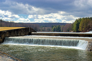
Parker Dam State Park is a 968-acre (392 ha) Pennsylvania state park in Huston Township, Clearfield County, Pennsylvania in the United States. The park is surrounded by Moshannon State Forest. Parker Dam State park is 17 miles (27 km) north of Clearfield on Pennsylvania Route 153 just off exit 111 of Interstate 80. The park was constructed during the Great Depression by the Civilian Conservation Corps; they built many of the facilities that are in use today at Parker Dam State Park.
Laurel Run is a 16.5-mile-long (26.6 km) tributary of the Bennett Branch Sinnemahoning Creek in Clearfield and Elk counties, Pennsylvania in the United States. Via the Bennett Branch, Sinnemahoning Creek, and the West Branch Susquehanna River, it is part of the Susquehanna River watershed flowing to Chesapeake Bay.
Lick Run is a tributary of the West Branch Susquehanna River in Clearfield County, Pennsylvania, in the United States. It is 11.6 miles (18.7 km) long and flows through Lawrence Township, Pine Township, and Goshen Township. Tributaries of the stream include Fork Run, Jerrys Run, and Flegals Run.
Bennett Branch Sinnemahoning Creek is a tributary of Sinnemahoning Creek in the U.S. state of Pennsylvania.
The Pennsylvania State Game Lands Number 26 are Pennsylvania State Game Lands in Bedford, Blair, Cambria, and Somerset Counties in Pennsylvania in the United States providing hunting, bird watching, equestrian, snowmobiling, and other activities.
The Pennsylvania State Game Lands Number 60 are Pennsylvania State Game Lands in Blair, Centre and Clearfield Counties in Pennsylvania in the United States providing hunting, bird watching, and other activities.
The Pennsylvania State Game Lands Number 118 are Pennsylvania State Game Lands in Blair and Huntingdon counties in Pennsylvania in the United States, providing hunting, bird watching, and other activities.
The Pennsylvania State Game Lands Number 147 are Pennsylvania State Game Lands in Blair County in Pennsylvania in the United States providing hunting, trapping, bird watching, and other activities.
The Pennsylvania State Game Lands Number 158 are Pennsylvania State Game Lands in Blair and Cambria counties in Pennsylvania in the United States, providing hunting, trapping, bird watching, and other activities.
The Pennsylvania State Game Lands Number 166 are Pennsylvania State Game Lands in Blair and Huntingdon Counties in Pennsylvania in the United States providing hunting, trapping, bird watching, and other activities.
The Pennsylvania State Game Lands Number 14 are Pennsylvania State Game Lands in Cameron, and Elk Counties in Pennsylvania in the United States providing hunting, bird watching, and other activities.
The Pennsylvania State Game Lands Number 25 are Pennsylvania State Game Lands in Elk County in Pennsylvania in the United States providing hunting, bird watching, and other activities.
The Pennsylvania State Game Lands Number 28 are Pennsylvania State Game Lands in Elk, Forest and Jefferson Counties in Pennsylvania in the United States providing hunting, bird watching, and other activities.
The Pennsylvania State Game Lands Number 29 are Pennsylvania State Game Lands in Warren Counties in Pennsylvania in the United States providing hunting, bird watching, and other activities.
The Pennsylvania State Game Lands Number 30 are Pennsylvania State Game Lands in McKean County in Pennsylvania in the United States providing hunting, bird watching, and other activities.
The Pennsylvania State Game Lands Number 31 are Pennsylvania State Game Lands in Jefferson County in Pennsylvania in the United States providing hunting, bird watching, and other activities.
The Pennsylvania State Game Lands Number 33 are Pennsylvania State Game Lands in Centre County in Pennsylvania in the United States providing hunting, bird watching, and other activities.

