Saukville is a town in Ozaukee County, Wisconsin, United States. The Village of Saukville is located in the town's southeast quadrant. The population was 1,755 at the 2000 census.

The Chequamegon–Nicolet National Forest is a 1,530,647-acre (6,194.31 km2) U.S. National Forest in northern Wisconsin in the United States. Due to logging in the early part of the 20th century, very little old growth forest remains. Some of the trees there were planted by the Civilian Conservation Corps in the 1930s. The national forest land trees and vegetation are part of the North Woods Ecoregion that prevails throughout the upper Great Lakes region.
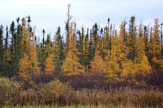
Larix laricina, commonly known as the tamarack, hackmatack, eastern larch, black larch, red larch, or American larch, is a species of larch native to Canada, from eastern Yukon and Inuvik, Northwest Territories east to Newfoundland, and also south into the upper northeastern United States from Minnesota to Cranesville Swamp, West Virginia; there is also an isolated population in central Alaska.

Big Bog State Recreation Area, a recent addition to the Minnesota state park system, is located on Minnesota State Highway 72, north of Waskish, Minnesota. It covers 9,459 acres (38.3 km2), primarily swamps, bogs, and upland "islands".
The Tannersville Cranberry Bog or Cranberry Swamp is a sphagnum bog on the Cranberry Creek in Tannersville, Pennsylvania. It is the southernmost boreal bog east of the Mississippi River, containing many black spruce and tamarack trees at the southern limit of their ranges. Technically, it can be classed as an acid fen, as it receives some groundwater flow. The site was designated a National Natural Landmark in December 1974. It was purchased by The Nature Conservancy and the Conservation and Research Foundation in 1957. Like many bogs, its terrain presents an image of solidity, but a liquid mass of decaying peat lies beneath a six-inch (152 mm) layer of sphagnum and a network of supporting tree roots. However, this bog may be viewed from a floating walkway.

The New England-Acadian forests are a temperate broadleaf and mixed forest ecoregion in North America that includes a variety of habitats on the hills, mountains and plateaus of New England and New York State in the Northeastern United States, and Quebec and the Maritime Provinces of Eastern Canada.

The Cloquet Valley State Forest encompasses 327,098 acres (1,323.7 km2); 48,384 acres (195.8 km2) of which are Minnesota Department of Natural Resources forestry administered lands.

The Cooperrider-Kent Bog State Nature Preserve is state nature preserve located mainly in Kent, Ohio. The preserve surrounds the Kent Bog, a remnant of the Wisconsin Glaciation. It is a true bog with acidic waters, and unique environmental conditions have enabled it to survive. The bog contains the largest stand of tamarack trees in the state of Ohio.

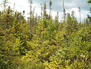
Coniferous swamps are forested wetlands in which the dominant trees are lowland conifers such as northern white cedar. The soil in these swamp areas is typically saturated for most of the growing season and is occasionally inundated by seasonal storms or by winter snow melt.
The Mid-Canada Boreal Plains Forests is a taiga ecoregion of Western Canada, designated by One Earth. It was previously defined as the Mid-Continental Canadian Forests by the World Wildlife Fund (WWF) categorization system, before it was modified by One Earth, the successor to WWF.

The Western Great Lakes forests is a terrestrial ecoregion as defined by the World Wildlife Fund. It is within the temperate broadleaf and mixed forests biome of North America. It is found in northern areas of the United States' states of Michigan, Wisconsin and Minnesota, and in southern areas of the Canadian province of Manitoba and northwestern areas of the province of Ontario.

Grandma Lake Wetlands State Natural Area is a Wisconsin Department of Natural Resources-designated State Natural Area featuring the undeveloped, pristine 44-acre Grandma Lake, which lies in a depression formed during the last glacial period. The lake is ringed by a large, open sphagnum bog mat. The bog mat is surrounded by a coniferous swamp of tamarack and black spruce. The bog mat supports a plant community that is considered diverse and unusual, with several rare species present, including: bog arrow-grass, dragon's mouth orchid, livid sedge, small-headed bog sedge, as well as one of only a few known populations of bog rush in the State of Wisconsin. In 1991, the US Forest Service designated the site as a Research Natural Area. Also, the site is listed as one of Wisconsin's Wetland Gems, by the Wisconsin Wetlands Association.

Rice Creek is a Wisconsin Department of Natural Resources-designated State Natural Area that features a large, high-quality wetland complex of conifer swamps, fens, and sedge meadows along a two-mile stretch of Rice Creek. The creek contains dense, lush beds of emergent and submergent aquatic vegetation, including wild rice. White cedar, balsam fir, black spruce, and tamarack are the dominant trees in the conifer swamp. Several stands of old-growth hemlock/hardwood forest can be found in the site, each with a supercanopy of large white pine. Two fens, fed by groundwater seepages and of exceptional floristic diversity, are found near the creek. Overall, the site supports a high concentration of rare plants and animals. At least seven species of orchid are found here: showy lady slipper, heart-leaf twayblade, swamp pink, striped coralroot, blunt-leaf orchid, northern bog orchid, and boreal bog orchid. Other notable plant species include: bog arrowgrass, naked miterwort, marsh cinquefoil, purple clematis, and downy willowherb. Notable animal species present include: barred owl, Canada jay, pine siskin, winter wren, and bog copper.

The Alfred Bog is a domed peat bog in Eastern Ontario, Canada, about 7 kilometres (4.3 mi) south of Alfred and 70 kilometres (43 mi) east of Ottawa. The bog is considered the largest high-quality bog in Southern Ontario, and was designated by the Ontario Ministry of Natural Resources as a "Class 1 Wetland" and an "Area of Natural and Scientific Interest (ANSI)" in 1984. It is home to rare animal species and a healthy moose population.

Painter Creek is a tributary of Panther Creek in Lackawanna County, Pennsylvania, in the United States. It is approximately 3.4 miles (5.5 km) long and flows through Thornhurst Township and Spring Brook Township. The watershed of the creek has an area of 4.51 square miles (11.7 km2). Wild trout naturally reproduce in the creek and a hiking trail is in its vicinity. The surficial geology in the area consists of Wisconsinan Till, bedrock, and wetlands. A bog known as the Painter Creek Bog is listed on the Lackawanna County Natural Areas Inventory.

Appalachian bogs are boreal or hemiboreal ecosystems, which occur in many places in the Appalachian Mountains, particularly the Allegheny and Blue Ridge subranges. Though popularly called bogs, many of them are technically fens.

Bontecou Lake, also known as Tamarack Swamp, is a shallow, man-made bifurcation lake in the towns of Stanford and Washington, in Dutchess County, New York, less than 5 mi (8 km) from the Village of Millbrook. Bontecou Lake straddles the drainage divide between the Wappinger Creek watershed to the west and the Tenmile River. Published estimates of its area vary between 113 acres (46 ha) and 135 acres (55 ha), placing it among the largest lakes in Dutchess County. The lake and surrounding land were protected as a nature preserve in 2022.

The Northeastern Highlands Ecoregion is a Level III ecoregion designated by the United States Environmental Protection Agency (EPA) in the U.S. states of Vermont, New Hampshire, Massachusetts, Maine, Connecticut, New York, New Jersey, and Pennsylvania. The ecoregion extends from the northern tip of Maine and runs south along the Appalachian Mountain Range into eastern Pennsylvania. Discontiguous sections are located among New York's Adirondack Mountains, Catskill Range, and Tug Hill. The largest portion of the Northeastern Highlands ecoregion includes several sub mountain ranges, including the Berkshires, Green Mountains, Taconic, and White Mountains.
Sturgeon Bay Provincial Park is a provincial park on the western shore of Lake Winnipeg in Manitoba, Canada. The park is considered to be a Class Ib protected area under the IUCN protected area management categories. It is 144.9 km2 (55.9 sq mi) in size.
Grizzly Ridge Wildland Provincial Park is a wildland provincial park in northern Alberta, Canada. The park was established on 14 April 1999 and has an area of 10,706.07 hectares. The park is included in the Upper Athabasca Region Land Use Framework.
