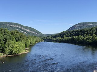
The Delaware River is a major river in the Mid-Atlantic region of the United States and is the longest free-flowing (undammed) river in the Eastern United States. From the meeting of its branches in Hancock, New York, the river flows for 282 miles (454 km) along the borders of New York, Pennsylvania, New Jersey, and Delaware, before emptying into Delaware Bay.

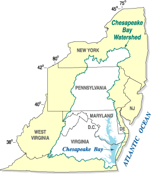
The Chesapeake Bay is the largest estuary in the United States. The Bay is located in the Mid-Atlantic region and is primarily separated from the Atlantic Ocean by the Delmarva Peninsula, including parts of the Eastern Shore of Maryland, the Eastern Shore of Virginia, and the state of Delaware. The mouth of the Bay at its southern point is located between Cape Henry and Cape Charles. With its northern portion in Maryland and the southern part in Virginia, the Chesapeake Bay is a very important feature for the ecology and economy of those two states, as well as others surrounding within its watershed. More than 150 major rivers and streams flow into the Bay's 64,299-square-mile (166,534 km2) drainage basin, which covers parts of six states and all of Washington, D.C.
New Jersey Meadowlands, also known as the Hackensack Meadowlands after the primary river flowing through it, is a general name for a large ecosystem of wetlands in northeastern New Jersey in the United States, a few miles to the west of New York City. During the 20th century, much of the Meadowlands area was urbanized, and it became known for being the site of large landfills and decades of environmental abuse. A variety of projects began in the late 20th century to restore and conserve the remaining ecological resources in the Meadowlands.

The Schuylkill River is a river in eastern Pennsylvania. It flows for 135 miles (217 km) from Pottsville southeast to Philadelphia, where it joins the Delaware River as one of its largest tributaries.

Delaware Bay is the estuary outlet of the Delaware River on the northeast seaboard of the United States, lying between the states of Delaware and New Jersey. It is approximately 782 square miles (2,030 km2) in area, the bay's freshwater mixes for many miles with the saltwater of the Atlantic Ocean.

The Hackensack River is a river, approximately 45 miles (72 km) long, in the U.S. states of New York and New Jersey, emptying into Newark Bay, a back chamber of New York Harbor. The watershed of the river includes part of the suburban area outside New York City just west of the lower Hudson River, which it roughly parallels, separated from it by the New Jersey Palisades. It also flows through and drains the New Jersey Meadowlands. The lower river, which is navigable as far as the city of Hackensack, is heavily industrialized and forms a commercial extension of Newark Bay.

Darby Creek is a tributary of the Delaware River in Chester, Delaware and Philadelphia counties, in the U.S. Commonwealth of Pennsylvania. It is approximately 26 miles (42 km) long. The watershed of the creek has an area of 77.2 square miles (200 km2). It has twelve named direct tributaries, including Cobbs Creek, Little Darby Creek, Ithan Creek, and Muckinipattis Creek. The creek has a low level of water quality for most of its length. The lower Darby Creek area was deemed a Superfund site by the U.S. Environmental Protection Agency (EPA) due to contamination with dangerous chemicals from two landfills.

The California State Coastal Conservancy is a non-regulatory state agency in California established in 1976 to enhance coastal resources and public access to the coast. The CSCC is a department of the California Natural Resources Agency. The agency's work is conducted along the entirety of the California coast, including the interior San Francisco Bay and is responsible for the planning and coordination of federal land sales to acquire into state land as well as award grant funding for improvement projects. The Board of Directors for the agency is made up of seven members who are appointed by the Governor of California and approved by the California Legislature, members of the California State Assembly and California State Senate engage and provide oversight within their legislative capacity.

Mattawoman Creek is a 30.0-mile-long (48.3 km) coastal-plain tributary to the tidal Potomac River with a mouth at Indian Head, Maryland, 20 miles (32 km) downstream of Washington, D.C. It comprises a 23-mile (37 km) river flowing through Prince George's and Charles counties and a 7-mile (11 km) tidal-freshwater estuary in Charles County. About three-fourths of its 94-square-mile (240 km2) watershed lies in Charles County, with the remainder in Prince George's County immediately to the north.
The Chesapeake Bay Program is the regional partnership that directs and conducts the restoration of the Chesapeake Bay in the United States. As a partnership, the Chesapeake Bay Program brings together members of various state, federal, academic and local watershed organizations to build and adopt policies that support Chesapeake Bay restoration. By combining the resources and unique strengths of each individual organization, the Chesapeake Bay Program is able to follow a unified plan for restoration. The program office is located in Annapolis, Maryland.
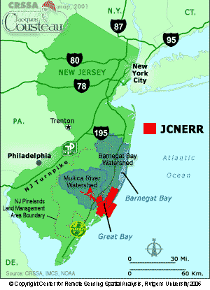
The Jacques Cousteau National Estuarine Research Reserve, located in southeastern New Jersey, encompasses over 110,000 acres (450 km2) of terrestrial, wetland and aquatic habitats within the Mullica River-Great Bay Ecosystem.

Stacy Levy is an American sculptor who works with ecological natural patterns and processes, often using water and water flows as a medium. Many of her works address environmental problems at the same time that they make the functioning of the environment visible. Her studio is based in rural Pennsylvania, but she works on projects around the world.
The Alliance for the Chesapeake Bay (Alliance) is a regional nonprofit organization that builds and fosters partnerships and consensus to protect and to restore the Chesapeake Bay and its rivers and streams. Their motto is "Together, we can get the job done!".
Citizens United to Protect the Maurice River and Its Tributaries, Inc., or "CU", is a 501(c)(3) (nonprofit) regional watershed organization. It was founded in 1979 and incorporated in 1986.

In the United States, the National Estuary Program (NEP) provides grants to states where governors have identified nationally significant estuaries that are threatened by pollution, land development, or overuse. Governors have identified a total of 28 estuaries, and the Environmental Protection Agency (EPA) awards grants to these states to develop comprehensive management plans to restore and protect the estuaries. Congress created the NEP in the 1987 amendments to the Clean Water Act.

The Philadelphia Water Department is the public water utility for the City of Philadelphia. PWD provides integrated potable water, wastewater, and stormwater services for Philadelphia and some communities in Bucks, Delaware and Montgomery counties. PWD is a municipal agency of the City of Philadelphia, and is seated in rented space at the Jefferson Tower in the Market East area of Center City, Philadelphia.
The Whippany River Watershed Action Committee (WRWAC) is a member-based, nonprofit 501(c)(3) organization, which identifies and implements projects to preserve and protect water and the surrounding natural areas. The Whippany River Watershed is an area of 69.3 square miles within Morris County in north central New Jersey. The 16-mile long Whippany River serves the only significant unconsolidated aquifer in northern New Jersey and is a source of drinking water for more than 1 million people.

The Interstate Commission on the Potomac River Basin (ICPRB) is an agency composed of commissioners representing the federal government, the states of Maryland, Pennsylvania, Virginia, West Virginia, and the District of Columbia. The ICPRB mission is to enhance, protect, and conserve the water and associated land resources of the Potomac River basin and its tributaries through regional and interstate cooperation.
The San Francisco Estuary Partnership (Partnership) is one of the 28 National Estuary Programs created in the 1987 Amendments to the Clean Water Act. The Partnership is a non-regulatory federal-state-local collaboration working to restore water quality and manage the natural resources of the San Francisco Bay-Sacramento–San Joaquin River Delta estuary. The Partnership works with over 100 municipalities, non-profits, governmental agencies, and businesses and helps develop, find funding for, and implement over 40 projects and programs aimed at improving the health of the estuary. The partnership either directly implements these projects, or administers and manages grants, holds educational workshops and highlights project results. The Partnership is also the official representative for the San Francisco Bay region to the Most Beautiful Bays in the World.
