
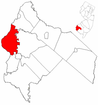
Salem County is the westernmost county in the U.S. state of New Jersey. Its western boundary is formed by the Delaware River, and it has the eastern terminus of the Delaware Memorial Bridge, which connects the county with New Castle, Delaware. Its county seat is Salem. The county is part of the South Jersey region of the state.

Route 49 is a state highway in the southern part of the U.S. state of New Jersey. It runs 53.80 mi (86.58 km) from an interchange with the New Jersey Turnpike, Interstate 295 (I-295), and U.S. Route 40 (US 40) in Deepwater, Salem County, southeast to Route 50/County Route 557 in Tuckahoe, Cape May County. The route serves Salem, Cumberland, Atlantic, and Cape May counties, passing through rural areas and the communities of Salem, Bridgeton, and Millville along the way. It is a two-lane, undivided road for most of its length.
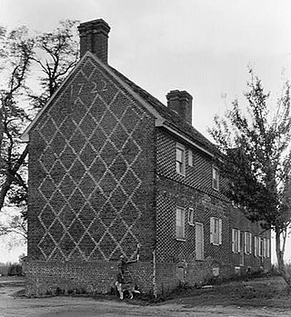
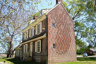
Elsinboro Township is a township in Salem County, in the U.S. state of New Jersey. As of the 2020 United States census, the township's population was 1,001, a decrease of 35 (−3.4%) from the 2010 census count of 1,036, which in turn reflected a decline of 56 (−5.1%) from the 1,092 counted in the 2000 census.
Lower Alloways Creek Township is a township in Salem County, in the U.S. state of New Jersey. As of the 2020 United States census, the township's population was 1,717, a decrease of 53 (−3.0%) from the 2010 census count of 1,770, which in turn reflected a decline of 81 (−4.4%) from the 1,851 counted in the 2000 census.
Pennsville Township is a township in Salem County, in the U.S. state of New Jersey. The township is named for William Penn. It is the westernmost town in New Jersey. As of the 2020 United States census, the township's population was 12,684, a decrease of 725 (−5.4%) from the 2010 census count of 13,409, which in turn reflected an increase of 215 (+1.6%) from the 13,194 counted in the 2000 census.

U.S. Route 130 is a U.S. Highway that is a spur route of U.S. Route 30, located completely within the state of New Jersey. It is signed with north and south cardinal directions, following a general northeast–southwest diagonal path, with north corresponding to the general eastward direction and vice versa. The route runs 83.4 mi (134.22 km) from I-295 and US 40 at Deepwater in Pennsville Township, Salem County, where the road continues south as Route 49, north to US 1 in North Brunswick, Middlesex County, where Route 171 continues north into New Brunswick. The route briefly runs concurrent with U.S. Route 30 near Camden, about one-third of the way to New Brunswick. The road runs within a close distance of I-295 south of Bordentown and a few miles from the New Jersey Turnpike for its entire length, serving as a major four- to six-lane divided local road for most of its length. US 130 passes through many towns including Penns Grove, Bridgeport, Westville, Camden, Pennsauken, Burlington, Bordentown, Hightstown, and North Brunswick.
West Jersey and East Jersey were two distinct parts of the Province of New Jersey. The political division existed for 28 years, between 1674 and 1702. Determination of an exact location for a border between West Jersey and East Jersey was often a matter of dispute.

The Salem River is a 34.7-mile-long (55.8 km) tributary of the Delaware River in southwestern New Jersey in the United States.

Finns Point is a small promontory in Pennsville Township, Salem County, New Jersey, and New Castle County, Delaware, located at the southwest corner of the cape of Penns Neck, on the east bank of the Delaware River near its mouth on Delaware Bay. Due to the wording of the original charter defining the boundaries of New Jersey and Delaware, part of the promontory is actually enclosed within the state of Delaware's border, due to tidal flow and the manner in which the borders between New Jersey and Delaware were first laid out. Therefore, this portion of Finns Point, also called The Baja, is an exclave of Delaware, cut off from the rest of the state by Delaware Bay. The area, the westernmost point in New Jersey, is about 10 miles (16 km) south of the city of Wilmington, and directly across the Delaware River from the New Castle area, and the Delaware River entrance to the Chesapeake & Delaware Canal. Pea Patch Island, part of the state of Delaware, sits in the channel of the river facing the promontory.

The Salem Nuclear Power Plant is a two-unit pressurized water reactor nuclear power plant located in Lower Alloways Creek Township, in Salem County, New Jersey, United States. It is owned by PSEG Nuclear LLC and Constellation Energy.
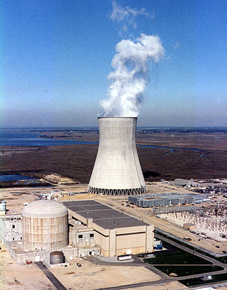
Hope Creek Nuclear Generating Station is a thermal nuclear power plant located in Lower Alloways Creek Township, in Salem County, New Jersey, United States, on the same site on Artificial Island as the two-unit Salem Nuclear Power Plant. The plant is owned and operated by PSEG Nuclear LLC. It has one unit, a boiling water reactor (BWR) manufactured by GE. The complex was designed for two units, but the second unit was cancelled in 1981. It has a generating capacity of 1,268 MWe. The plant came online on July 25, 1986, licensed to operate until 2026. In 2009, PSEG applied for a 20-year license renewal, which it received in 2011 to operate until 2046. With its combined output of 3,572 megawatts, the Salem-Hope Creek complex is the largest nuclear generating facility in the Eastern United States and the second largest nationwide, after the Palo Verde Nuclear Generating Station in Arizona.

Alloway Creek is a 23.2-mile-long (37.3 km) tributary of the Delaware River in Salem County, New Jersey in the United States. The name is a derivative of Allowas, an Indian chief. It has also been known by other names: Aloes River, Aloes Creek, Cotton River, Korten River, Short River, Monmouth River, Munmouth River, and Roiter's River.

Finn's Point National Cemetery is a United States National Cemetery located in Pennsville Township, Salem County, New Jersey, United States. It encompasses 4.6 acres (1.9 ha), and as of February 2009, had 3,033 interments. Adjacent to Fort Mott, it is governed by the United States Department of Veterans Affairs and administered by the Washington Crossing National Cemetery.

New Jersey is a state within the United States of America that lies on the north eastern edge of the North American continent. It shares a land border with the state of New York along the north, ratified by both states after the New York – New Jersey Line War, which is its only straight line border.
Border irregularities of the United States, particularly panhandles and highway incursions into other jurisdictions, are shown here. Often they are a result of borders which do not conform to geological features such as changes in the course of a river that previously marked a border.

The Finns Point Range Rear Light is a lighthouse in Pennsville Township, Salem County, New Jersey. It is located just east of the Delaware River and was part of Range light pair that guided ships into the Delaware River. It is deactivated, and its lamp and lens have been removed, but the lighthouse is open to the public as part of a National Wildlife Refuge. It was designed and built in 1877 and is a classic example of a skeletal cast iron prefabricated lighthouse. Its companion Front range light was demolished and replaced with an offshore automated light in 1938. Both the Rear and replacement Front lights were deactivated in 1950.
The Port of Paulsboro is located on the Delaware River and Mantua Creek in and around Paulsboro, in Gloucester County, New Jersey, approximately 78 miles (126 km) from the Atlantic Ocean. Traditionally one of the nation's busiest for marine transfer operations, notably for crude oil and petroleum products, such as jet fuel and asphalt, it is a port of entry with several facilities within a foreign trade zone.

The Port of Salem is a shallow-draft port in the vicinity of the Salem River Cut-Off on the Salem River in Salem, New Jersey in the United States about 2 miles (3.2 km) east of the Delaware River and about 54 miles (87 km) from the Atlantic Ocean. It was re-designated a port of entry in 1984 and became a foreign trade zone (FTZ) in 1987. Transloading operations include the handling of a variety of bulk cargo, notably of construction aggregate, break bulk cargo, and containers for clothing, fishing apparel, agricultural produce, and other consumer goods, and has at times involved lighterage. It is operated under the auspices of the South Jersey Port Corporation. The port is envisioned as being a component of the supply chain for the development of windpower in the Atlantic Ocean off the coast of New Jersey.
Ocean Wind was a proposed utility-scale 2,248 MW offshore wind farm to be located on the Outer Continental Shelf approximately 15 miles (24 km) off the coast of Atlantic City, New Jersey. It was being developed by Ørsted US Offshore Wind in conjunction with Public Service Enterprise Group (PSE&G). Construction and commissioning were planned for the mid-2020s. The closed Oyster Creek Nuclear Generating Station and B.L. England Generating Station would provide transmission points for energy generated by the wind farm.

