
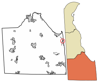
The Lewes and Rehoboth Canal is a canal in Sussex County, Delaware, which connects the Broadkill River and the Delaware Bay to Rehoboth Bay. It forms a portion of the Intracoastal Waterway.
Contents

The Lewes and Rehoboth Canal is a canal in Sussex County, Delaware, which connects the Broadkill River and the Delaware Bay to Rehoboth Bay. It forms a portion of the Intracoastal Waterway.
Originally proposed in 1803, the canal was finally constructed by the Army Corps of Engineers from 1913 to 1916. Despite its intended use as a freight shipment route, it saw little use for that purpose due to the development of more efficient roads and railways; instead, the canal has primarily been used for leisure boating for the majority of its history. [1]

The Delmarva Peninsula, or simply Delmarva, is a large peninsula on the East Coast of the United States, occupied by the vast majority of the state of Delaware and parts of the Eastern Shore regions of Maryland and Virginia. The peninsula is 170 miles (274 km) long. In width, it ranges from 70 miles (113 km) near its center, to 12 miles (19 km) at the isthmus on its northern edge, to less near its southern tip of Cape Charles. It is bordered by the Chesapeake Bay on the west, Pocomoke Sound on the southwest, and the Delaware River, Delaware Bay, and the Atlantic Ocean on the east.
U.S. Route 9 is a north–south United States highway in the states of Delaware, New Jersey, and New York in the Northeastern United States. It is one of only two U.S. Highways with a ferry connection ; the other is US 10. US 9 is signed east–west in Delaware and north–south on the rest of its route. The southern terminus of the route is in Laurel, Delaware, at an intersection with US 13, while the highway's northern terminus is at a junction with Interstate 87 (I-87) in Champlain, New York, where the roadway continues north as the unsigned NY 971B, which ends in a cul-de-sac just short of the Canadian border.

Lewes is an incorporated city on the Delaware Bay in eastern Sussex County, Delaware, United States. According to the 2010 census, the population is 2,747. Along with neighboring Rehoboth Beach, Lewes is one of the principal cities of Delaware's rapidly growing Cape Region. The city lies within the Salisbury, Maryland–Delaware Metropolitan Statistical Area. Lewes proudly claims to be "The First Town in The First State."

Dewey Beach is an incorporated coastal town in eastern Sussex County, Delaware, United States. According to the 2010 census, the population of the town is 341, an increase of 13.3% over the previous decade. It is part of the rapidly growing Cape Region and lies within the Salisbury, Maryland-Delaware Metropolitan Statistical Area. In 2011, the NRDC awarded Dewey Beach with a 5-Star rating in water quality. This award was given only to 12 other locations, one being neighboring Rehoboth Beach. Out of the 30 states with coastline, the Delaware Beaches ranked number 1 in water quality in 2011.

Fenwick Island is a coastal resort town in Sussex County, Delaware, United States. According to 2010 census figures, the population of the town is 379, a 10.8% increase over the last decade. It is part of the Salisbury, Maryland-Delaware Metropolitan Statistical Area. The town is located on Fenwick Island, a barrier spit.
Henlopen Acres is a municipality north of Rehoboth Beach in Sussex County, Delaware, United States, and is the third smallest incorporated town in Delaware. According to 2010 census figures, the population of the town is 122, a 12.2% decrease from the 2000 census. It is part of the Salisbury, Maryland-Delaware Metropolitan Statistical Area.
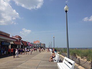
Rehoboth Beach is a city on the Atlantic Ocean along the Delaware Beaches in eastern Sussex County, Delaware, United States. As of the 2010 United States Census, the population was 1,327, reflecting a decline of 161 (11.2%) from the 1,488 counted in the 2000 Census. Along with the neighboring coastal town of Lewes, Rehoboth Beach is one of the principal cities of Delaware's rapidly growing Cape Region. Rehoboth Beach lies within the Salisbury metropolitan area.

The Cape May–Lewes Ferry is a ferry system in the United States that traverses a 17-mile (27 km) crossing of the Delaware Bay to connect North Cape May, New Jersey with Lewes, Delaware. The ferry constitutes a portion of U.S. Route 9 (US 9), and is the final crossing of the Delaware River-Delaware Bay waterway before it meets the Atlantic Ocean.

Delaware Bay is the estuary outlet of the Delaware River on the northeast seaboard of the United States. Approximately 782 square miles (2,030 km2) in area, the bay's fresh water mixes for many miles with the salt water of the Atlantic Ocean.

Cape Henlopen is the southern cape of the Delaware Bay along the Atlantic coast of the United States. It lies in the state of Delaware, near the town of Lewes, where the Delaware Bay meets the Atlantic Ocean. Off the coast on the bay side are two lighthouses, called the Harbor of Refuge Light and the Delaware Breakwater East End Light.
Delaware Route 1 (DE 1) is a 102.63-mile-long (165.17 km) state highway in the U.S. state of Delaware. The route runs from the Maryland state line in Fenwick Island, Sussex County, where the road continues south into that state as Maryland Route 528 (MD 528), north to an interchange with Interstate 95 (I-95) in Christiana, New Castle County, where the road continues north as part of DE 7. Between Fenwick Island and Dover Air Force Base in Dover, Kent County, DE 1 is a multilane divided highway with at-grade intersections and occasional interchanges. The route heads north through the Delaware Beaches resort area along the Atlantic Ocean before it runs northwest through rural areas, turning north at Milford to continue to Dover. Upon reaching Dover, DE 1 becomes the Korean War Veterans Memorial Highway, a freeway that is partially tolled. Between Dover and Tybouts Corner, DE 1 parallels U.S. Route 13 (US 13), crossing over and featuring interchanges with it multiple times. Past Tybouts Corner, the freeway heads north parallel to DE 7 to the terminus of DE 1 in Christiana. DE 1 serves as the main north-south state highway in Delaware, connecting the Delaware Beaches with the Dover and Wilmington areas.
Indian River Bay is a body of water in Sussex County, Delaware. It is part of Delaware's inland bay system, along with Little Assawoman Bay and Rehoboth Bay. Fed by the Indian River at its western end, the bay is connected to the Atlantic Ocean to the east via the Indian River Inlet. A natural waterway that shifted up and down a two-mile (3.2 km) stretch of the coast until 1928, the inlet was kept in its current location by dredging between 1928 and 1937, and in 1938 was fixed in place by the construction of jetties. The Charles W. Cullen Bridge, commonly known as the Indian River Inlet Bridge, spans the inlet.
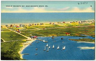
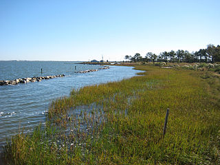
Rehoboth Bay is a body of water in Sussex County, Delaware. It is connected to the Broadkill River by the Lewes and Rehoboth Canal. It is part of Delaware's inland bay system, along with Little Assawoman Bay and Indian River Bay.
The Junction and Breakwater Trail is a 6-mile (9.7 km) long rail trail located on the southwestern side of Cape Henlopen State Park connecting Lewes and Rehoboth Beach, Delaware, United States. It is the third rail trail built in Delaware and it is the longest in the state. It partially follows the former Pennsylvania Railroad Rehoboth Beach branch that once transported passengers to several Methodist resort camps along the Atlantic coast. The line was abandoned by the Penn Central in the early 1970s.

The Queen Anne’s Railroad was a railroad that ran between Love Point, Maryland, and Lewes, Delaware, with connections to Baltimore via ferry across the Chesapeake Bay. The Queen Anne's Railroad company was formed in Maryland in 1894, and received legislative authorization from Delaware in February 1895. The railroad's original western terminus was in Queenstown, Maryland, and was moved via a 13-mile (21 km) extension to Love Point in 1902, which shortened the ferry trip to Baltimore.
Lewes & Rehoboth Hundred is a hundred in Sussex County, Delaware, United States. Lewes & Rehoboth Hundred was formed in 1692 as one of the original Delaware Hundreds. Its primary community is Lewes.
Carpenters Corner, Delaware is a village two miles south of Lewes and four miles northwest of Rehoboth Beach in Sussex County, at 38°44′30″N75°09′00″W. The village is located on Delaware Route 1, and is named for two prosperous dairy farmers.
The Cape Henlopen Region, or the Cape Region, is a region in Sussex County, in southern Delaware, on the Delmarva Peninsula. The region is part of the Salisbury, Maryland-Delaware Metropolitan Statistical Area. The region takes its name from Cape Henlopen, as does the Cape Henlopen School District and Cape Henlopen State Park. Much of the region's populated areas are found along the Delaware Bay, Rehoboth Bay and the Atlantic Ocean. Northern and western parts of the Cape Region are rural areas dominated by farmland and wetlands. The area is often referred to as the Delaware Beaches.
Beebe Healthcare is a healthcare system serving Sussex County in southern Delaware in the United States. Its primary facility is Beebe Medical Center, a hospital in Lewes.
Coordinates: 38°45′27″N75°06′34″W / 38.75750°N 75.10944°W
| | This Delaware state location article is a stub. You can help Wikipedia by expanding it. |