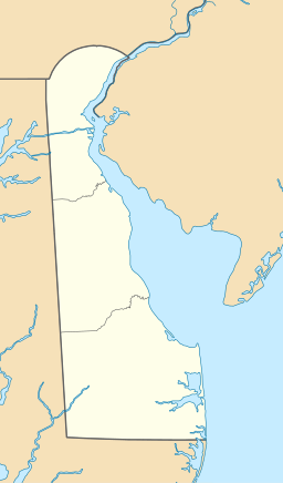
Sussex County is a county in the southern part of the U.S. state of Delaware, on the Delmarva Peninsula. As of the 2020 census, the population was 237,378, making it the state's second most populated county only behind New Castle and ahead of Kent. The county seat is Georgetown.

Lewes is an incorporated city on the Delaware Bay in eastern Sussex County, Delaware, United States. According to the 2020 census, its population was 3,303. Along with neighboring Rehoboth Beach, Lewes is one of the principal cities of Delaware's rapidly growing Cape Region. The city lies within the Salisbury, Maryland–Delaware Metropolitan Statistical Area. Lewes proudly claims to be "The First Town in The First State."

Dewey Beach is an incorporated coastal town in eastern Sussex County, Delaware, United States. According to the 2010 census, the population of the town is 341, an increase of 13.3% over the previous decade. It is part of the rapidly growing Cape Region and lies within the Salisbury, Maryland-Delaware Metropolitan Statistical Area. In 2011, the NRDC awarded Dewey Beach with a 5-Star rating in water quality. This award was given only to 12 other locations, one being neighboring Rehoboth Beach. Out of the 30 states with coastline, the Delaware Beaches ranked number 1 in water quality in 2011.

Fenwick Island is a coastal resort town in Sussex County, Delaware, United States. According to 2020 census figures, the population of the town is 355, a 2.6% decrease over the last decade. It is part of the Salisbury, Maryland–Delaware Metropolitan Statistical Area. The town is located on Fenwick Island, a barrier spit.
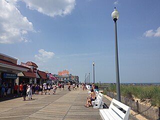
Rehoboth Beach is a city on the Atlantic Ocean along the Delaware Beaches in eastern Sussex County, Delaware, United States. As of 2020, its population was 1,108. Along with the neighboring coastal town of Lewes, Rehoboth Beach is one of the principal cities of Delaware's rapidly growing Cape Region. Rehoboth Beach lies within the Salisbury metropolitan area.

South Bethany is an incorporated town in Sussex County, Delaware, United States. According to the 2010 census, the population of the town is 449, a decrease of 8.7% over the previous decade. It is part of the Salisbury, Maryland-Delaware Metropolitan Statistical Area.

The Intracoastal Waterway (ICW) is a 3,000-mile (4,800 km) inland waterway along the Atlantic and Gulf of Mexico coasts of the United States, running from Massachusetts southward along the Atlantic Seaboard and around the southern tip of Florida, then following the Gulf Coast to Brownsville, Texas. Some sections of the waterway consist of natural inlets, saltwater rivers, bays, and sounds, while others are artificial canals. It provides a navigable route along its length without many of the hazards of travel on the open sea.

The Broadkill River is a river flowing to Delaware Bay in southern Delaware in the United States. It is 13.3 miles (21.4 km) long and drains an area of 110 square miles (280 km2) on the Atlantic Coastal Plain.

Delaware Route 1 (DE 1) is the longest numbered state highway in the U.S. state of Delaware. The route runs 102.63 mi (165.17 km) from the Maryland state line in Fenwick Island, Sussex County, where the road continues south into that state as Maryland Route 528 (MD 528), north to an interchange with Interstate 95 (I-95) in Christiana, New Castle County, where the roadway continues north as part of DE 7. Between Fenwick Island and Dover Air Force Base in Dover, Kent County, DE 1 is a multilane divided highway with at-grade intersections and occasional interchanges. The route heads north through the Delaware Beaches resort area along the Atlantic Ocean before it runs northwest through rural areas, turning north at Milford to continue to Dover. Upon reaching Dover, DE 1 becomes the Korean War Veterans Memorial Highway, a freeway that is partially tolled. Between Dover and Tybouts Corner, DE 1 parallels U.S. Route 13 (US 13), crossing over and featuring interchanges with it multiple times. Past Tybouts Corner, the freeway heads north parallel to DE 7 to the northern terminus of DE 1 in Christiana. DE 1 serves as the main north-south state highway in Delaware, connecting the Delaware Beaches with the Dover and Wilmington areas.
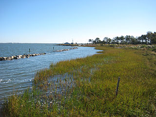
Indian River Bay is a body of water in Sussex County, Delaware. It is part of Delaware's inland bay system, along with Little Assawoman Bay and Rehoboth Bay. Fed by the Indian River at its western end, the bay is connected to the Atlantic Ocean to the east via the Indian River Inlet. A natural waterway that shifted up and down a two-mile (3.2 km) stretch of the coast until 1928, the inlet was kept in its current location by dredging between 1928 and 1937, and in 1938 was fixed in place by the construction of jetties. The Charles W. Cullen Bridge, commonly known as the Indian River Inlet Bridge, spans the inlet.
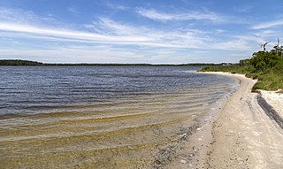
Little Assawoman Bay is a body of water in Sussex County, Delaware. It is connected from Assawoman Bay to the south by a narrow canal known locally as "The Ditch," and is connected to Indian River Bay to the north by the Assawoman Canal. It is separated from the Atlantic Ocean by the Fenwick Island barrier spit.
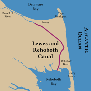
The Lewes and Rehoboth Canal is a canal in Sussex County, Delaware, which connects the Broadkill River and the Delaware Bay to Rehoboth Bay. It forms a portion of the Intracoastal Waterway.

Delaware Seashore State Park is located near Dewey Beach, in Delaware, United States. It is bounded on the east by the Atlantic Ocean and on the west by Rehoboth Bay and Indian River Bay. The park covers 2,825 acres (1,143 ha). It is a major attraction for millions of visitors who come to the Delaware Beaches for water-related activities. Delaware Seashore State Park was created in 1965.
Maryland Route 54 (MD 54) and Delaware Route 54 (DE 54) are adjoining state highways in the U.S. states of Maryland and Delaware. Route 54 runs 41.84 mi (67.33 km) from MD 313 in Mardela Springs, Maryland, east to DE 1 in Fenwick Island, Delaware. In addition to two segments in which the highway is completely in Delaware and two segments in which the highway is completely in Maryland, Route 54 follows the Delaware/Maryland state line between the twin towns of Delmar, Maryland, and Delmar, Delaware, and the highway's intersection with MD 353 and DE 26. One section of the state line portion of Route 54 is maintained by the Delaware Department of Transportation (DelDOT) while three sections of the highway that follow the state line are maintained by the Maryland State Highway Administration (MDSHA).

Delaware Route 26 (DE 26) is a state highway in Sussex County, Delaware. The route's western terminus is at an intersection with Maryland Route 353 (MD 353) and DE/MD 54 at the Maryland border south of Gumboro and its eastern terminus is at a dead end on the Atlantic Ocean in Bethany Beach, even though signage ends at the DE 1 intersection. The route passes through rural areas of southeastern Sussex County along with the communities of Dagsboro, Millville, Ocean View and Bethany Beach. DE 26 intersects DE 54 in the Gumboro area, U.S. Route 113 (US 113) and DE 20 in Dagsboro, and DE 17 west of Millville. The road was built as a state highway in various stages during the 1920s and 1930s. By 1936, DE 26 was assigned onto its current alignment.
Delaware Bicycle Route 1 is a bicycle route that runs the north-south length of the U.S. state of Delaware, from the Maryland border in Fenwick Island, Sussex County north to the Pennsylvania border near Montchanin, New Castle County. The route passes through many Delaware scenes, including beaches, farmland, state parks, and towns. The route is the first of many signed bike routes planned in the state.

The Cape Henlopen Region, or the Cape Region, is a region in Sussex County, in southern Delaware, on the Delmarva Peninsula. The region is part of the Salisbury, Maryland-Delaware Metropolitan Statistical Area. The region takes its name from Cape Henlopen, as does the Cape Henlopen School District and Cape Henlopen State Park. Much of the region's populated areas are found along the Delaware Bay, Rehoboth Bay and the Atlantic Ocean. Northern and western parts of the Cape Region are rural areas dominated by farmland and wetlands. The area is often referred to as the Delaware Beaches.
Assawoman Wildlife Area is a state wildlife area located in Sussex County, Delaware located near Frankfort, Delaware and Little Assawoman Bay. It is made up of three large tracts of land that total 3,100 acres (1,300 ha) that were originally former farms that were lost due to the Great Depression, and managed by the Delaware Department of Natural Resources and Environmental Control (DNREC). The wildlife areas name came from the nearby Little Assawoman Bay which was originally named Assateague, an Algonkian word meaning "stream or inlet in the middle" before it was changed to another Algonkian name which means "midway fishing stream."