
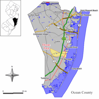
Lacey Township is a township in Ocean County, New Jersey and is considered part of the Jersey Shore and South Jersey regions. As of the 2010 United States Census, the township's population was 27,644, reflecting an increase of 2,298 (+9.1%) from the 25,346 counted in the 2000 Census, which had in turn increased by 3,205 (+14.5%) from the 22,141 counted in the 1990 Census. The 2010 population was the highest recorded in any decennial census. It was named for Continental Army General John Lacey.
Ocean Township is a township in Ocean County, New Jersey, United States. As of the 2010 United States Census, the township's population was 8,332, reflecting an increase of 1,882 (+29.2%) from the 6,450 counted in the 2000 Census, which had in turn increased by 1,034 (+19.1%) from the 5,416 counted in the 1990 Census. The 2010 population was the highest recorded in any decennial census.

The New Jersey Pine Barrens, also known as the Pinelands or simply the Pines, is the largest remaining example of the Atlantic coastal pine barrens ecosystem, stretching across more than seven counties of New Jersey. Two other large, contiguous examples of this ecosystem remain in the northeastern United States: the Long Island Central Pine Barrens and the Massachusetts Coastal Pine Barrens. The name pine barrens refers to the area's sandy, acidic, nutrient-poor soil. Although European settlers could not cultivate their familiar crops there, the unique ecology of the Pine Barrens supports a diverse spectrum of plant life, including orchids and carnivorous plants. The area is also notable for its populations of rare pygmy pitch pines and other plant species that depend on the frequent fires of the Pine Barrens to reproduce. The sand that composes much of the area's soil is referred to by the locals as sugar sand.

Washington Crossing State Park is a 3,575-acre (14 km2) New Jersey state park that is part of Washington's Crossing, a U.S. National Historic Landmark area. It is located in the Washington Crossing and Titusville sections of Hopewell Township in Mercer County, north of Trenton along the Delaware River. The park is operated and maintained by the New Jersey Division of Parks and Forestry. It is supported by the Washington Crossing Park Association, a friends group that works to preserve, enhance, and advocate for the park.

South Jersey comprises the southern portion of the U.S. state of New Jersey, between the lower Delaware River and the Atlantic Ocean. The designation of southern New Jersey with a distinct toponym is a colloquial one rather than an administrative one, reflecting not only geographical but also perceived cultural differences from the northern part of the state, with no official definition. Though definitions of South Jersey may vary, most of South Jersey is generally considered to be part of the Philadelphia Metropolitan Area.

The Brendan T. Byrne State Forest is a 37,242 acres (150.71 km2) state forest in the New Jersey Pine Barrens. Its protected acreage is split between Burlington and Ocean Counties.
Monmouth Battlefield State Park is a 1,818-acre (7.36 km2) New Jersey state park located on the border of Manalapan and Freehold Township, in Monmouth County, New Jersey, United States. This park preserves the historical battlefield on which the American Revolutionary War's Battle of Monmouth (1778) was waged.
Bayville is an unincorporated community located within Berkeley Township in Ocean County, New Jersey, United States. The area is served as United States Postal Service ZIP Code 08721. As of the 2010 United States Census, the population for ZIP Code Tabulation Area (ZCTA) 08721 was 20,512. Central Regional High School is the local high school for the area.

Mauricetown is an unincorporated community located within Commercial Township in Cumberland County, New Jersey.

Capt. John Jeffries Burial Marker is an historic burial monument in the cemetery at Scullville Bible Church in Egg Harbor Township, New Jersey, along County Route 559 near Somers Point. It was built in 1887 and added to both the New Jersey Register of Historic Places and the National Register of Historic Places in 1984.

Ocean City Tenth Street Station is located in Ocean City, Cape May County, New Jersey, United States. Built in 1898, it served rail service until 1981. The building now operates as the Ocean City Transportation Center, which is a bus stop for NJ Transit.

Droescher's Mill is located in Cranford, Union County, New Jersey, United States. The mill was added to the National Register of Historic Places on January 8, 1974. It is the oldest continuously operated commercial building in New Jersey.
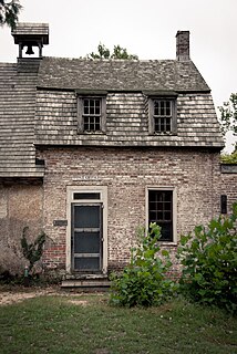
Batsto Village is a historic unincorporated community located on CR 542 within Washington Township in Burlington County, New Jersey, United States. It is located in Wharton State Forest in the south central Pine Barrens, and a part of the Pinelands National Reserve. It is listed on the New Jersey and National Register of Historic Places, and is administered by the New Jersey Department of Environmental Protection's Division of Parks & Forestry. The name is derived from the Swedish bastu, bathing place ; the first bathers were probably the Lenni Lenape Native Americans.

Rancocas is an unincorporated community located within Westampton Township in Burlington County, New Jersey. The name derives from the Native American word Rankokous. which was used in the name of the Powhatan Lenape Nation Indian Reservation located in Westampton Township. The name was also known as a sub-tribe of the Ancocus. The Reservation was a popular tourist destination for visitors from the Philadelphia area, New York, and local residents, before the Reservation became Rancocas State Park.

The Road Up Raritan Historic District is a 69-acre (28 ha) historic district located along River Road in the township of Piscataway in Middlesex County, New Jersey. It is north of Raritan Landing, once an important inland port on the Raritan River during the 18th and 19th centuries. The name is taken from an earlier colonial era name for what was once a Lenape path, Assunpink Trail that became a main road parallel to the river. Piscataway Township itself was formed on December 18, 1666 as one of the first seven townships in East Jersey, and is one of the oldest municipalities in the state. It was added to the National Register of Historic Places on September 18, 1997, for its significance in architecture, military history, and exploration/settlement. The district includes nine of fourteen historic homes along an approximately 1.2-mile (1.9 km) stretch of River Road. The Metlar-Bodine House and the Cornelius Low House are also in the immediate vicinity.

Arneytown is an unincorporated community located along Province Line Road on the border of North Hanover Township in Burlington County and Upper Freehold Township in Monmouth County of New Jersey. It is two miles (3.2 km) north of Jacobstown. Province Line Road was on the boundary line between the Provinces of East Jersey and West Jersey. The area was once called Upper Freehold by 18th-century Quaker settlers. With the establishment of the first post office in 1827, it became known as Arneytown.

Readingsburg, also known as Stone Mill, is an unincorporated community located along the South Branch Raritan River within Clinton Township in Hunterdon County, New Jersey.

Green Bank is an unincorporated community located within Washington Township, in Burlington County, New Jersey, United States. It is located on the Mullica River.

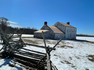
The Cedar Bridge Tavern is a historic building located in the New Jersey Pine Barrens in Barnegat Township. It was built around 1740 and is believed to be the oldest intact bar in the United States. It is located at the site of the last skirmish of the American Revolutionary War. It is on the National Register of Historic Places.

The Beach Haven Historic District is a historic district in Beach Haven, Ocean County, New Jersey. The district was added to the National Register of Historic Places on July 14, 1983 for its significance in architecture and history as a beach-front resort during the 19th century. The district boundary was increased on November 19, 2014. It now includes 149 contributing buildings.


