
Brady Township is a township in Clearfield County, Pennsylvania, United States. The population was 1,942 at the 2020 census.

Clearfield is a borough and the county seat of Clearfield County, Pennsylvania, United States. As of the 2020 census the population was 5,962 people, making it the second most populous community in Clearfield County, behind DuBois. The borough is part of the DuBois, PA Micropolitan Statistical Area, as well as the larger State College-DuBois, PA Combined Statistical Area. The settled area surrounding the borough consists of the nearby census-designated places of Hyde and Plymptonville, which combined with Clearfield have a population of approximately 8,237 people.

Smicksburg is a borough in Indiana County, Pennsylvania, United States. The population was 57 at the 2020 census, and it is one of the smallest incorporated boroughs in Pennsylvania. It was founded by the Reverend J. George Schmick.

Reynoldsville is a borough in Jefferson County, Pennsylvania, United States. It is 73 miles (117 km) northeast of Pittsburgh in a productive soft coal region. The population was 2,759 at the 2010 census.

The Susquehanna River is a major river located in the Mid-Atlantic region of the United States, overlapping between the lower Northeast. At 444 miles (715 km) long, it is the longest river on the East Coast of the United States. By watershed area, it is the 16th-largest river in the United States, and also the longest river in the early 21st-century continental United States without commercial boat traffic.

The West Branch Susquehanna River is one of the two principal branches, along with the North Branch, of the Susquehanna River in the Northeastern United States. The North Branch, which rises in upstate New York, is generally regarded as the extension of the main branch, with the shorter West Branch being its principal tributary.

French Creek is a tributary of the Allegheny River in northwestern Pennsylvania and western New York in the United States.

Shamokin was a multi-ethnic Native American trading village on the Susquehanna River, located partially within the limits of the modern cities of Sunbury and Shamokin Dam, Pennsylvania. It should not be confused with present-day Shamokin, Pennsylvania, located to the east. The village was the focus of missionary efforts, and then was the staging area for raids on English settlements in Pennsylvania during the French and Indian War. It was burned and abandoned by the Lenape in May, 1756. A few months later, Fort Augusta was constructed on the site of the village.

Anderson Creek is a 23.6-mile-long (38.0 km) tributary of the West Branch Susquehanna River in Clearfield County, Pennsylvania, in the United States.
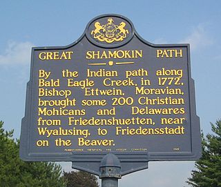
The Great Shamokin Path was a major Native American trail in the U.S. State of Pennsylvania that ran from the native village of Shamokin along the left bank of the West Branch Susquehanna River north and then west to the Great Island. There it left the river and continued further west to Chinklacamoose and finally Kittanning on the Allegheny River.

Culbertson's Path was a Native American trail in north central Pennsylvania in the United States, which connected the Great Island Path with the Sheshequin Path. The eastern / southern end of the path was on the West Branch Susquehanna River at what is now the village of Allenwood in Gregg Township, Union County. The northern / western end was in Old Lycoming Township just north of what is now the city of Williamsport in Lycoming County.
Fort Augusta was a stronghold in Northumberland County, Pennsylvania, in the upper Susquehanna Valley from the time of the French and Indian War to the close of the American Revolution.

The Great Indian Warpath (GIW)—also known as the Great Indian War and Trading Path, or the Seneca Trail—was that part of the network of trails in eastern North America developed and used by Native Americans which ran through the Great Appalachian Valley. The system of footpaths extended from what is now upper New York to deep within Alabama. Various Native peoples traded and made war along the trails, including the Catawba, numerous Algonquian tribes, the Cherokee, and the Iroquois Confederacy. The British traders' name for the route was derived from combining its name among the northeastern Algonquian tribes, Mishimayagat or "Great Trail", with that of the Shawnee and Delaware, Athawominee or "Path where they go armed".

The Pine Creek Path was a major Native American trail in the U.S. State of Pennsylvania that ran north along Pine Creek from the West Branch Susquehanna River near Long Island to the headwaters of the Genesee River.

The Bald Eagle Creek Path was a major Native American trail in the U.S. State of Pennsylvania that ran from the Great Island on the West Branch Susquehanna River southwest to what is now the village of Frankstown on the Frankstown Branch Juniata River. The path ran from Clinton County southwest through Centre County and a small part of Blair County to its southern end in Blair County. It was part of a "Warriors Path", an important connector between paths leading to New York and the Six Nations of the Iroquois and the Ohio River country in the north and west, and paths leading to what are now Maryland, Virginia, and the Carolinas in the south.
Bilger's Rocks is a park in Clearfield County, Pennsylvania, USA, near the town of Grampian in Bloom Township. The surrounding area is intricately laced with hills, mountains, and river valleys that generally follow the Appalachian mountain range in a northwest to southeast direction. The area of the park is located along the Allegheny section of the mountains, approximately 8 miles (13 km) southwest of the highest point on Interstate 80 east of the Mississippi River.
The Goschgoschink Path, later known as Mead's Path, begins at the junction of the Great Shamokin Path at The Big Spring near Luthersburg, Brady Township, Clearfield County, Pennsylvania. The path then proceeds to Thunderbird Spring, Sandy Valley Station, north of Reynoldsville, Jefferson County, thence through the Horme Settlement and slightly north of Emerickville to Brookville; north of Clarion, to West Hickory, Pennsylvania, in Forest County and the Allegheny River. From here, travelers could journey to Fort Le Boeuf and Lake Erie.
Nemacolin was a hereditary chief of the Delaware Nation who helped Thomas Cresap widen a Native American path across the Allegheny Mountains to the Ohio River Valley.
The Pennsylvania State Game Lands Number 30 are Pennsylvania State Game Lands in McKean County in Pennsylvania in the United States providing hunting, bird watching, and other activities.
