Cumbernauld Village

Last updated

The Spur Hotel, Cumbernauld Village The Spur Hotel, village of Cumbernauld (geograph 1833210).jpg
The Spur Hotel, Cumbernauld Village
Churchyard, Cumbernauld Old Parish Church Churchyard, Cumbernauld Old Parish Church - geograph.org.uk - 530191.jpg
Churchyard, Cumbernauld Old Parish Church
The Lang Riggs The Lang Riggs, Village of Cumbernauld (geograph 1833191).jpg
The Lang Riggs

Cumbernauld Village (often referred to locally as just the Village) is an area of Cumbernauld. Whilst Cumbernauld was designated a new town in 1955, the Village itself has a pre-mediaeval history, with a Roman settlement being built in the area due to its proximity to the Antonine Wall. After the Roman period the settlement remained and grew to such an extent that the Comyn family built their chapel there. It is recorded that, in 1500, the Black Death led to a special plea from the surviving people of Cumbernauld to the church authorities in Glasgow to allow them to establish their own cemetery rather than taking all their dead to St. Ninian's in Kirkintilloch. [1] This source is also quoted in "Excavations at 3-11 Main Street, Cumbernauld". [2] The villagers were granted permission to do so, and used the ground at the existing Comyns' chapel which dates from the end of the 12th century. Farming in long strips or Lang Riggs was carried out in the village. [3]

Contents

The Flemings (who would become the Earls of Wigtown) later took over the Comyns' castle in Cumbernauld. In the 18th century this was replaced by Cumbernauld House

The Wynd with a pend rather than an early underpass and pavements beside the road The Wynd, Cumbernauld (geograph 2647228).jpg
The Wynd with a pend rather than an early underpass and pavements beside the road
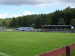
Guy's Meadow Cumbernauld United Football Club - geograph.org.uk - 221808.jpg
Guy's Meadow

By the 17th century the main industry of the Village was hand loom weaving, but this subsequently changed as due to the village's proximity to the Forth and Clyde canal and rich source of natural minerals and stone it became a site of mining and quarrying. The Village was also the site of a number of tenant held farms on the Flemings' estate. The 19th century Groome's Gazetteer states [4] that Cumbernauld is: "A picturesque old place, sheltered to E and SE by the grounds of Cumbernauld House, it was created a burgh of barony in 1649, and has a post office under Glasgow, a branch of the Royal Bank, a local savings' bank, 2 chief inns, gas-works, many new handsome villas, and a cattle-fair on the second Thursday of May. The parish church here is an old building, containing 660 sittings; the Free church dates from 1826, having belonged to the Original Secession, but has been lately almost rebuilt; and there is also a new U.P. church. Handloom weaving of checks and other striped fabrics is still carried on, but mining and quarrying are the staple industry. Pop. (1861) 1561, (1871) 1193, (1881) 1064."

Cumbernauld had one of the oldest curling societies in the world which was established in the 18th century. [5] The curling pond was near the Spur Inn, on the other side of the Bog Stank [6] to the village. [7]

October 1878 was a difficult time locally made worse by the failure of the Bank of Glasgow in which much of the village's money was invested. As the mining industry declined the village was further boosted by the decision to site a new town in the vicinity, with Cumbernauld lending its name to this new town.

Today

Looking North from Wilderness Brae to entrance to Village near old curling pond Looking North from Wilderness Brae - geograph.org.uk - 1762453.jpg
Looking North from Wilderness Brae to entrance to Village near old curling pond
Pebbled Monster Pebbled Monster (geograph 1885119).jpg
Pebbled Monster

Today, Cumbernauld Village is quite characteristically different from most of the rest of the town, as it contains a high number of local amenities, and its structure of having pavements beside the roads in the Village is quite unlike the rest of the planned new town, with the possible exception of Condorrat which, like Cumbernauld Village, is a settlement of many years' standing before the new town's construction.

Cumbernauld Village has an active local community and local people are involved in the Village Community Council and in Cumbernauld Village Action for the Community. The latter is a community group campaigning for improvements to the amenity of the Village.

Cumbernauld United FC

Cumbernauld's non-league (junior) football team, Cumbernauld United, play in the Village at Guy's Meadow. Cumbernauld United also have a full youth academy with teams at all age groups from under 6 upwards, considered by many as one of the best in Central Scotland. All of United's teams play on the main Guy's Meadow pitch or on the impressive Astroturf facility which surrounds the stadium: Hat-Trix soccer complex.

Currently SJFA West Region Premiership (a division above United) side Kirkintilloch Rob Roy are ground-sharing at Guy's Meadow.

See also

Related Research Articles

Bishopbriggs Town in Scotland

Bishopbriggs ; Scottish Gaelic: Drochaid an Easbaig) is a town in East Dunbartonshire, Scotland. It lies on the northern fringe of Greater Glasgow, approximately 4 miles (6 km) from the city centre. Historically in Lanarkshire, the area was once part of the historic parish of Cadder - originally lands granted by King William the Lion to the Bishop of Glasgow, Jocelin, in 1180. It was later part of the county of Lanarkshire, and then an independent burgh from 1964 to 1975. Today, Bishopbriggs' close geographic proximity to Glasgow now effectively makes it a suburb and commuter town of the city. The town's original Gaelic name Coille Dobhair reflects the name of the old parish of Cadder, but modern Gaelic usage uses Drochaid an Easbaig, a literal translation of Bishopbriggs. It was ranked the 2nd most desirable postcode in Scotland to live in following a study by the Centre for Economic and Business Research in 2015 and 2016.

Dunbartonshire Historic county in Scotland

Dunbartonshire or the County of Dumbarton is a historic county, lieutenancy area and registration county in the west central Lowlands of Scotland lying to the north of the River Clyde. Dunbartonshire borders Perthshire to the north, Stirlingshire to the east, Lanarkshire and Renfrewshire to the south, and Argyllshire to the west. The boundaries with Lanarkshire and Stirlingshire are split in two owing to the existence of an exclave around Cumbernauld.

Cumbernauld United F.C. Association football club in Scotland

Cumbernauld United Football Club are a football club based in Cumbernauld, North Lanarkshire, Scotland. They play at Guy's Meadow in the Cumbernauld Village area of the town.

Kilsyth Human settlement in Scotland

Kilsyth is a town and civil parish in North Lanarkshire, roughly halfway between Glasgow and Stirling in Scotland. The estimated population is 9,860. The town is famous for the Battle of Kilsyth and the religious revivals of the 18th, 19th, and 20th centuries. The town now has links with Cumbernauld at one time being part of Cumbernauld and Kilsyth District Council. The towns also have the same members of parliament at Holyrood and Westminster.

Kirkintilloch Human settlement in Scotland

Kirkintilloch is a town and former barony burgh in East Dunbartonshire, Scotland. It lies on the Forth and Clyde Canal and on the south side of Strathkelvin, about 8 miles (13 km) northeast of central Glasgow. Historically part of Dunbartonshire, the town is the administrative home of East Dunbartonshire council area, its population in 2009 was estimated at 19,700 and its population in 2011 was 19,689.

Kirkintilloch Rob Roy F.C. Association football club in Scotland

Kirkintilloch Rob Roy Football Club are a Scottish football club based in the town of Kirkintilloch, East Dunbartonshire. Nicknamed The Rabs or The Roy, they were formed in 1878. They wear red and black strips and currently compete in the West of Scotland League Premier Division.

Condorrat Human settlement in Scotland

Condorrat is a former village in North Lanarkshire, Scotland. Like Luggiebank, Castlecary and Dullatur, it predates the new town of Cumbernauld, but unlike those Condorrat was officially included in the designated new town area. Since then it has officially been part of Cumbernauld although it retains some of its own distinctive character. Dalshannon Farm and cottages were located in the area west of the original town and farm, and north of the Luggie. So also was a corn mill called Wood Mill. Road signs show they are is now in the western part of Condorrat towards Mollinsburn.

Lenzie Human settlement in Scotland

Lenzie is an affluent town by the Edinburgh and Glasgow Railway in the East Dunbartonshire council area of Scotland. It is about 6 miles (10 km) north-east of Glasgow city centre and 1 mile (2 km) south of Kirkintilloch. At the 2011 census, it had a population of 8,873. The ancient barony of Lenzie was held by William de Comyn, Baron of Lenzie and Lord of Cumbernauld in the 12th century.

Twechar Human settlement in Scotland

Twechar is a small former mining village historically in Dunbartonshire and administered by the council area of East Dunbartonshire, Scotland close to the boundary with North Lanarkshire. It lies between the larger towns of Cumbernauld, Kilsyth and Kirkintilloch. The Forth and Clyde Canal runs close to the village to the north, and closely follows the line of the Antonine Wall. There are visible remains of the wall on Bar Hill and the Roman Fort is a local tourist attraction.

Auchinloch Village in North Lanarkshire, Scotland

Auchinloch is a village in Scotland, situated within the North Lanarkshire local authority area but very close to the boundary with East Dunbartonshire and sharing the G66 postcode of the town of Kirkintilloch and the adjoining village of Lenzie, located a short distance to the north. Other nearby settlements in North Lanarkshire are Stepps to the south and Chryston to the south-east, each approximately 1.3 miles (2.1 km) away across farmland and on the opposite side of the M80 motorway; the City of Glasgow boundary and the suburb of Robroyston is about the same distance to the west. In previous years Auchinloch was in the Parish of Cadder and, from 1975 until 1996, the district of Strathkelvin within Strathclyde Region.

Holytown is a village situated to the east of Bellshill and north of Motherwell in North Lanarkshire, Scotland. Most local amenities are shared with the adjacent villages of Carfin, Newarthill and New Stevenston which have a combined population of around 20,000 across the four localities.

Dullatur Human settlement in Scotland

Dullatur is a village near Cumbernauld, Scotland. Like Condorrat, Castlecary and Luggiebank, it predates the new town of Cumbernauld, and of those only Condorrat was officially included in the designated area. Its name is anglicised from the Gaelic Dubh Leitir, which means "dark slope". The route of the Antonine Wall passes just to the north of Dullatur. Two Roman temporary marching camps were located at Dullatur between the forts at Croy Hill and Westerwood. The camps have been excavated several times by archaeologists following aerial photography and proposed housebuilding. Both camps have now been built over, and no visible remains can be seen on the ground today. Digital reconstructions of the larger and the smaller of the camps have been created. When building the nearby Forth and Clyde Canal in the 18th century a number of finds were made in Dullatur Bog. Thomas Watson recorded: "a number of swords, pistols, and other weapons were dug out; also the bodies of men and horses, and what seems somewhat marvellous, a trooper, completely armed, and seated on his horse, in the exact posture in which he had perished." It was supposed that the man was escaping the Battle of Kilsyth which is due north of Dullatur Bog.

Stepps is a settlement in North Lanarkshire, Scotland, near the north-eastern outskirts of Glasgow. Its recently upgraded amenities include a new primary school, library and sports facilities. The town retains a historic heart around its church in Whitehill Avenue, whilst examples of Victorian and Edwardian housing can still be found. The travel connections by road and rail mean residents work in Glasgow, Edinburgh, Falkirk, Stirling and beyond. The town is located in close proximity to the new Seven Lochs Wetland Park, from which views to the Campsies and Loch Lomond can be enjoyed. Stepps has a population of around 6,730.

Moodiesburn Human settlement in Scotland

Moodiesburn is a village in Scotland, located 8 miles northeast of Glasgow, in the North Lanarkshire council area. It is situated on the north side of the A80 road and between the M73 and M80 motorways which converge nearby. Moodiesburn does not directly adjoin any other settlements, though the villages of Chryston and Muirhead are located a short distance to the west, with Stepps beyond, and outer parts of Cumbernauld lie to the east; however, the town centres are about 5 miles apart.

Cumbernauld House Country house in Cumbernauld, North Lanarkshire

Cumbernauld House is an 18th-century Vivido Scottish country house located in Cumbernauld, Scotland. It is located near in the Cumbernauld Glen, close to Cumbernauld Village, at grid reference NS772759. The house is situated on the site of (former) Cumbernauld Castle, which was besieged by General Monck in 1651. It was built in 1731, to designs by William Adam (1689–1748), for John Fleming, 6th Earl of Wigtown. In the later 20th century the house was used as offices, first by Cumbernauld Development Corporation, then North Lanarkshire Council, and latterly by DH Morris, who went into liquidation in March 2007. The building lay empty for a decade until it was developed into luxury apartments. Cumbernauld House is a category A listed building.

Cumbernauld Town in North Lanarkshire, Scotland

Cumbernauld is a large town in the historic county of Dunbartonshire and council area of North Lanarkshire, Scotland. It is the tenth most-populous locality in Scotland and the most populated town in North Lanarkshire, positioned in the centre of Scotland's Central Belt. Geographically, Cumbernauld sits between east and west, being on the Scottish watershed between the Forth and the Clyde; however, it is culturally more weighted towards Glasgow and the New Town's planners aimed to fill 80% of its houses from Scotland's largest city to reduce housing pressure there.

Luggie Water River in Scotland

The Luggie Water is one of two streams which flow out of Cumbernauld. The Scottish New Town’s name derives from the Gaelic for "the meeting of the waters", which possibly refers to the Luggie Water and the Red Burn, both of which run through Cumbernauld but which never meet.

Cumbernauld Castle

Cumbernauld Castle was the predecessor of Cumbernauld House in the Park in Cumbernauld. The Motte of the earliest castle survives, and stones of the second castle are incorporated in the present house.

Red Burn Stream in Cumbernauld, Falkirk, Scotland, UK

The Red Burn is one of two main streams which flow out of Cumbernauld. The Scottish New Town’s name derives from the Gaelic for "the meeting of the waters" and there is broad agreement that one of these waters is the Red Burn.

Ravenswood is an area of Cumbernauld, Scotland.

References

  1. Love, Dane (1989). Scottish Kirkyards. pp. 90–99. Retrieved 16 February 2018.
  2. Mackenzie, J. R.; Stronach, S (1996). "Excavations at 3-11 Main Street, Cumbernauld". Glasgow Archaeological Journal. 20 (1): 93–102. doi: 10.3366/gas.1996.20.20.93 .
  3. "CUMBERNAULD VILLAGE CONSERVATION AREA Supplementary Planning Guidance: SPG 27 - NLLP Policy NBE.1 and NBE.2". North Lanarkshire Council. Retrieved 25 February 2017.
  4. Groome, Francis Hindes (1895). Ordnance gazetteer of Scotland: a survey of Scottish topography, statistical, biographical and historical (Vol 2 ed.). London: W. Mackenzie. pp. 325–326. Retrieved 17 February 2018.
  5. Kerr, John (1890). History of curling, Scotland's ain game, and fifty years of the Royal Caledonian Curling Club. Edinburgh: David Douglas. p. 115. Retrieved 16 February 2018.
  6. "Bog Stank". The Gazetteer for Scotland. Retrieved 13 August 2016.
  7. "25 inch O.S. map from 1898 with modern Bing slider". NLS. Ordnance Survey. Retrieved 16 February 2018.

Coordinates: 55°57′47″N3°59′13″W / 55.96294°N 3.98684°W / 55.96294; -3.98684