
At 824,292 km2 (318,261 sq mi), Namibia is the world's thirty-fourth largest country. After Mongolia, Namibia is the second least densely populated country in the world. Namibia got its name from the Namib desert that stretches along the coast of the Atlantic. It is also known for its wildlife.

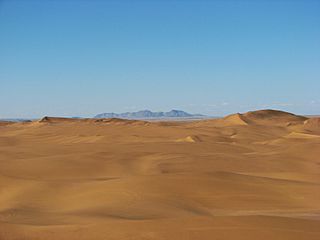
The Namib is a coastal desert in Southern Africa. The name Namib is of Khoekhoegowab origin and means "vast place". According to the broadest definition, the Namib stretches for more than 2,000 kilometres (1,200 mi) along the Atlantic coasts of Angola, Namibia, and South Africa, extending southward from the Carunjamba River in Angola, through Namibia and to the Olifants River in Western Cape, South Africa. The Namib's northernmost portion, which extends 450 kilometres (280 mi) from the Angola-Namibia border, is known as Moçâmedes Desert, while its southern portion approaches the neighboring Kalahari Desert. From the Atlantic coast eastward, the Namib gradually ascends in elevation, reaching up to 200 kilometres (120 mi) inland to the foot of the Great Escarpment. Annual precipitation ranges from 2 millimetres (0.079 in) in the aridest regions to 200 millimetres (7.9 in) at the escarpment, making the Namib the only true desert in southern Africa. Having endured arid or semi-arid conditions for roughly 55–80 million years, the Namib may be the oldest desert in the world and contains some of the world's driest regions, with only western South America's Atacama Desert to challenge it for age and aridity benchmarks.

The Namib-Naukluft Park is a national park in western Namibia, situated between the coast of the Atlantic Ocean and the edge of the Great Escarpment. It encompasses part of the Namib Desert, the Naukluft mountain range, and the lagoon at Sandwich Harbour. The best-known area of the park and one of the main visitor attractions in Namibia is Sossusvlei, a clay pan surrounded by dunes, and Sesriem, a small canyon of the Tsauchab. The desert research station of Gobabeb is situated within the park.

Benguela is a province of Angola, situated in the west of the country. It lies on the Atlantic Ocean, and borders the provinces of Cuanza Sul, Namibe, Huila, and Huambo. The province has an area of 39,826 square kilometres (15,377 sq mi) and its capital is Benguela. According to the 2014 census, there were 2,231,385 inhabitants in the province. The current governor of Benguela is Isaac dos Anjos.

Moçâmedes is a city in southwestern Angola, capital of Namibe Province. The city's current population is 255,000. Founded in 1840 by the Portuguese colonial administration, the city was named Namibe between 1985 and 2016. Moçâmedes has a cool dry climate and desert vegetation, because it is near the Namib Desert.

Namibe Province is a province of Angola. Under Portuguese rule it was the Moçâmedes District. It has an area of 57,091 km2 and had a 2014 census population of 495,326. The port and city of Moçâmedes is the capital of the province with a population of 250,000 in 2014. Iona National Park lies within the province.
Lagoa dos Patos is the largest lagoon in Brazil and the largest coastal lagoon in South America. It is located in the state of Rio Grande do Sul, southern Brazil. It covers an area of 10,100 km2 (3,900 sq mi), is 180 miles (290 km) long and has a maximum width of 44 miles (71 km).

Rodrigo de Freitas Lagoon is a lagoon in the district of Lagoa in the Zona Sul area of Rio de Janeiro. The lagoon is connected to the Atlantic Ocean, allowing sea water to enter by a canal along the edge of a park locally known as Jardim de Alah.
Iona National Park is the largest national park in Angola. It is situated in the Southwestern corner of the country, in Namibe Province. It is roughly bound by the Atlantic Ocean to the West, an escarpment to the East that marks the beginning of the interior plateau, the Curoca River to the North, and the Cunene River to the South. It is about 200 kilometres (120 mi) south of the city of Namibe and covers 5,850 square miles (15,200 km2) sq. miles.
Lagoon Mirim or Merín is a large estuarine lagoon which extends from southern Rio Grande do Sul state in Brazil into eastern Uruguay. Lagoa Mirim is separated from the Atlantic Ocean by a sandy, partially barren isthmus.

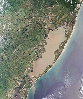
The Serra Geral is a mountain range in southern Brazil, constituting the southern portion of the Serra do Mar system which runs along Brazil's southeastern coast. The Serra Geral runs parallel to the Atlantic coast in Santa Catarina and northern Rio Grande do Sul states, separating a narrow coastal plain from an interior plateau. The coastal plain is characterized by short rivers and frequent lagoons and bays, and lies within the humid tropical Serra do Mar coastal forests ecoregion.

Tourism in Namibia is a major industry, contributing N$7.2 billion to the country's gross domestic product. Annually, over one million travelers visit Namibia, with roughly one in three coming from South Africa, then Germany and finally the United Kingdom, Italy and France. The country is among the prime destinations in Africa and is known for ecotourism which features Namibia's extensive wildlife.

The Protected Landscape of Lagoas de Bertiandos e São Pedro de Arcos is a protected landscape situated in the municipality of Ponte de Lima, in the district of Viana do Castelo in Portugal.

The tourism industry in Angola is based on the country's natural environment, including its rivers, waterfalls and coastline. Angola's tourism industry is relatively new, as much of the country was ravaged during the post-colonial civil war which ended in 2002. Unlike most countries in the region, which generally give US, EU, and many other citizens a visa on arrival or require no visa at all, Angola has complicated visa requirements. This procedure towards visitors places the country at a disadvantage in the competitive international tourism market.

Angola is located on the western Atlantic Coast of Southern Africa between Namibia and the Republic of the Congo. It also is bordered by the Democratic Republic of the Congo and Zambia to the east. The country consists of a sparsely watered and somewhat sterile coastal plain extending inland for a distance varying from 50 to 160 km. Slightly inland and parallel to the coast is a belt of hills and mountains and behind those a large plateau. The total land size is 1,246,700 km2 (481,400 sq mi). It has an Exclusive Economic Zone of 518,433 km2 (200,168 sq mi).
Namibe Partial Reserve is a protected area in Angola. It is located to the north of Iona National Park, and separated by a narrow strip of occupied land along the Curoca River. This reserve has IUCN Category IV status and was proclaimed in 1960 by the authorities of Portuguese Angola. It covers 4,450 square kilometres (1,720 sq mi). This park is planned to be included into the Iona - Skeleton Coast Transfrontier Conservation Area.
Dorob National Park is a protected area in Erongo, along the central Namibian coast, which is 1,600 kilometres (990 mi) in length. It was gazetted as a national park under the Nature Conservation Ordinance No.4 of 1975 on 1 December 2010, and with Namib-Naukluft Park covers an area of 107,540 square kilometres (41,520 sq mi).
Tigres Island is an island in Angola. It is situated in the Namibe Province.

Saint Martin of the Tigers, sometimes referred to simply as Village of Tigres Bay, is a ghost town in southern Angola, located on Tigres Island, currently separated from the Angolan mainland by the Tigres Strait. For legal purposes it is also a commune in the municipality of Tômbua, in the province of Namibe.
