Curwensville Dam

Last updated
Curwensville Dam
Official nameCurwensville Dam
Location Pike Township, near Curwensville, Pennsylvania
Coordinates 40°57′14″N78°31′34″W / 40.954°N 78.526°W / 40.954; -78.526 Coordinates: 40°57′14″N78°31′34″W / 40.954°N 78.526°W / 40.954; -78.526
Dam and spillways
Impounds West Branch Susquehanna River
Length2,850 feet (1,050 m)
Reservoir
Creates West Branch Susquehanna River

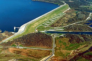
Curwensville Dam is located on the West Branch Susquehanna River about 0.6 miles (1 km) upstream from Curwensville in Clearfield County, Pennsylvania. The dam is an earth fill structure 2,850 feet long, rising 131 feet above the stream bed, with a spillway and gate-controlled outlet.

West Branch Susquehanna River river in Pennsylvania, United States

The West Branch Susquehanna River is one of the two principal branches, along with the North Branch, of the Susquehanna River in the northeastern United States. The North Branch, which rises in upstate New York, is generally regarded as the extension of the main branch, with the shorter West Branch being its principal tributary. The West Branch, which is 243 miles (391 km) long, is entirely within the state of Pennsylvania, draining a large mountainous area within the Allegheny Plateau in the western part of the state. Along most of its course it meanders along mountain ridges and through water gaps, forming a large zigzag arc through central Pennsylvania around the north end of the Allegheny Ridge. In colonial times the river provided an important water route to the Ohio River valley. In the 18th century, its lower valley became a significant industrial heartland of Pennsylvania. In the 20th century, the upper reaches of the West Branch turned a yellow/orange color due to sulfurous drainage from nearby and abandoned deep bituminous coal mines.

Clearfield County, Pennsylvania County in the United States

Clearfield County is a sixth-class county located in the U.S. state of Pennsylvania. As of the 2010 census, the population was 81,642. The county seat is Clearfield, and the largest city is DuBois. The county was created in 1804 and later organized in 1822.

Spillway structure for controlled release of flows from a dam or levee

A spillway is a structure used to provide the controlled release of flows from a dam or levee into a downstream area, typically the riverbed of the dammed river itself. In the United Kingdom, they may be known as overflow channels. Spillways ensure that the water does not overflow and damage or destroy the dam.

The reservoir, Curwensville Lake, has a storage capacity of 124,200 acre foot (153,000,000 m3) at spillway crest and extends 14 miles (23 km) upstream when filled to that level. The project controls a drainage area of 365 square miles (950 km2) or 98 percent of the West Branch at Curwensville and 75 percent at Clearfield, PA.

Reservoir A storage space for fluids

A reservoir is, most commonly, an enlarged natural or artificial lake, pond or impoundment created using a dam or lock to store water.

Curwensville Lake

Curwensville Lake is a reservoir located just to the south of the town of Curwensville, Pennsylvania. The lake was formed due to the construction of the Curwensville Dam to the north of the lake. Before the dam was built, there were several floods occurring along the West Branch Susquehanna River, affecting the towns of Curwensville, and Clearfield to the north. On September 3, 1954 a Flood Control Act was passed due to the flooding along the West Branch river basin. The dam cost $20,400,000 to construct.

The project is owned and operated by the United States Army Corps of Engineers. [1] Clearfield County operates and maintains the recreation area which includes a beach, boat launch, picnic areas, athletic fields, playgrounds, picnic pavilions and a 43-site campground.

United States Army Corps of Engineers federal agency under the Department of Defense and a major Army command

The United States Army Corps of Engineers (USACE) is a U.S. federal agency under the Department of Defense and a major Army command made up of some 37,000 civilian and military personnel, making it one of the world's largest public engineering, design, and construction management agencies. Although generally associated with dams, canals and flood protection in the United States, USACE is involved in a wide range of public works throughout the world. The Corps of Engineers provides outdoor recreation opportunities to the public, and provides 24% of U.S. hydropower capacity.

Related Research Articles

Table Rock Lake reservoir on Missouri-Arkansas border

Table Rock Lake is an artificial lake or reservoir in the Ozarks of southwestern Missouri and northwestern Arkansas. The lake is impounded by Table Rock Dam constructed from 1954 to 1958 on the White River by the U.S. Army Corps of Engineers.

Jennings Randolph Lake reservoir spanning the border between Maryland and West Virginia, United States

Jennings Randolph Lake is a reservoir of 952 acres (3.85 km2) located on the North Branch Potomac River in Garrett County, Maryland and Mineral County, West Virginia. It is approximately eight miles upstream of Bloomington, Maryland, and approximately five miles north of Elk Garden, West Virginia.

Guntersville Dam hydroelectric dam on the Tennessee River in Marshall County, in the U.S. state of Alabama

Guntersville Dam is a hydroelectric dam on the Tennessee River in Marshall County, in the U.S. state of Alabama. It is one of nine dams on the river owned and operated by the Tennessee Valley Authority, which built the dam in the late 1930s as part of a New Deal era initiative to create a continuous navigation channel on the entire length of the river and bring flood control and economic development to the region. The dam impounds the Guntersville Lake of 67,900 acres (27,500 ha), and its tailwaters feed into Wheeler Lake.

Burnsville Lake lake in United States of America

Burnsville Lake is both a recreational and flood control reservoir on Little Kanawha River located southeast of Burnsville in Braxton County, West Virginia. Burnsville Lake was authorized by the U.S. Congress in the Flood Control Act of 1938.

Saylorville Lake

Saylorville Lake is a reservoir on the Des Moines River in Iowa, United States. It is located 11 miles (18 km) upstream from the city of Des Moines, and 214 miles (344 km) from the mouth of the Des Moines River at the Mississippi River. It was constructed as part of a flood control system for the Des Moines River as well as to aid in controlling flood crests on the Mississippi, of which the Des Moines is a tributary. The lake and dam is owned and operated by the U.S. Army Corps of Engineers, Rock Island District.

Gavins Point Dam

Gavins Point Dam is a 1.9 mi (3 km) long embankment rolled-earth and chalk-fill dam which spans the Missouri River and impounds Lewis and Clark Lake. The dam joins Cedar County, Nebraska with Yankton County, South Dakota a distance of 811.1 river miles upstream of St. Louis, Missouri, where the river joins the Mississippi River. The dam and hydroelectric power plant were constructed as the Gavins Point Project from 1952 to 1957 by the United States Army Corps of Engineers as part of the Pick-Sloan Plan. The dam is located approximately 4 miles west or upstream of Yankton, South Dakota.

Lewis and Clark Lake

Lewis and Clark Lake is a 31,400 acre (130 km²) reservoir located on the border of the U.S. States of Nebraska and South Dakota on the Missouri River. The lake is approximately 25 miles (40 km) in length with over 90 miles (140 km) of shoreline and a maximum water depth of 45 feet (14 m). The lake is impounded by Gavins Point Dam and is managed by the U.S. Army Corps of Engineers, Omaha District.

Anderson Creek (Pennsylvania) river in the United States of America

Anderson Creek is a 23.6-mile-long (38.0 km) tributary of the West Branch Susquehanna River in Clearfield County, Pennsylvania, in the United States.

Summersville Lake

Summersville Lake is a reservoir located in the US state of West Virginia. The lake is formed by a rock-fill dam on the Gauley River, south of Summersville in Nicholas County. It is the largest lake in West Virginia, with 2,700 acres (1,100 ha) of water and over 60 miles (97 km) of shoreline at the summer pool water level. Its maximum depth is 327 feet.

Monticello Dam

Monticello Dam is a 304-foot (93 m) high concrete arch dam in Napa County, California, United States constructed between 1953 and 1957. The dam impounded Putah Creek to create Lake Berryessa in the Vaca Mountains.

Benbrook Lake reservoir on the Clear Fork of the Trinity River in Tarrant County, Texas

Benbrook Lake is a reservoir on the Clear Fork of the Trinity River in Tarrant County, Texas, USA. The lake is located approximately 10 miles (16 km) southwest of the center of Fort Worth, where the Clear Fork and the West Fork of the Trinity River join. The lake is impounded by the Benbrook Dam. The lake and dam are owned and operated by the U.S. Army Corps of Engineers, Fort Worth District.

Mansfield Hollow Lake lake of the United States of America

Mansfield Hollow Lake is a reservoir resting on the border of Windham County and Tolland County, Connecticut. The reservoir provides drinking water for Willimantic and helps control flooding in the 159-square-mile Thames River watershed. It was created by the Mansfield Hollow Dam and is entirely contained within Mansfield Hollow State Park and the Mansfield Hollow Wildlife Area. Designed and constructed by the United States Army Corps of Engineers, the dam substantially reduces flooding along the Quinebaug, Shetucket, and Thames rivers. Construction of the project began in 1949 with completion in 1952 at a cost of US$6.5 million. The Mansfield Hollow reservoir is located within the Shetucket River Watershed and is part of the Thames River Basin. Access to the site is available from US Route 6 and State Route 195. The damsite, covering an area of 25 acres (10 ha), was listed on the National Register of Historic Places in 2003.

Hop Brook Lake is spread over three communities in New Haven County, Connecticut, United States. These communities are Naugatuck, Middlebury, and Waterbury. A dam was created across Hop Brook in Naugatuck and the lake that was created is known as Hop Brook Lake.

Oologah Lake lake of the United States of America

Lake Oologah is a reservoir in northeastern Oklahoma. It is located near the towns of Oologah, Nowata, and Claremore. The lake has a surface of 29,500 acres (119 km2) of water and 209 miles (336 km) of shoreline with 11 lake-side parks. The water storage capacity is rated as 552,210 acre feet (681,140,000 m3). The lake is formed along the Verdigris River, and is a source of water for the Tulsa Metropolitan Area. The purpose of the dam and lake is flood control, water supply, navigation, recreation, and fish and wildlife.

Westville Dam

The Westville Dam is located on the Quinebaug River between Southbridge and Sturbridge, about 1.3 miles (2.1 km) west of the Southbridge town center and 18 miles (29 km) southwest of Worcester, Massachusetts.

Emigrant Lake (Oregon)

Emigrant Lake is a reservoir located 5 miles (8 km) southeast of Ashland, Oregon, at the southern end of the Rogue Valley. It has an elevation of 2,241 feet (683 m) above sea level. The lake has an average surface area of 806 acres (3.26 km2), and an average volume of 40,530 acre feet (49,990,000 m3). The lake is impounded by Emigrant Lake Dam, which stands 205 feet (62 m) above the surrounding farmland, and is located on Emigrant Creek at the west side of the lake. The spillway is located at the northern tip of the lake. Emigrant Creek is a tributary of Bear Creek.

Nottely Dam

Nottely Dam is a hydroelectric and flood storage dam on the Nottely River in Union County, in the U.S. state of Georgia. The dam is owned and operated by the Tennessee Valley Authority, which built the dam in the early 1940s as a flood control structure and to help regulate flow at nearby Hiwassee Dam. The dam impounds the Lake Nottely of 4,180 acres (16.9 km2). While the dam was built primarily for flood storage, a generator was installed at Nottely in the 1950s, giving it a small hydroelectric output.

John Redmond Reservoir

John Redmond Reservoir is a reservoir on the Neosho River in eastern Kansas. Built and managed by the U.S. Army Corps of Engineers, it is used for flood control, recreation, water supply, and wildlife management. It borders the Flint Hills National Wildlife Refuge to the northwest.

Lake Hudson (Oklahoma)

Lake Hudson, also known as Markham Ferry Reservoir, is a man-made reservoir in Mayes County, Oklahoma, United States, about 2 miles (3.2 km) northwest of Locust Grove, Oklahoma and 8 miles (13 km) southeast of Pryor, Oklahoma. It was created by the completion of the Robert S. Kerr Dam on the Grand River in 1964. It is managed by the Grand River Dam Authority (GRDA).

Brantley Dam

Brantley Dam is a flood control and irrigation water storage dam on the Pecos River in Eddy County, New Mexico about 13 miles (21 km) north of Carlsbad, New Mexico and 10 miles (16 km) upstream from Avalon Dam.

References