With a population of over 123 million in 2017, Mexico ranks as the 11th most populated country in the world. It is the most populous Spanish-speaking country and the third-most populous in the Americas after United States and Brazil. Throughout most of the twentieth century Mexico's population was characterized by rapid growth. Although this tendency has been reversed and average annual population growth over the last five years was less than 1%, the demographic transition is still in progress, and Mexico still has a large cohort of youths. The most populous city in the country is the capital, Mexico City, with a population of 8.9 million (2016), and its metropolitan area is also the most populated with 20.1 million (2010). Approximately 50% of the population lives in one of the 55 large metropolitan areas in the country. In total, about 78.84% of the population of the country lives in urban areas, meaning that only 21.16% live in rural areas.

Taos is a town in Taos County in the north-central region of New Mexico in the Sangre de Cristo Mountains, incorporated in 1934. As of the 2010 census, its population was 5,716. Other nearby communities include Ranchos de Taos, Cañon, Taos Canyon, Ranchitos, El Prado, and Arroyo Seco. The town is close to Taos Pueblo, the Native American village and tribe from which it takes its name.

Hidalgo County is the southernmost county of the U.S. state of New Mexico. As of the 2010 census, the population was 4,894. The county seat and largest city is Lordsburg. A bill creating Hidalgo from the southern part of Grant County was passed on February 25, 1919, taking effect at the beginning of 1920. The county was named for the town north of Mexico City where the Treaty of Guadalupe Hidalgo was signed, which in turn was named for Miguel Hidalgo y Costilla, the priest who is known as the "Father of Mexican Independence". This county abuts the Mexican border.

Catron County is a county in the U.S. state of New Mexico. As of the 2010 census, the population was 3,725, making it New Mexico's third-least populous county. Its county seat is Reserve. Catron County is New Mexico's largest county by area.
Mesilla is a town in Doña Ana County, New Mexico, United States. The population was 2,196 at the 2010 census. It is part of the Las Cruces Metropolitan Statistical Area.

Bernalillo is a town in Sandoval County, New Mexico, in the United States. As of the 2010 census, the town population was 8,320. It is the county seat of Sandoval County.

Mexicans are the people of the United Mexican States, a multiethnic country in North America. Mexicans can also be those who identify with the Mexican cultural or national identity.

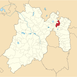
La Paz is a municipality in the State of Mexico, Mexico, with its seat at the town of Los Reyes Acaquilpan. It is located on the dividing line between Mexico State and the eastern edge of the Federal District and is part of the Greater Mexico City area. The area was part of a region called "Atlicpac" which in Náhuatl means 'above or at the edge of water.' The current city's/municipality's glyph symbolizes water.
Mexico, officially the United Mexican States, is a country in the southern portion of North America. It is bordered to the north by the United States; to the south and west by the Pacific Ocean; to the southeast by Guatemala, Belize, and the Caribbean Sea; and to the east by the Gulf of Mexico. Covering almost 2,000,000 square kilometres (770,000 sq mi), the nation is the fifth largest country in the Americas by total area and the 13th largest independent state in the world. With an estimated population of over 120 million people, the country is the eleventh most populous state and the most populous Spanish-speaking state in the world, while being the second most populous nation in Latin America after Brazil. Mexico is a federation comprising 31 states and Mexico City, a special federal entity that is also the capital city and its most populous city. Other metropolises in the state include Guadalajara, Monterrey, Puebla, Toluca, Tijuana and León.

Ocosingo is a city and its surrounding municipality (municipio) of the same name in the Mexican state of Chiapas.
El Salto is a town and seat of the municipality of Pueblo Nuevo in the southwestern part of the Mexican state of Durango. It is by far the largest town on Federal Highway 40 between the city of Durango and Mazatlán, Sinaloa. As of 2010, the town had a total population of 24,241,
Buenavista is the largest town in Tultitlán Municipality in State of Mexico, Mexico. The town is part of the Mexico City metropolitan area and had a 2010 census population of 206,081 inhabitants, or 39.32% of its municipal population of 524,074. The town lies near the northern tip of the Federal District. It is the second-largest locality in Mexico that is not a municipal seat. Tultitlán Municipality's seat lies in the town of Tultitlán de Mariano Escobedo, with a population of 31,936.
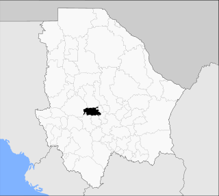
The Tenth Federal Electoral District of Chihuahua(X Distrito Electoral Federal de Chihuahua) is a defunct Federal Electoral District of the Mexican state of Chihuahua. It was in existence from 1979 to 1997 and returned one deputy to the Chamber of Deputies for each of the 51st to 56th Congresses.

Ocoyoacac is a town and municipality in the State of Mexico in Mexico. The municipality covers an area of 134.71 km². It is one of the 17 municipalities that border Mexico City. It borders the Distrito Federal's western borough of Cuajimalpa.
Tecámac is a municipality in State of Mexico in Mexico. The municipality covers an area of 157.34 km². The municipal seat lies in the town (locality) of Tecámac de Felipe Villanueva. Its largest town, Ojo de Agua, with a population of 242,283 inhabitants, is the largest locality in Mexico that is not a municipal seat.

Isla Mujeres is one of the ten municipalities of the Mexican state of Quintana Roo, on the Yucatán Peninsula. Most of the municipality is located on the mainland in the northeastern corner of the state. Its municipal seat, also called Isla Mujeres, is a small town situated on the island from which it takes its name, about 13 kilometres (8.1 mi) northeast of Cancún in the Caribbean Sea. It is the easternmost municipal seat in Mexico. In the 2010 census, the town had a population of 16,203 inhabitants.

Tome is an unincorporated village and census-designated place in Valencia County, New Mexico, United States. It is located in the Rio Grande valley near the foot of Tome Hill, a notable Catholic pilgrimage site. The village lies along New Mexico State Road 47 and is neighbored by Valencia to the north and Adelino to the south. It is the location of the Valencia Campus of the University of New Mexico. Tome has a post office with ZIP code 87060. The population was 1,867 as of the 2010 census.

Ecatepec, (Spanish[ekateˈpek] once officially Ecatepec de Morelos, is a city and municipality in the State of Mexico. Both are usually known simply as "Ecatepec". The city is practically co-extensive with the municipality, with the city's 2005 population of 1,687,549 being 99.9% of the total municipal population of 1,688,258. The provisional population at the 2010 Census was 1,658,806. The city forms the most populous suburb of Mexico City and the fifteenth suburb in the world in population. It is also Mexico's most populous municipality after Iztapalapa, Mexico City.
Villa Madero is a town in the Madero Municipality, in the State of Michoacán, Mexico. Established in 1868 with the name of Cruz De Caminos. According to tradition the first inhabitant of the place was a man named Armas, he is now considered the town's founder. The land where the town currently sits belonged to La Hacienda De La Concepcion. The village is the point of intersection of the paths that lead to Acuitzio, Etucuaro, Curuchancio and Tacambaro, this is why it became known as Cruz De Caminos.