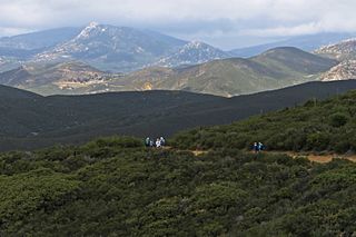
Cuyamaca is a region of eastern San Diego County. It lies east of the Capitan Grande Indian Reservation in the western Laguna Mountains, north of Descanso and south of Julian. Named for the 1845 Rancho Cuyamaca Mexican land grant, the region is now dominated by the 26,000-acre (110 km2) Cuyamaca Rancho State Park. Within the park is the prominent Cuyamaca Peak, the second-highest mountain in San Diego County at 6,512 feet (1,984.9 m).

State Route 79 is a state highway in the U.S. state of California. The route begins at Interstate 8 (I-8) in San Diego County, continuing north through the town of Cuyamaca into Julian. After passing through Warner Springs, the route crosses into Riverside County, serving the cities of Temecula and Murrieta. SR 79 ends at I-10 in Beaumont.

Campo is an unincorporated community in the Mountain Empire area of southeastern San Diego County, California, United States. The population was 2,684 at the 2010 census. For statistical purposes, the United States Census Bureau has defined Campo as a census-designated place (CDP). The census definition of the area may not precisely correspond to local understanding of the area with the same name.

Penn State Lehigh Valley is a commonwealth campus of Pennsylvania State University located in Center Valley, outside of Allentown in the Lehigh Valley region of Pennsylvania. Founded in 1912, Penn State Lehigh Valley is the oldest of Penn State's commonwealth campuses.
Grossmont College is a public community college in El Cajon, California. Its name originated with the silent film actor and producer William J. Gross, who was enticed by Ed Fletcher to invest the purchase of land, part of which was called Grossmont. The campus sits in the Fletcher Hills community of El Cajon and is bordered by the cities of San Diego and Santee. Grossmont College along with Cuyamaca College make up what is the Grossmont-Cuyamaca Community College District. Grossmont is part of the California Community College System.

The Sweetwater River is a 55-mile (89 km) long stream in San Diego County, California.

Cuyamaca College is a public community college in Rancho San Diego, California. It is part of the Grossmont-Cuyamaca Community College District and the California Community Colleges System. Along with Grossmont College, it serves the eastern suburbs in the San Diego area. Cuyamaca College opened in 1978 and now offers 81 associate's degree programs and 66 training certification programs to approximately 8,500 students. Many of the college's students transfer to the University of California, San Diego or San Diego State University to complete their bachelor's degrees. Cuyamaca's mascot is the coyote.

Descanso is a small unincorporated community in the Cuyamaca Mountains, within the Mountain Empire area of southeastern San Diego County, California. The community's name is a Spanish word meaning "rest from labor".
The Cuyamaca Mountains, locally the Cuyamacas, are a mountain range of the Peninsular Ranges System, in San Diego County, southern California. The mountain range runs roughly northwest to southeast. The Laguna Mountains are directly adjacent to the east, with Palomar Mountain and Hot Springs Mountain more distant to the north.

The Grossmont–Cuyamaca Community College District is a California community college district comprising two colleges, Grossmont College and Cuyamaca College that serve about 28,000 students a year. Grossmont College is located in El Cajon, California and Cuyamaca College is located in Rancho San Diego, California, and primarily serves East San Diego and East County communities.
Rancho Cuyamaca was a 35,501-acre (143.67 km2) Mexican land grant in the Cuyamaca Mountains and Laguna Mountains, in present-day San Diego County, California, United States.

The Viejas Group of Capitan Grande Band of Mission Indians of the Viejas Reservation, also called the Viejas Band of Kumeyaay Indians, is a federally recognized tribe of Kumeyaay Indians.

The Capitan Grande Reservation is a Kumeyaay Indian reservation in San Diego County, California, jointly controlled by the Barona Group of Capitan Grande Band of Mission Indians and Viejas Group of Capitan Grande Band of Mission Indians. The reservation is uninhabited and is 15,753 acres (63.75 km2) large, located in the Cuyamaca Mountains and middle of the Cleveland National Forest and west of Cuyamaca Peak. The closest town is Alpine, California.
San Vicente Creek is a 22.2-mile-long (35.7 km) stream in San Diego County, California.

East County is a region of San Diego County, California, east of San Diego.

The Mountain Empire is a rural area in southeastern San Diego County, California. The Mountain Empire subregion consists of the backcountry communities in southeastern San Diego County. The area is also sometimes considered part of the East County region of San Diego County.
Coleman Creek in San Diego County, California is a tributary of the San Diego River that arises at the top of the valley running southeasterly from Julian, at a saddle between two ridges of the Cuyamaca Mountains just south of Kentwood-In-The-Pines. From there, Coleman Creek descends northwesterly down the valley to Julian, where it turns west, descending its canyon northwesterly through the site of Branson City, past the mouth of its tributary Eastwood Creek on the north, passing through the south end of Spencer Valley, past the mouth of its tributary Baily Creek on the north, then descending northwest down Quanai Canyon to its confluence with the San Diego River.
Eastwood Creek in San Diego County, California, is a tributary of Coleman Creek that arises in the Cuyamaca Mountains, at the north face of the gold bearing mountain north of Julian. From the source Eastwood Creek descends northwesterly a short distance, then turns southwest down a canyon to its confluence with Coleman Creek, just below the site of Branson City.
The Carrizo Creek and Carrizo Wash in California are a stream and an arroyo that the stream flows into, in San Diego County, California and Imperial County, California.
Foster was a settlement in east San Diego County, California. It was located approximately 3.5 miles (5.6 km) north of Lakeside, near the present-day location of the San Vicente Dam. It was the terminus of the San Diego, Cuyamaca, and Eastern Railroad from 1889, when the railroad reached the town, until 1916, when parts of the railway between Lakeside and Foster were damaged by floods. The line was never rebuilt and the town declined thereafter. There were 7 buildings in Foster in 1891–93, according to the 1893 USGS survey map. A road connecting Lakeside to Ramona and Julian ran through Foster until 1942, when the section just north of Foster was submerged to create San Vicente Reservoir and the road was rerouted further west, bypassing the settlement. The town was named after local rancher Joseph Foster.


