
Transportation planning is the process of defining future policies, goals, investments, and spatial planning designs to prepare for future needs to move people and goods to destinations. As practiced today, it is a collaborative process that incorporates the input of many stakeholders including various government agencies, the public and private businesses. Transportation planners apply a multi-modal and/or comprehensive approach to analyzing the wide range of alternatives and impacts on the transportation system to influence beneficial outcomes.

Sustrans is a United Kingdom walking, wheeling and cycling charity, and the custodian of the National Cycle Network.

OpenStreetMap (OSM) is a collaborative project to create a free editable geographic database of the world. The geodata underlying the maps is considered the primary output of the project. The creation and growth of OSM has been motivated by restrictions on use or availability of map data across much of the world, and the advent of inexpensive portable satellite navigation devices.

The Transport Direct Programme was a division of the UK Department for Transport (DfT) to develop standards, data and better information technology systems to support public transport. It developed and operates the Transport Direct Portal which is a public facing multi-modal journey planner. It also supports the creation and management of comprehensive databases of all public transport movements in the United Kingdom with Traveline. During 2010 two key datasets were released as Open Data and published on www.data.gov.uk.
Crossrail Glasgow is a proposed railway development in Central Scotland to connect the stations Glasgow Central and Queen Street. It has been estimated at a cost of £200 million.

London has an extensive and developed transport network which includes both private and public services. Journeys made by public transport systems account for 37% of London's journeys while private services accounted for 36% of journeys, walking 24% and cycling 2%. London's public transport network serves as the central hub for the United Kingdom in rail, air and road transport.

The Cambridgeshire Guided Busway, known locally as The Busway, connects Cambridge, Huntingdon and St Ives in the English county of Cambridgeshire. It is the longest guided busway in the world, overtaking the O-Bahn Busway in Adelaide, South Australia.
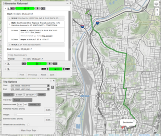
A journey planner, trip planner, or route planner is a specialized search engine used to find an optimal means of travelling between two or more given locations, sometimes using more than one transport mode. Searches may be optimized on different criteria, for example fastest, shortest, fewest changes, cheapest. They may be constrained, for example, to leave or arrive at a certain time, to avoid certain waypoints, etc. A single journey may use a sequence of several modes of transport, meaning the system may know about public transport services as well as transport networks for private transportation. Trip planning or journey planning is sometimes distinguished from route planning, which is typically thought of as using private modes of transportation such as cycling, driving, or walking, normally using a single mode at a time. Trip or journey planning, in contrast, would make use of at least one public transport mode which operates according to published schedules; given that public transport services only depart at specific times, an algorithm must therefore not only find a path to a destination, but seek to optimize it so as to minimize the waiting time incurred for each leg. In European Standards such as Transmodel, trip planning is used specifically to describe the planning of a route for a passenger, to avoid confusion with the completely separate process of planning the operational journeys to be made by public transport vehicles on which such trips are made.
The Transport Direct Portal was a distributed Internet-based multi-modal journey planner providing information for travel in England, Wales and Scotland. It was managed by Transport Direct, a division of the Department for Transport. It was launched in 2004 and was operated by a consortium led by Atos and later enhanced to include a cycle journey planning function. The closure of the portal was announced in September 2014 "Closure of the Transport Direct website"(PDF). Archived from the original(PDF) on 12 September 2014. and the portal closed on 30 September 2014.

Cycling in London is a popular mode of transport and leisure activity within the capital city of the United Kingdom. Following a national decline in the 1960s of levels of utility cycling, cycling as a mode of everyday transport within London began a slow regrowth in the 1970s. This continued until the beginning of the 21st century, when levels began to increase significantly - during the period from 2000 to 2012, the number of daily journeys made by bicycle in Greater London doubled to 580,000. The growth in cycling can partly be attributed to the launch in 2010 by Transport for London (TfL) of a cycle hire system throughout the city's centre. By 2013, the scheme was attracting a monthly ridership of approximately 500,000, peaking at a million rides in July of that year. Health impact analyses have shown that London would benefit more from increased cycling and cycling infrastructure than other European cities.
CycleNetXChange provides a standard format with which to exchange cycle path data, together with information about the quality of routes; This enables computerised transport systems to provide cycle routes.

A site plan or a plot plan is a type of drawing used by architects, landscape architects, urban planners, and engineers which shows existing and proposed conditions for a given area, typically a parcel of land which is to be modified. Sites plan typically show buildings, roads, sidewalks and paths/trails, parking, drainage facilities, sanitary sewer lines, water lines, lighting, and landscaping and garden elements.

The New Zealand Cycle Trail project is a New Zealand government initiative, co-funded together with local councils and charitable trusts, which is to build and operate a network of cycle routes through the country.
Cambridge is a university town and the administrative centre of the county of Cambridgeshire, England. It lies in East Anglia about 50 miles (80 km) north of London. Its main transport links are the M11 road to London, the A14 east–west road and the West Anglia Main Line railway line to London.

Traveline is a public transport route planner service provided by a partnership between local authorities and transport operators in the UK to provide impartial and comprehensive information about public transport which has operated since 2000. It prepares comprehensive public transport data for the UK and provides a number of regional public transport journey planners.

The General Transit Feed Specification (GTFS) defines a common format for public transportation schedules and associated geographic information.
Cycling England was an independent body funded by the Department for Transport to promote cycling in England. It was founded in 2005 to replace the National Cycling Strategy Board. Following the 2010 Comprehensive Spending review it was earmarked for abolition, to be replaced by Local Sustainability Travel Funds and new ways of supporting cycling. Cycling England ceased to exist as a public body on 1 April 2011.
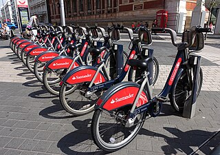
Santander Cycles is a public bicycle hire scheme in London in the United Kingdom. The scheme's bicycles are popularly known as Boris Bikes, after Boris Johnson who was Mayor of London when the scheme began operating.
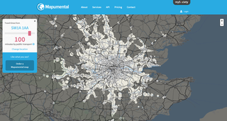
Mapumental was a web-based application for displaying journeys in terms of how long they take, rather than by distance, a technique also known as isochrone or geospatial mapping. It was developed by British organisation mySociety but was withdrawn in 2020.

The Parramatta Light Rail is a project for a twelve-kilometre (seven-mile) light rail line in Sydney, New South Wales, Australia, which is currently under construction. The line will run from Westmead to Carlingford via the Western Sydney centre of Parramatta. The initial announcement of the project also included an eastern branch from Camellia to Strathfield. Plans to construct this branch were deferred in February 2017, and in October the original plans were replaced with a redesigned and truncated route to Sydney Olympic Park. The project will add to light rail in Sydney but the new line will be completely separated from the existing lines. It is being managed by Transport for NSW.