
Casa Conejo is an unincorporated county island in Newbury Park, Ventura County, California, United States. It was the first planned community in Newbury Park and began building in 1960. When the city of Thousand Oaks incorporated 4 years later, the new developments in Newbury Park were incorporated into the city boundaries before being subdivided. The community is bordered by Old Conejo Road and US 101 to the north, Borchard Road to the south, Jenny Drive to the west, and Sequoia Middle School to the east. For statistical purposes, the United States Census Bureau has defined Casa Conejo as a census-designated place (CDP). The census definition of the area may not precisely correspond to local understanding of the area with the same name. The population was 3,249 at the 2010 census, up from 3,180 at the 2000 census. Casa Conejo is located in a roughly rectangle-shaped unincorporated area surrounded by the city of Thousand Oaks.

Thousand Oaks is the second-largest city in Ventura County, California, United States. It is in the northwestern part of Greater Los Angeles, approximately 15 miles (24 km) from the city of Los Angeles and 40 miles (64 km) from Downtown. It is named after the many oak trees present in the area.

The Conejo Valley is a region spanning both southeastern Ventura County and northwestern Los Angeles County in Southern California, United States. It is located in the northwestern part of the Greater Los Angeles Area.
Newbury Park is a populated place and town in Ventura County, California, United States. Most of it lies within the western Thousand Oaks city limits, while unincorporated areas include Casa Conejo and Ventu Park. About 28,000 residents of Thousand Oaks reside in Newbury Park.

The Stagecoach Inn Museum in Newbury Park, California, originally known as the Grand Union Hotel, was used as a resting area for people who traveled from Los Angeles to Santa Barbara. Besides a hotel and stagecoach stop, it has also been used as a post office, church, restaurant and military school. It is California Historical Landmark No. 659 and is listed in the National Register of Historic Places. It played a major role in the development of the stage line transportation network in California. The hotel was also the first business venture in the Conejo Valley.

Arroyo Conejo is the longest creek in the Conejo Valley, sprawling over the cities of Thousand Oaks and Camarillo, and the communities of Newbury Park, Casa Conejo and Santa Rosa Valley. Arroyo Conejo is the primary drainage for the City of Thousand Oaks. Its watershed covers 57 square miles (150 km2) of which 43 square miles (110 km2) are in the Conejo Valley and 14 square miles (36 km2) in the Santa Rosa Valley.

Hill Canyon is a deep canyon in the western Simi Hills and within northern Newbury Park and Thousand Oaks, in Ventura County, southern California.

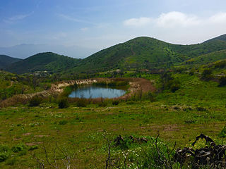
The Conejo Canyons Open Space consists of 1,628 acres (659 ha) of open-space areas in northernmost Newbury Park, Ventura County, California. It consists of deeply eroded canyons, numerous ridgelines and plateaus in the northwestern portion of the Conejo Valley. The area consists of diverse natural features such as deep canyons with perennial streams, prominent ridgelines, volcanic mountains, and a variety of natural habitats. While some of the flora includes chaparral, riparian habitats, oak woodlands and coastal sage, fauna includes mountain lions, coyotes, mule deer, and bobcats.

Knoll Open Space, also known as Knoll Park, is a 21 acres (8.5 ha) open-space area in western Newbury Park, California, United States, adjacent to Pepper Tree Playfield. The Knoll Open Space is owned and operated by the Conejo Open Space Conservation Agency (COSCA), and the flora here includes coastal sage scrub and grass. The 1.9 miles (3.1 km) Knoll Trail goes from its trailhead at North Reino Road and leads to the top of Rabbit Hill. The hill offers panoramic views of the Conejo Valley, Santa Monica Mountains, Conejo Mountain, and Boney Mountain.
The Potrero Ridge Open Space is a passive recreation area in the southwestern portion of Newbury Park, CA and the Conejo Valley that encompasses eastern parts of the Potrero Ridge. The open-space area contains a total of 203 acres (82 ha), and is owned and operated by the Conejo Open Space Conservation Agency (COSCA). It is adjacent to the Dos Vientos Open Space in the west, which provides further access to the Santa Monica Mountains National Recreation Area by Satwiwa, as well as the Alta Vista Open Space, Los Vientos Open Space, and Los Robles Trail which leads to Los Robles Open Space in Thousand Oaks, CA and further into Westlake Village.

Borchard Community Park is a public park located in western Newbury Park, CA. Situated adjacent to both the Newbury Park High School and the Borchard Maintenance Shop, the park is situated at the corner of Reino Road and Borchard Road at the foothills of the Santa Monica Mountains. The park encompasses 29 acres, which is home to various courts for recreational sports, fitness area, community rooms, a farm themed playground, picnic areas, several fields, and a skate park. The park was established by the Conejo Recreation & Park District (CRPD) in 1969. It has two volleyball courts, four tennis courts, two stages, three softball fields, a basketball court, barbecue grills, two bocci courts, a gymnasium, horseshoe pits, a kitchen, a soccer field, two playgrounds, and more.

Dos Vientos Community Park in southwestern Newbury Park, CA is the largest of Conejo Recreation & Park District’s public parks in the Conejo Valley. It is adjacent to the Dos Vientos Community Center, which offers a preschool, sports, and other activities. The park contains sand volleyball courts, baseball-, basketball- and tennis courts, soccer fields, playground areas, and picnic tables and barbecue grills. It is adjacent to the Dos Vientos Open Space through the Park View Trail, which is a 1,216 acre natural open-space, bordering an additional 16,000 acres of open space stretching over the Santa Monica Mountains National Recreation Area to the Pacific Ocean. The Park View Trail ends at Via Ricardo, directly across the road from the Powerline Trail and Dos Vientos Open Space.

Conejo Mountain is a 1,814-foot-high mountain (553 m) in Ventura County, California near Camarillo on the eastern boundary of the Oxnard Plain. At the western edge of the Conejo Valley, it is adjacent to the Santa Monica Mountains. Crossing what was once a formidable barrier for travelers, U.S. Route 101 passes through the area on the steep Conejo Grade.

Pepper Tree Playfield is a 21.7-acre community park located in western Newbury Park, California. It is located at the corner of Reino and Old Conejo Roads, and was acquired by the Conejo Recreation & Park District (CRPD) in 1977, but not developed nor opened until 1983. It contains a 0.83-mile fitness trail loop, and is nearby numerous trailheads. The park is within walking distance from the Conejo Vista Trailhead in Old Conejo Open Space, located immediately north of Pepper Tree Playfield, and the park is directly across the street from the Knoll Trailhead in Knoll Open Space, which is to the park’s immediate east, crossing North Reino Road. It is also an access point for trails leading to the Conejo Mountain. Pepper Tree Playfield is named for its many pepper trees, which surrounds the park area.
Dos Vientos Open Space is a 1,216 acres (492 ha) open space area in western Newbury Park, California. It contains more than 41 miles (66 km) of trails used for cycling, hiking and equestrians. Originally a part of the Rancho Guadalasca Spanish Land Grant of 1836, the area is now an important wildlife movement corridor into the Santa Monica Mountains through the Point Mugu State Park. It provides a habitat for a variety of wildlife, including bobcats, mule deer, coyotes, eagles, hawks, barn owls, mountain lions, and more. It provides regional and internal trail connections, many trails offering panoramic views of the Conejo Valley, Oxnard Plain, Topatopa Mountains, Channel Islands, and the Pacific Ocean. Some of the endangered plant species found here include Conejo buckwheat, Verity's liveforever, and Conejo dudleya. The landscape is undeveloped, and dominated by coastal sage scrub, grassy hillsides, oak woodlands, and chaparral habitats.
Dos Vientos is a neighborhood in westernmost Newbury Park, California, which borders Dos Vientos Open Space and the Santa Monica Mountains. It was a 2,350-unit housing development which was approved by the Thousand Oaks City Council in April 1988. It is an upscale and master-planned community. Major development found place after infrastructure was built to support the homes in 1998. It was the largest residential project ever within Newbury Park. It has a maximum elevation of 2,500 feet.

Conejo Recreation and Park District (CRPD) is the park management agency for most of the parks in the Conejo Valley, California. Established in 1962, CRPD later established Conejo Open Space Conservation Agency (COSCA) in 1977 through a joint effort with the City of Thousand Oaks. COSCA administers over 15,000 acres of open space and 140 miles of trails, while CRPD administers over 50 community parks. In 2019, CRPD's annual operating budget was $20 million, of which about 70% comes from property taxes.

Timber School was the first school in Newbury Park, California when established in 1889. and the current 1924 reconstructed Timber School is the oldest remaining school in the City of Thousand Oaks. It is also the oldest remaining public building in the Conejo Valley.

Newbury Road is the main street in Newbury Park, California, and runs parallel to the U.S. Route 101. The road is named for the town’s founder, Egbert Starr Newbury. The historic Newbury Park Post Office has had several locations on Newbury Road, including at the Stagecoach Plaza, a shopping complex with a name that implies the stagecoach heritage of the area. Stagecoach Plaza houses 14 restaurants and shops, and it is adjacent to additional shops on both sides.

The Newbury Park Post Office was the first post office in the Conejo Valley, established on July 16, 1875, by the valley's first postmaster, Egbert Starr Newbury.

