The Conejo Valley is a region spanning both southeastern Ventura County and northwestern Los Angeles County in Southern California, United States. It is located in the northwestern part of the Greater Los Angeles Area.
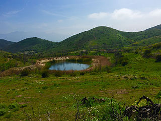
Dos Vientos Open Space is a 1,216 acres (492 ha) open space area in western Newbury Park, California. It contains more than 41 miles (66 km) of trails used for cycling, hiking and equestrians. Originally a part of the Rancho Guadalasca Spanish Land Grant of 1836, the area is now an important wildlife movement corridor into the Santa Monica Mountains through the Point Mugu State Park. It provides a habitat for a variety of wildlife, including bobcats, mule deer, coyotes, eagles, hawks, barn owls, mountain lions, and more. It provides regional and internal trail connections, many trails offering panoramic views of the Conejo Valley, Oxnard Plain, Topatopa Mountains, Channel Islands, and the Pacific Ocean. Some of the endangered plant species found here include Conejo Buckwheat, Verity's liveforever, and Conejo Dudleya. The landscape is undeveloped, and dominated by coastal sage scrub, grassy hillsides, oak woodlands, and chaparral habitats.
The Santa Monica Mountains National Recreation Area is a United States National Recreation Area containing many individual parks and open space preserves, located primarily in the Santa Monica Mountains of Southern California. The SMMNRA is located within the greater Los Angeles region, with two thirds of the parklands in northwest Los Angeles County, and the remaining third, including a Simi Hills extension, in southeastern Ventura County.
Arroyo Conejo is the longest creek in the Conejo Valley, sprawling over the cities of Newbury Park, Thousand Oaks, Camarillo, and the CDP’s Casa Conejo and Santa Rosa Valley. Arroyo Conejo is the primary drainage for the City of Thousand Oaks Its watershed covers 57 square miles (150 km2) of which 43 square miles (110 km2) are in the Conejo Valley and 14 square miles (36 km2) in the Santa Rosa Valley.
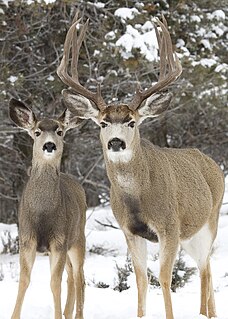
The mule deer is a deer indigenous to western North America; it is named for its ears, which are large like those of the mule. The several subspecies include the black-tailed deer.
The western pond turtle, also known commonly as the Pacific pond turtle is a species of small to medium-sized turtle in the family Emydidae. The species is endemic to the western coast of the United States and Mexico, ranging from western Washington state to northern Baja California. It was formerly found in Canada, but in May 2002, the Canadian Species at Risk Act listed the Pacific pond turtle as being extirpated.
“Potrero” means a farm for rearing horses or pasture ground in Spanish.[9]
↑ Murphy, Kelly (2012). Local Multi-Use Trails. Kelly Murphy. Page 84-86. ISBN9781479165599.
↑ Brundige, Donald G. and Sharron (1994). Bicycle Rides: Santa Barbara and Ventura Counties. Bd Enterprises. Page 253. ISBN9780961915162.
This page is based on this Wikipedia article Text is available under the CC BY-SA 4.0 license; additional terms may apply. Images, videos and audio are available under their respective licenses.
Related Research Articles
Newbury Park is a town located mostly within the western Thousand Oaks city limits in Ventura County, California, United States. It makes up all of ZIP code 91320, and is within area code 805. Lying within the Conejo Valley in the northwestern part of the Greater Los Angeles Area, Newbury Park abuts the Santa Monica Mountains. It is approximately 35 miles (56 km) from Downtown Los Angeles and less than 7 mi (11 km) from the Los Angeles County border in Westlake Village. The closest coastal city is Malibu, 22 mi (35 km) from Newbury Park, which may be reached through winding roads or hiking trails crossing the Santa Monica Mountains. About 28,000 of Thousand Oaks' 110,000 residents reside in Newbury Park. Newbury Park makes up around 40 percent of Thousand Oaks' total land area.
The Simi Hills are a low rocky mountain range of the Transverse Ranges in eastern Ventura County and western Los Angeles County, of southern California, United States.
Boney Mountain in Ventura County, California is one of the highest peaks in the Santa Monica Mountains. The prominent mountain visible from Newbury Park, California is 2,825 feet (861 m).. It is also known as Boney Peak. The mountain contains four of the highest peaks in the coastal range of the Santa Monica Mountains: Boney Peak, Sandstone Peak, Exchange Peak, and Tri Peaks. The highest summit in the Santa Monica Mountains is Sandstone Peak, situated less than a mile northeast of Boney Peak along the same ridge of volcanic rock. It is the top section of a mass of volcanic rock which solidified around 15 million years ago, and was later uplifted to its dominant position, overshadowing western Conejo Valley. The Chumash Native Americans have a long and deeply spiritual history of interaction at and near the mountain, and the peak is considered a sacred mountain to the Chumash people.
Santa Rosa Valley is a rural unincorporated community, named after the eponymous valley in which it lies, located in Ventura County, California, United States. For statistical purposes, the United States Census Bureau has defined Santa Rosa Valley as a census-designated place (CDP). The census definition of the area may not precisely correspond to local understanding of the area with the same name. The 2010 United States census reported Santa Rosa Valley's population was 3,334. Santa Rosa Valley sits at an elevation of 433 feet (132 m).
Rancho Conejo Playfields is a 13 acres (5.3 ha) multi-use community park in Newbury Park, California, adjacent to Conejo Canyons Open Space and the Arroyo Conejo Nature Preserve which includes 302 acres (122 ha) of public open-space land and numerous trails in the western Simi Hills.
Lynn Oaks Park is a seven-acre community park in the southern part of Newbury Park, CA, which includes trails to numerous surrounding nature areas, including but not limited to the Hope Nature Preserve, Hidden Valley, and the Santa Monica Mountains National Recreation Area. It was first developed as a community park in 1983 and is named for its many oak trees. The park contains a volleyball court, outdoor basketball court, soccer field, a playground, barbecue grills, water fountains and numerous picnic tables. Some of the trails include the shorter Spring Canyon Trail and Oak Creek Canyon Loop, while the Los Robles Trail connects Lynn Oaks Park to the Hope Nature Preserve and beyond to Hidden Valley and the Santa Monica Mountains National Recreation Area.
Satwiwa was a former Chumash village in the Santa Monica Mountains of Newbury Park, California. The current Satwiwa Native American Indian Culture Center is operated by the National Park Service in cooperation with the Friends of Satwiwa. Satwiwa has been inhabited by Chumash Indians for over 10,000 years. It is situated at the foothills of Boney Mountain, a sacred mountain for the Chumash.
Hill Canyon is a deep canyon in the western Simi Hills and within northern Newbury Park and Thousand Oaks, in Ventura County, southern California.
The Conejo Canyons Open Space consists of 1,628 acres (659 ha) of open-space areas in northernmost Newbury Park, Ventura County, California. It consists of deeply eroded canyons, numerous ridgelines and plateaus in the northwestern portion of the Conejo Valley. The area consists of diverse natural features such as deep canyons with perennial streams, prominent ridgelines, volcanic mountains, and a variety of natural habitats. While some of the flora includes chaparral, riparian habitats, oak woodlands and coastal sage, fauna includes mountain lions, coyotes, mule deer, and bobcats.
Cypress Park is a five-acre neighborhood park in southwestern Newbury Park, California. Acquired in 1969, the land was eventually developed into a community park in 1973. It contains a baseball field, a playground, picnic tables, and bleachers. It is owned and operated by the Conejo Recreation & Park District (CRPD). Situated immediately south of Cypress Elementary School, the park is also home to several ponds and smaller creeks. It is used for bird-observations, recreational activities, picnicking, and camping.
Deer Ridge Open Space is a 188-acre public-owned open-space area in the southwest portion of the town of Newbury Park, California. It contains a series of north-facing mountainous ridges and canyons, dominated by chaparral and oak trees. It shares borders with the Santa Monica Mountains National Recreation Area to the south, and the Los Robles Trail traverses the length of Deer Ridge Open Space. Its main trailhead is located on Potrero Road, while a smaller access point is located at the southern end of Felton Street. The Los Robles Trail is the Conejo Open Space Conservation Agency’s longest trail, and connects to open-space areas and parks such as the Los Padres Open Space, Conejo Ridge Open Space, Hope Nature Preserve, Old Conejo Open Space, and the Los Vientos Open Space. The trail in Newbury Park provides panoramic views of the Conejo Valley and Santa Monica Mountains, before entering the Hope Nature Preserve. The Los Robles Trail provides more than 25 miles of contiguous trails connecting Newbury Park to Westlake Village in Los Angeles County. Immediately south of the Deer Ridge Open Space in Newbury Park are the Hidden Valley and Rancho Sierra Vista Satwiwa.
Dos Vientos Community Park in southwestern Newbury Park, CA is the largest of Conejo Recreation & Park District’s public parks in the Conejo Valley. It is adjacent to the Dos Vientos Community Center, which offers a preschool, sports, and other activities. The park contains sand volleyball courts, baseball-, basketball- and tennis courts, soccer fields, playground areas, and picnic tables and barbecue grills. It is adjacent to the Dos Vientos Open Space through the Park View Trail, which is a 1,216 acre natural open-space, bordering an additional 16,000 acres of open space stretching over the Santa Monica Mountains National Recreation Area to the Pacific Ocean. The Park View Trail ends at Via Ricardo, directly across the road from the Powerline Trail and Dos Vientos Open Space.
Conejo Mountain is a 1,814-foot-high mountain (553 m) in Ventura County, California near Camarillo on the eastern boundary of the Oxnard Plain. At the western edge of the Conejo Valley, it is adjacent to the Santa Monica Mountains. Crossing what was once a formidable barrier for travelers, U.S. Route 101 passes through the area on the steep Conejo Grade.
Alta Vista Open Space is a 43-acre open-space area in western Newbury Park, California, United States, adjacent to Dos Vientos Open Space and its 1,216 acres of natural open space area and numerous trails. Its primary trail is the Ring Finger Trail, which is reached from its trailhead at the southern side of Calle Alta Vis, directly across the street from Calle Las Collinas. Most of the open-space area is owned by the homeowners association, while eleven acres are owned by the Conejo Open Space Conservation Agency (COSCA). Its flora contain large areas covered with chaparral and coastal sage scrub, while some endangered endemic species include Conejo Buckwheat, Verity's Dudleya, and Conejo Dudleya. It functions as a crucial wildlife corridor into the Santa Monica Mountains National Recreation Area through Point Mugu State Park. Some of the fauna here includes Mountain lions, coyotes, mule deer, bobcats, and more.
Ventu Park Open Space is a 141-acre open space area in Newbury Park, California. Its primary features are the Rosewood Trail leading to Angel Vista, a 1,603 ft peak in the Santa Monica Mountains. Parking for the Rosewood Trail is located at the Stagecoach Inn Park, across Lynn Road from the primary trailhead. The Rosewood Trail begins with oak woodland and crosses a creek at the canyon floor, before climbing up towards the steep Angel Vista Point. There are 360-degree panoramic views of the Conejo Valley, the Oxnard Plain, the California Channel Islands, Pacific Ocean, Point Mugu, Hidden Valley, as well as the Santa Monica-, Santa Susana- and Topa Topa Mountains.
Conejo Recreation and Park District (CRPD) is the park management agency for most of the parks in the Conejo Valley, California. Established in 1962, CRPD later established Conejo Open Space Conservation Agency (COSCA) in 1977 through a joint effort with the City of Thousand Oaks. COSCA administers over 15,000 acres of open space and 140 miles of trails, while CRPD administers over 50 community parks. CRPD's annual operating budget is $20,000,000, of which about 70% are from property taxes.