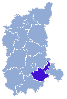
Bielice is a village in the administrative district of Gmina Kożuchów, within Nowa Sól County, Lubusz Voivodeship, in western Poland. It lies approximately 7 kilometres (4 mi) south-east of Kożuchów, 10 km (6 mi) south of Nowa Sól, and 28 km (17 mi) south-east of Zielona Góra.
Broniszów is a village in the administrative district of Gmina Kożuchów, within Nowa Sól County, Lubusz Voivodeship, in western Poland. It lies approximately 9 kilometres (6 mi) north-west of Kożuchów, 17 km (11 mi) west of Nowa Sól, and 18 km (11 mi) south of Zielona Góra.
Bulin is a village in the administrative district of Gmina Kożuchów, within Nowa Sól County, Lubusz Voivodeship, in western Poland. It lies approximately 5 kilometres (3 mi) west of Kożuchów, 15 km (9 mi) south-west of Nowa Sól, and 23 km (14 mi) south of Zielona Góra.

Cisów is a village in the administrative district of Gmina Kożuchów, within Nowa Sól County, Lubusz Voivodeship, in western Poland. It lies approximately 4 kilometres (2 mi) south of Kożuchów, 12 km (7 mi) south-west of Nowa Sól, and 26 km (16 mi) south of Zielona Góra.

Drwalewice is a village in the administrative district of Gmina Kożuchów, within Nowa Sól County, Lubusz Voivodeship, in western Poland. It lies approximately 5 kilometres (3 mi) east of Kożuchów, 9 km (6 mi) south-west of Nowa Sól, and 26 km (16 mi) south-east of Zielona Góra.
Dziadoszyce is a village in the administrative district of Gmina Kożuchów, within Nowa Sól County, Lubusz Voivodeship, in western Poland. It lies approximately 6 kilometres (4 mi) south-east of Kożuchów, 10 km (6 mi) south of Nowa Sól, and 28 km (17 mi) south-east of Zielona Góra.
Dziwiszowice is a village in the administrative district of Gmina Kożuchów, within Nowa Sól County, Lubusz Voivodeship, in western Poland. It lies approximately 6 kilometres (4 mi) south-east of Kożuchów, 9 km (6 mi) south of Nowa Sól, and 26 km (16 mi) south-east of Zielona Góra.

Książ Śląski is a village in the administrative district of Gmina Kożuchów, within Nowa Sól County, Lubusz Voivodeship, in western Poland. It lies approximately 9 kilometres (6 mi) north-west of Kożuchów, 12 km (7 mi) west of Nowa Sól, and 14 km (9 mi) south of Zielona Góra.
Mirocin Dolny is a village in the administrative district of Gmina Kożuchów, within Nowa Sól County, Lubusz Voivodeship, in western Poland. It lies approximately 6 kilometres (4 mi) north-west of Kożuchów, 13 km (8 mi) west of Nowa Sól, and 18 km (11 mi) south of Zielona Góra.

Mirocin Górny is a village in the administrative district of Gmina Kożuchów, within Nowa Sól County, Lubusz Voivodeship, in western Poland. It was known by its former name Herzogswaldau while in the Kingdom of Prussia. It lies approximately 7 kilometres (4 mi) west of Kożuchów, 16 km (10 mi) west of Nowa Sól, and 22 km (14 mi) south of Zielona Góra. The village has a population of 633.

Mirocin Średni is a village in the administrative district of Gmina Kożuchów, within Nowa Sól County, Lubusz Voivodeship, in western Poland. It lies approximately 5 kilometres (3 mi) west of Kożuchów, 14 km (9 mi) west of Nowa Sól, and 20 km (12 mi) south of Zielona Góra.
Podbrzezie Górne is a village in the administrative district of Gmina Kożuchów, within Nowa Sól County, Lubusz Voivodeship, in western Poland. It lies approximately 3 kilometres (2 mi) south-west of Kożuchów, 13 km (8 mi) south-west of Nowa Sól, and 24 km (15 mi) south of Zielona Góra.
Radwanów is a village in the administrative district of Gmina Kożuchów, within Nowa Sól County, Lubusz Voivodeship, in western Poland. It lies approximately 10 kilometres (6 mi) north-west of Kożuchów, 16 km (10 mi) west of Nowa Sól, and 15 km (9 mi) south of Zielona Góra.
Słocina is a village in the administrative district of Gmina Kożuchów, within Nowa Sól County, Lubusz Voivodeship, in western Poland. It lies approximately 4 kilometres (2 mi) north of Kożuchów, 8 km (5 mi) west of Nowa Sól, and 20 km (12 mi) south-east of Zielona Góra.
Sokołów is a village in the administrative district of Gmina Kożuchów, within Nowa Sól County, Lubusz Voivodeship, in western Poland. It lies approximately 4 kilometres (2 mi) east of Kożuchów, 8 km (5 mi) south-west of Nowa Sól, and 24 km (15 mi) south-east of Zielona Góra.
Solniki is a village in the administrative district of Gmina Kożuchów, within Nowa Sól County, Lubusz Voivodeship, in western Poland. It lies approximately 5 kilometres (3 mi) south-east of Kożuchów, 11 km (7 mi) south-west of Nowa Sól, and 27 km (17 mi) south of Zielona Góra.
Studzieniec is a village in the administrative district of Gmina Kożuchów, within Nowa Sól County, Lubusz Voivodeship, in western Poland. It lies approximately 7 kilometres (4 mi) north of Kożuchów, 10 km (6 mi) west of Nowa Sól, and 16 km (10 mi) south of Zielona Góra.
Stypułów is a village in the administrative district of Gmina Kożuchów, within Nowa Sól County, Lubusz Voivodeship, in western Poland. It lies approximately 8 kilometres (5 mi) south-west of Kożuchów, 17 km (11 mi) south-west of Nowa Sól, and 27 km (17 mi) south of Zielona Góra.
Wolnica is a village in the administrative district of Gmina Kożuchów, within Nowa Sól County, Lubusz Voivodeship, in western Poland. It lies approximately 10 kilometres (6 mi) north-west of Kożuchów, 14 km (9 mi) west of Nowa Sól, and 13 km (8 mi) south of Zielona Góra.
Zawada is a village in the administrative district of Gmina Kożuchów, within Nowa Sól County, Lubusz Voivodeship, in western Poland. It lies approximately 7 kilometres (4 mi) south-east of Kożuchów, 11 km (7 mi) south of Nowa Sól, and 28 km (17 mi) south-east of Zielona Góra.