Cùl Beag

Last updated
Cùl Beag

Cul Beag - geograph.org.uk - 1263240.jpg

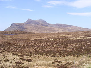
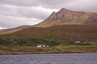
View of Cùl Beag from the south west, April 2009
Highest point
Elevation 769 m (2,523 ft)
Prominence 546 m (1,791 ft) [1]
Listing Marilyn, Corbett
Coordinates 58°01′46″N5°09′03″W / 58.02945°N 5.15091°W / 58.02945; -5.15091 Coordinates: 58°01′46″N5°09′03″W / 58.02945°N 5.15091°W / 58.02945; -5.15091
Naming
Translationsmall back(Gaelic)
Geography
Highland UK relief location map.jpg
Red triangle with thick white border.svg
Cùl Beag
United Kingdom relief location map.jpg
Red triangle with thick white border.svg
Cùl Beag
Cùl Beag (the United Kingdom)
OS grid NC140088
Topo map OS Landranger 15, Explorer 439

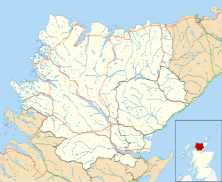
Cùl Beag is a mountain in Coigach, in the Northwest Highlands of Scotland. It is 15 km north of Ullapool and lies to the south of Cùl Mòr, and to the east of the more well known but lower Stac Pollaidh.

Coigach peninsula in the Northwest Highlands of Scotland

Coigach refers to the peninsula north of Ullapool, in Wester Ross in the Northwest Highlands of Scotland. The area consists of a traditional crofting and fishing community of a couple of hundred houses located between mountain and shore on a peninsula looking over the Summer Isles and the sea. The main settlement is Achiltibuie. Like its northerly neighbour, Assynt in Sutherland, Coigach has mountains which rise sharply from quiet, lochan-studded moorland, and a highly indented rocky coast with many islands, bays and headlands. The highest summit is Ben Mor Coigach at 743 metres; the distinctive profile of Stac Pollaidh is the other main peak within Coigach. The scenic qualities of Coigach, along with neighbouring Assynt, have led to the area being designated as the Assynt-Coigach National Scenic Area, one of 40 such areas in Scotland.

The Northwest Highlands are located in the northern third of Scotland that is separated from the Grampian Mountains by the Great Glen. The region comprises Wester Ross, Assynt, Sutherland and part of Caithness. The Caledonian Canal, which extends from Loch Linnhe in the south-west, via Loch Ness to the Moray Firth in the north-east splits this area from the rest of the country. The city of Inverness and the town of Fort William serve as gateways to the region from the south.

Scotland Country in Europe, part of the United Kingdom

Scotland is a country that is part of the United Kingdom. Sharing a border with England to the southeast, Scotland is otherwise surrounded by the Atlantic Ocean to the north and west, by the North Sea to the northeast and by the Irish Sea to the south. In addition to the mainland, situated on the northern third of the island of Great Britain, Scotland has over 790 islands, including the Northern Isles and the Hebrides.

Cùl Beag is within the Drumrunie Estate, which was purchased in a community buyout in 2005. It is now owned by the Assynt Foundation. [2]

Related Research Articles

Sutherland Historic county in Scotland

Sutherland is a historic county, registration county and lieutenancy area in the Highlands of Scotland. Its county town is Dornoch. Sutherland borders Caithness to the east, Ross-shire to the south and the Atlantic to the north and west. Like its southern neighbour Ross-shire, Sutherland has some of the most dramatic scenery in the whole of Europe, especially on its western fringe where the mountains meet the sea. These include high sea cliffs, and very old mountains composed of Precambrian and Cambrian rocks.

Summer Isles an archipelago lying in the mouth of Loch Broom, in the Highland region of Scotland.

The Summer Isles are an archipelago lying in the mouth of Loch Broom, in the Highland region of Scotland.

Suilven mountain in the United Kingdom

Suilven is one of the most distinctive mountains in Scotland. Lying in a remote area in the west of Sutherland, it rises almost vertically from a wilderness landscape of moorland, bogs, and lochans known as Inverpolly National Nature Reserve.

Inverpolly

Inverpolly is the name given to a large area of northern Wester Ross in the Northwest Highlands of Scotland, north of Ullapool. The area contains several prominent hills, rising up from a rough landscape of bogs and lochans. For many years the area was designated National Nature Reserve but since 2004, the designation has been limited to the area of Knockan Crag.

Eas a Chual Aluinn waterfall

Eas a' Chual Aluinn in the parish of Assynt, Sutherland, Highland, Scotland, is the highest waterfall in the United Kingdom with a sheer drop of 658 ft (200 m). When in full flow it is over three times higher than Niagara Falls.

Assynt Sparsely populated area of Sutherland on the west coast of Scotland

Assynt is a sparsely populated area in the south-west of Sutherland, lying north of Ullapool on the west coast of Scotland. Assynt is known for its landscape and its remarkable mountains, which have led to the area, along with neighbouring Coigach, being designated as the Assynt-Coigach National Scenic Area, one of 40 such areas in Scotland.

Quinag mountain in the United Kingdom

The hill Quinag in Sutherland, in the Scottish Highlands, is in fact a range of hills with an undulating series of peaks along its Y-shaped crest. The name Quinag is an anglicisation of the Gaelic name Cuinneag, a milk pail, reflecting its distinctive shape.

Clan MacLeod of Lewis Scottish clan

Clan MacLeod of The Lewes, commonly known as Clan MacLeod of Lewis, is a Highland Scottish clan, which at its height held extensive lands in the Western Isles and west coast of Scotland. From the 14th century up until the beginning of the 17th century there were two branches of Macleods: the MacLeods of Dunvegan and Harris ; and the Macleods of Lewis. In Gaelic the Macleods of Lewis were known as Sìol Thorcaill, and the MacLeods of Dunvegan and Harris were known as Sìol Thormoid.

Ben More Assynt mountain in the United Kingdom

Ben More Assynt is a mountain in Assynt in the far north-west of Scotland, 30 kilometres (19 mi) north-north-east of the town of Ullapool. The name translates as "big mountain of Assynt", and with a height of 998 metres (3,274 ft) it is the highest point in the county of Sutherland.

Novar House

Novar House is an 18th-century building, located 0.7 miles north of the village of Evanton in Ross, Scotland. It is built on the site of an earlier castle.

Canisp mountain in the United Kingdom

Canisp is a mountain in the far north west of Scotland. It is situated in the parish of Assynt, in the county of Sutherland, 25 kilometres north of the town of Ullapool. Canisp reaches a height of 847 metres (2779 feet) and qualifies as a Corbett and Marilyn hill. The mountain's name translates from the Old Norse language as “White Mountain”.

Calbha Beag

Calbha Beag is an uninhabited island in Eddrachillis Bay, off Sutherland, Highland, Scotland. It is immediately to the west of Calbha Mor.

Cùl Mòr mountain in the United Kingdom

Cùl Mòr is a shapely, twin summited mountain in the far north west of Scotland whose higher summit is the highest point of Inverpolly. It is almost completely separated from its southern neighbour, Cùl Beag. Despite its higher altitude, it is less well known than two of its other neighbours, Suilven and Stac Pollaidh, but being higher, it commands views over these and other neighbours.

<i>Zip n Zoo</i> 2008 film

Zip 'n Zoo is a 2008 film directed by Bruce Robertson, starring John Hannah, Simone Lahbib and Remy Bennett. The name of the film is derived from the sound of casting during fly-fishing.

Drumbeg, Sutherland village in Highland, Scotland

Drumbeg is a remote crofting village on the north west coast of Scotland in Assynt, Sutherland, Scottish Highlands and is in the Scottish council area of Highland.

Culkein human settlement in United Kingdom

Culkein Stoer is a remote former fishing village, centred on the Bay of Culkein, in Assynt in Sutherland, Scottish Highlands and is in the Scottish council area of Highland.

Culkein Drumbeg human settlement in United Kingdom

Culkein Drumbeg is a remote village on the north west coast of Scotland. It is located 0.93 miles (1.50 km) north west of Drumbeg in Assynt, Sutherland, in the Highland council area.

References

  1. Database of British and Irish Hills. Retrieved 20 Jan 2012
  2. "Assynt group buys estates in deal". BBC News. 3 June 2005. Retrieved 19 May 2013.