Zalipie is a village in Poland, in Gmina Olesno, Dąbrowa County, Lesser Poland Voivodeship. It is approximately 7 kilometres (4 mi) west of Olesno, 13 km (8 mi) north-west of Dąbrowa Tarnowska, and 68 km (42 mi) east of the regional capital Kraków.
Gmina Bolesław is a rural gmina in Dąbrowa County, Lesser Poland Voivodeship, in southern Poland. Its seat is the village of Bolesław, which lies approximately 15 kilometres (9 mi) north-west of Dąbrowa Tarnowska and 73 km (45 mi) east of the regional capital Kraków.
Gmina Mędrzechów is a rural gmina in Dąbrowa County, Lesser Poland Voivodeship, in southern Poland. Its seat is the village of Mędrzechów, which lies approximately 14 kilometres (9 mi) north of Dąbrowa Tarnowska and 76 km (47 mi) east of the regional capital Kraków.

Dąbrowa Rusiecka is a village in the administrative district of Gmina Rusiec, within Bełchatów County, Łódź Voivodeship, in central Poland. It lies approximately 3 kilometres (2 mi) north-west of Rusiec, 30 km (19 mi) west of Bełchatów, and 62 km (39 mi) south-west of the regional capital Łódź.
Ujście Jezuickie is a village in the administrative district of Gmina Gręboszów, within Dąbrowa County, Lesser Poland Voivodeship, in southern Poland. It lies approximately 20 kilometres (12 mi) north-west of Dąbrowa Tarnowska and 62 km (39 mi) east of the regional capital Kraków.
Wola Gręboszowska is a village in the administrative district of Gmina Gręboszów, within Dąbrowa County, Lesser Poland Voivodeship, in southern Poland. It lies approximately 17 kilometres (11 mi) north-west of Dąbrowa Tarnowska and 65 km (40 mi) east of the regional capital Kraków.
Wólka Grądzka is a village in the administrative district of Gmina Mędrzechów, within Dąbrowa County, Lesser Poland Voivodeship, in southern Poland. It lies approximately 10 kilometres (6 mi) north of Dąbrowa Tarnowska and 77 km (48 mi) east of the regional capital Kraków.
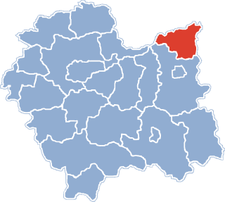
Adamierz is a village in the administrative district of Gmina Olesno, within Dąbrowa County, Lesser Poland Voivodeship, in southern Poland. It lies approximately 3 kilometres (2 mi) south-west of Olesno, 8 km (5 mi) north-west of Dąbrowa Tarnowska, and 71 km (44 mi) east of the regional capital Kraków.
Ćwików is a village in the administrative district of Gmina Olesno, within Dąbrowa County, Lesser Poland Voivodeship, in southern Poland. It lies approximately 4 kilometres (2 mi) north-west of Olesno, 10 km (6 mi) north-west of Dąbrowa Tarnowska, and 72 km (45 mi) east of the regional capital Kraków.
Niwki is a village in the administrative district of Gmina Olesno, within Dąbrowa County, Lesser Poland Voivodeship, in southern Poland. It lies approximately 6 kilometres (4 mi) west of Olesno, 12 km (7 mi) north-west of Dąbrowa Tarnowska, and 68 km (42 mi) east of the regional capital Kraków.
Oleśnica is a village in the administrative district of Gmina Olesno, within Dąbrowa County, Lesser Poland Voivodeship, in southern Poland. It lies approximately 6 kilometres (4 mi) south of Olesno, 4 km (2 mi) west of Dąbrowa Tarnowska, and 72 km (45 mi) east of the regional capital Kraków.

Olesno is a village in Dąbrowa County, Lesser Poland Voivodeship, in southern Poland. It is the seat of the gmina called Gmina Olesno. It lies approximately 7 kilometres (4 mi) north-west of Dąbrowa Tarnowska and 74 km (46 mi) east of the regional capital Kraków.
Pilcza Żelichowska is a village in the administrative district of Gmina Olesno, within Dąbrowa County, Lesser Poland Voivodeship, in southern Poland. It lies approximately 5 kilometres (3 mi) west of Olesno, 10 km (6 mi) north-west of Dąbrowa Tarnowska, and 69 km (43 mi) east of the regional capital Kraków.
Podborze is a village in the administrative district of Gmina Olesno, within Dąbrowa County, Lesser Poland Voivodeship, in southern Poland. It lies approximately 2 kilometres (1 mi) east of Olesno, 7 km (4 mi) north-west of Dąbrowa Tarnowska, and 75 km (47 mi) east of the regional capital Kraków.
Swarzów is a village in the administrative district of Gmina Olesno, within Dąbrowa County, Lesser Poland Voivodeship, in southern Poland. It lies approximately 3 kilometres (2 mi) south-east of Olesno, 5 km (3 mi) north-west of Dąbrowa Tarnowska, and 74 km (46 mi) east of the regional capital Kraków.
Boroszów is a village in the administrative district of Gmina Olesno, within Olesno County, Opole Voivodeship, in south-western Poland. It lies approximately 9 kilometres (6 mi) north of Olesno and 48 km (30 mi) north-east of the regional capital Opole.
Ligota Oleska is a village in the administrative district of Gmina Radłów, within Olesno County, Opole Voivodeship, in south-western Poland. It lies approximately 3 kilometres (2 mi) north-west of Radłów, 11 km (7 mi) north-east of Olesno, and 52 km (32 mi) north-east of the regional capital Opole.
Bobrowa is a village in the administrative district of Gmina Rudniki, within Olesno County, Opole Voivodeship, in south-western Poland. It lies approximately 7 kilometres (4 mi) south-east of Rudniki, 20 km (12 mi) north-east of Olesno, and 61 km (38 mi) north-east of the regional capital Opole.
Stary Bugaj is a village in the administrative district of Gmina Rudniki, within Olesno County, Opole Voivodeship, in south-western Poland. It lies approximately 6 kilometres (4 mi) south of Rudniki, 20 km (12 mi) north-east of Olesno, and 61 km (38 mi) north-east of the regional capital Opole.