
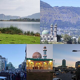
Gondar, also spelled Gonder, is a city and woreda in Ethiopia. Located in the North Gondar Zone of the Amhara Region, Gondar is north of Lake Tana on the Lesser Angereb River and southwest of the Simien Mountains. As of 2023, Gondar has an estimated population of 487,224.

Weldiya or Woldia is a town, woreda, and capital of the North Wollo Zone in northern Ethiopia. Located north of Dessie and southeast of Lalibela in the Amhara Region, this town has an elevation of 2112 meters above sea level.
Metemma, also known as Metemma Yohannes, is a town in northwestern Ethiopia, on the border with Sudan. Located in the Semien Gondar Zone of the Amhara Region, Metemma has a latitude and longitude of 12°58′N36°12′E with an elevation of 685 meters above sea level. Across the border is the corresponding Sudanese village of Gallabat. According to the British diplomat Hormuzd Rassam, who travelled through Metemma in November 1865 on his diplomatic mission to Emperor Tewodros II, "Metemma" comes from the Arabic for "the place of cutting, or termination – indicating the end of the Muslim provinces", although at the time the settlement was better known as Suk ul-Gallabat.
Dessie is a town in north-central Ethiopia. Located in the South Wollo Zone of the Amhara Region, it sits at a latitude and longitude of 11°8′N39°38′E, with an elevation between 2,470 and 2,550 metres above sea level. Dessie is 400 km to the north of the capital Addis Ababa. It has a population of more than 200,000 people in over 30 wards.

Debre Tabor is a town and woreda in northern Ethiopia. Located in the Debub Gondar Zone of the Amhara Region, about 100 kilometers southeast of Gondar and 50 kilometers east of Lake Tana, this historic town has a latitude and longitude of 11°51′N38°1′E with an elevation of 2,706 metres (8,878 ft) above sea level. The presence of at least 48 springs in the area contributed to the development of Debre Tabor.

Debre Markos is a city, separate woreda, and administrative seat of the East Gojjam Zone in Amhara Region, Ethiopia.
North Gondar is a zone in the Amhara Region of Ethiopia. This zone is named for the city of Gondar, the capital of Ethiopia until the mid-19th century.

South Gondar is a Zone in the Ethiopian Amhara Region. This zone is named for the city of Gondar, which was the capital of Ethiopia until the mid-19th century, and has often been used as a name for the local province.
Jan Amora is one of the woredas in the Amhara Region of Ethiopia. Part of the Semien Gondar Zone, Jan Amora is bordered on the south by Misraq Belessa, on the southwest by Wegera, on the west by Debarq, on the north by Addi Arkay and Tselemt, on the east by Beyeda, and on the southeast by Wag Hemra Zone. The administrative center of Jan Amora is Mekane Berhan.
Debarq is one of the woredas in the Amhara Region of Ethiopia. It is named after its largest town, Debarq. Part of the Semien Gondar Zone, Debarq is bordered on the south by Dabat,
Dabat is a woreda in Amhara Region, Ethiopia. Part of the Semien Gondar Zone, Dabat is bordered on the south by Wegera, on the west by Tach Armachiho, on the northwest by Tegeda, and on the northeast by Debarq. Towns in Dabat include Dabat and Wekin.
Wegera or Wogera, is a woreda in Amhara Region, Ethiopia. Wegera is named for the former province Wegera, which was located roughly in the same location, and was later made part of the province of Semien. Part of the Semien Gondar Zone, Wegera is bordered on the south by Mirab Belessa, on the southwest by Gondar Zuria, on the west by Lay Armachiho, on the northwest by Tach Armachiho, on the north by Dabat, on the northeast by Jan Amora, and on the southeast by Misraq Belessa. Towns in Wegera include Amba Giyorgis and Gedegbe.
Kemekem (also known as Libo Kemekem is one of the woredas in the Amhara Region of Ethiopia. Part of the Debub Gondar Zone, Kemekem is bordered on the south by the Reb

Debarq also spelled Dabareq and Debark, is a town in northern Ethiopia, 90 kilometers north-east of Gondar on the highway between Gondar and Axum, and is in the Semien Gondar Zone of the Amhara Region. It has a latitude and longitude of 13°08′N37°54′E and an elevation of 2850 meters above sea level.

Addis Zemen is a town in northern-central Ethiopia. Located in the Debub Gondar Zone of the Amhara Region, on the road connecting Gondar and Bahir Dar, Addis Zemen has a latitude and longitude of 12°07′N37°47′E and an elevation of 1975 meters above sea level. It is the administrative center of Kemekem woreda.
Woreta is a town in northern Ethiopia. Located in the Debub Gondar Zone of the Amhara Region, east of Lake Tana and south of Addis Zemen, this town has a latitude and longitude of 11°55′N37°42′E with an elevation of 1828 meters above sea level. It is the administrative center of Fogera woreda.
Dengel Ber is a town in western Ethiopia. Located on the south-western shore of Lake Tana in the Semien Gondar Zone of the Amhara Region, this town has a latitude and longitude of 11°57′N37°00′E. Access to this town includes track roads to both Shawra and Kunzela and weekly service by the Bahir Dar-Gorgora ferry on Lake Tana. While the name of the town is indisputably Amharic, there is some disagreement over the meaning of its name: while "Pass of the Virgin" has been the most common interpretation since at least the days James Bruce visited Ethiopia, Huntingford and Beckingham state that it means "pass of canna plants".
Tegede is one of the woredas in the Amhara Region of Ethiopia. Part of the Semien Gondar Zone, Tegeda is bordered on the south by Tach Armachiho, on the west by Mirab Armachiho, on the north by the Tigray Region, on the northeast by Debarq, and on the east by Dabat. Towns in Tegeda include Kirakir. Tegeda was part of former Sanja woreda.
Tselemt is one of the woredas in the Amhara Region of Ethiopia. Located at the northeastern point of the Semien Gondar Zone, Tselemt is bordered on the south by Beyeda, on the southwest by Jan Amora, on the west by Addi Arkay, and on the north and east by the Tigray Region. Tselemt was part of Addi Arkay woreda.
Tach Armachiho is one of the woredas in the Amhara Region of Ethiopia. This woreda is named after "Armachiho", a province in northwestern Ethiopia along the border with Sudan and south of the Tekezé River. Part of the Semien Gondar Zone, Tach Armachiho is bordered on the south by Lay Armachiho and Chilga, on the southwest by Metemma, on the west by Mirab Armachiho, on the north by the Tegeda, on the east by Dabat, and on the southeast by Wegera. Tach Armachiho was part of former Sanja woreda.


