
The Kingdom of Bhutan is divided into 20 districts. Bhutan is located between the Tibet Autonomous Region of China and India on the eastern slopes of the Himalayas in South Asia.

Elections in Bhutan are conducted at national (Parliamentary) and local levels. Suffrage is universal for citizens 18 and over, and under applicable election laws. In national elections, also known as the general elections, political party participation is mainly restricted to the lower house of Parliament, and by extension, to the executive nominated by its majority.
A gewog, in the past also spelled as geog, is a group of villages in Bhutan. The head of a gewog is called a gup. Gewogs form a geographic administrative unit below dzongkhag districts, and above Dzongkhag Thromde class B and Yenlag Thromde municipalities. Dzongkhag Thromde class A municipalities have their own independent local government body.
A dungkhag is a sub-district of a dzongkhag (district) of Bhutan. The head of a dungkhag is a Dungpa. As of 2007, nine of the twenty dzongkhags had from one to three dungkhags, with sixteen dungkhags in total.
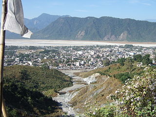
Phuntsholing, also spelled as Phuentsholing, is a border town in southern Bhutan and is the administrative seat of Chukha District. The town occupies parts of both Phuentsholing Gewog and Sampheling Gewog.
Jakar is a town in the central-eastern region of Bhutan. It is the district capital of Bumthang District and the location of Jakar Dzong, the regional dzong fortress. The name Jakar roughly translates as "white bird" in reference to its foundation myth, according to which a roosting white bird signalled the proper and auspicious location to found a monastery around 1549.

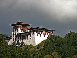
Wangdue Phodrang is a town and capital of Wangdue Phodrang District in central Bhutan. It is located in Thedtsho Gewog.
Zhemgang is a town in Zhemgang District, Bhutan. It is the capital of the district, and is located in Trong Gewog.
The development of Bhutanese democracy has been marked by the active encouragement and participation of reigning Bhutanese monarchs since the 1950s, beginning with legal reforms such as the abolition of slavery, and culminating in the enactment of Bhutan's Constitution. The first democratic elections in Bhutan began in 2007, and all levels of government had been democratically elected by 2011. These elections included Bhutan's first ever partisan National Assembly election. Democratization in Bhutan has been marred somewhat by the intervening large-scale expulsion and flight of Bhutanese refugees during the 1990s; the subject remains somewhat taboo in Bhutanese politics.
Chiwogs of Bhutan or chios refer to the 1044 basic electoral precincts of Bhutan. Chiwogs are also former third-level administrative divisions of Bhutan below gewogs. Until 2009, they were the equivalent of municipalities or parishes, containing clusters of villages and hamlets. There are generally 5 or 6 chios in each geo, and in turn several geos in each dzongkha (district). To illustrate, there are 50 chios in Paro District alone. The majority of chios are small rural communities; more densely populated areas tend to be separate thromdes, or municipalities. A Chiwog Disaster Management Plan (CDMP) exists in some chios to form an effective responsive to any local disasters. Often, participants in the CDMP are also trained at a geo level for better coordination.
Darkarla Gewog is a gewog of Thimphu District, Bhutan.
Lhamoy Zingkha Gewog is a gewog of Dagana District, Bhutan. It also comprises part of Lhamoy Zingkha Dungkhag (sub-district), along with Deorali and Nichula Gewogs.
Nichula Gewog is a gewog of Dagana District, Bhutan. It also comprises part of Lhamoy Zingkha Dungkhag (sub-district), along with Lhamoy Zingkha and Deorali Gewogs.
The Local Government Act of Bhutan was enacted on September 11, 2009, by parliament of Bhutan in order to further implement its program of decentralization and devolution of power and authority. It is the most recent reform of the law on Bhutan's administrative divisions: Dzongkhags, Dungkhags, Gewogs, Chiwogs, and Thromdes (municipalities). The Local Government Act of Bhutan has been slightly amended in 2014.
A thromde is a second-level administrative division in Bhutan. The legal administrative status of thromdes was most recently codified under the Local Government Act of 2009, and the role of thromdes in elections in Bhutan was defined in the Election Act of 2008
The Bhutanese local government elections of 2011 were originally slated for 2008, but were delayed until 2011. Elections began on January 20, 2011, however polls opened in only 3 of 20 districts – Thimphu, Chukha District (Phuentsholing), and Samdrup Jongkhar – as part of a staggered election schedule. Polls closed June 27, 2011. Ahead of elections, 1,042 chiwogs, the basis of Bhutan's single-constituency electoral scheme, were slated to elect the leadership of Dzongkhag, Gewog, and Thromde governments.


