
Dagapela is a settlement in the south of Bhutan. It is located in Dagana District, to the southeast of the town of Dagana. At the 2005 census, its population was 145. [1]
Dagapela is a settlement in the south of Bhutan. It is located in Dagana District, to the southeast of the town of Dagana. At the 2005 census, its population was 145. [1]

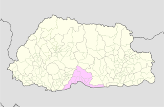
Dagana District is a district located in Bhutan. Most of the district is populated by Dzongkha speakers. However, in the southwest part near the Sarpang District, Nepali is also spoken as a native language.
Sarpang District is one of the 20 dzongkhags (districts) comprising Bhutan. Sarpang covers a total area of 1,946 sq km and stretches from Lhamoizhingkha in West Bhutan to Manas National Park in the east. Sarpang Dzongkhag is divided into one dungkhag, Gelephu, and 12 gewogs.

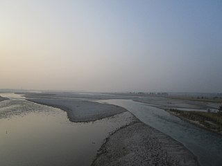
Mo Chhu is a major river in Bhutan. The word "Chhu" means "river" or "water" in Dzongkha, the official national language in Bhutan. The river rises in Gasa Dzongkhag (district) near the border between Bhutan and Tibet. From there, the Mo Chhu flows generally southward to Punakha in central Bhutan, where it joins the Pho Chhu from the northeast. The confluence of the two streams is immediately below the Punakha Dzong, which is the winter home of the Dratshang Lhentshog and the Je Khenpo. The combined streams are then joined by the Dang Chhu near the town of Wangdue Phodrang, and the name of the river becomes the Puna Tsang Chhu. The river then flows through Dagana and Tsirang Districts. After leaving Bhutan near the town of Kalikhola, the river enters Assam in India and is known as the Sankosh. The Sankosh ultimately empties into the Brahmaputra, flowing into the Bay of Bengal.

Sankosh is a river that rises in northern Bhutan and empties into the Brahmaputra in the state of Assam in India. In Bhutan, it is known as the Puna Tsang Chu below the confluences of several tributaries near the town of Wangdue Phodrang.
Hasimara is a town in the bank of River Torsha in Alipurduar district of West Bengal state, India near the border with Bhutan. It is located at 26° 45' N latitude and 89° 21' E longitude at an altitude of 109 metres above sea level and has a population of about 40,000.
Daga , also officially referred to as Dagana, is a town in Goshi Gewog, Dagana District in southwestern Bhutan. It is the administrative capital, Dzongkhag Thromde, of the district.
Darkarla Gewog is a gewog of Thimphu District, Bhutan.
Dorona Gewog is a gewog of Dagana District, Bhutan. It also comprises part of Dagapela Dungkhag, along with Goshi and Tashiding Gewogs.
Gesarling Gewog is a gewog of Dagana District, Bhutan.
Karna Gewog is a gewog of Dagana District, Bhutan.
Khebisa Gewog is a gewog of Dagana District, Bhutan.
Lajab Gewog is a gewog of Dagana District, Bhutan.
Tashiding Gewog is a gewog of Dagana District, Bhutan. It also comprises part of Dagapela Dungkhag (sub-district), along with Dorona and Goshi Gewogs.
Tsangkha Gewog is a gewog of Dagana District, Bhutan.
Tsendagang Gewog is a gewog of Dagana District, Bhutan.
Tseza Gewog is a gewog of Dagana District, Bhutan.
Lhamoy Zingkha Gewog is a gewog of Dagana District, Bhutan. It also comprises part of Lhamoy Zingkha Dungkhag (sub-district), along with Deorali and Nichula Gewogs.
Nichula Gewog is a gewog of Dagana District, Bhutan. It also comprises part of Lhamoy Zingkha Dungkhag (sub-district), along with Lhamoy Zingkha and Deorali Gewogs.
Deorali Gewog is a former gewog of Dagana District, Bhutan. It also comprises part of Lhamoy Zingkha Dungkhag, along with Lhamoy Zingkha and Nichula Gewogs.
Karmaling Gewog is a gewog of Dagana District, Bhutan.
Coordinates: 26°56′N89°57′E / 26.933°N 89.950°E
| | This Bhutan location article is a stub. You can help Wikipedia by expanding it. |