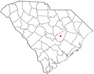
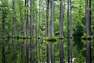
Daisy Swamp is a swamp in Berkeley County, South Carolina, in the United States. [1]
A swamp is a wetland that is forested. Many swamps occur along large rivers where they are critically dependent upon natural water level fluctuations. Other swamps occur on the shores of large lakes. Some swamps have hammocks, or dry-land protrusions, covered by aquatic vegetation, or vegetation that tolerates periodic inundation or soil saturation. The two main types of swamp are "true" or swamp forests and "transitional" or shrub swamps. In the boreal regions of Canada, the word swamp is colloquially used for what is more correctly termed a bog, fen, or muskeg. The water of a swamp may be fresh water, brackish water or seawater. Some of the world's largest swamps are found along major rivers such as the Amazon, the Mississippi, and the Congo.
Berkeley County is a county in the U.S. state of South Carolina. As of the 2010 census, its population was 177,843. Its county seat is Moncks Corner. After two previous incarnations of Berkeley County, the current county was created in 1882.
The United States of America (USA), commonly known as the United States or America, is a country composed of 50 states, a federal district, five major self-governing territories, and various possessions. At 3.8 million square miles, the United States is the world's third or fourth largest country by total area and is slightly smaller than the entire continent of Europe's 3.9 million square miles. With a population of over 327 million people, the U.S. is the third most populous country. The capital is Washington, D.C., and the largest city by population is New York City. Forty-eight states and the capital's federal district are contiguous in North America between Canada and Mexico. The State of Alaska is in the northwest corner of North America, bordered by Canada to the east and across the Bering Strait from Russia to the west. The State of Hawaii is an archipelago in the mid-Pacific Ocean. The U.S. territories are scattered about the Pacific Ocean and the Caribbean Sea, stretching across nine official time zones. The extremely diverse geography, climate, and wildlife of the United States make it one of the world's 17 megadiverse countries.
Daisy Swamp was named for the Deas family of landowners. [2]
Craven County is a county located in the U.S. state of North Carolina. As of the 2010 Census, the population was 103,505. Its county seat is New Bern. The county was created in 1705 as Archdale Precinct from the now-extinct Bath County. It was renamed Craven Precinct in 1712 and gained county status in 1739. It is named for William, Earl of Craven, who lived from 1606-1697.
Bolivia is a town in Brunswick County, North Carolina, United States. The population was 143 at the 2010 census. It is the county seat of Brunswick County. Bolivia is part of the Myrtle Beach metropolitan area.

Manning is a city in and the county seat of Clarendon County, South Carolina, United States. The population was 4,108 as of the 2010 census, with an estimated population in 2014 of 4,059. It was named after former South Carolina governor John Laurence Manning.
Summerton is a town in Clarendon County, South Carolina, United States. The population was 1,000 at the 2010 census.
Kingstree is a city and the county seat of Williamsburg County, South Carolina, United States. The population was 3,328 at the 2010 census.
Audubon Swamp Garden is a 60-acre (24 ha) cypress and tupelo swamp on the grounds of Magnolia Plantation near Charleston, South Carolina. At one time, the swamp served as a reservoir for the plantation's rice cultivation. The swamp garden includes native flora and non-native, exotic plantings and is home to herons, ibis, turtles, otters, alligators, and other wildlife.
Ashepoo River is a short blackwater river in South Carolina, United States. It rises in a confluence of swamps south of Walterboro, flows in a southeast direction and empties into Saint Helena Sound at 32.49°N 80.42389°W. The entire course of the river lies within the boundaries of Colleton County.
Cypress Gardens is a 170-acre (69 ha) preserve and gardens located at 3030 Cypress Gardens Road, Moncks Corner, South Carolina, United States. The centerpiece of the garden is the 80 acres (32 ha) blackwater bald cypress/tupelo swamp, surrounded with both boat and foot trails.
WRIE is a sports talk formatted radio station known as Sports Radio AM 1260: The Score in Erie, Pennsylvania. The station is owned and operated by Cumulus Media. The station is part of the Pittsburgh Penguins, the Cleveland Browns, and the Cleveland Indians Radio Network. Operations as an ESPN Radio affiliate have been in place since January 29, 2007. On January 2, 2013, WRIE switched to CBS Sports Radio because of a decision by parent company Cumulus Media.
The Salkehatchie River originates near the City of Barnwell, South Carolina and accepts drainage from Turkey Creek and Whippy Swamp before merging with the Little Salkehatchie River to form the Combahee River Basin, which empties into Saint Helena Sound and the Atlantic Ocean. Prior to the confluence, the Little Salkehatchie River accepts drainage from Lemon Creek, Buckhead Creek, and Willow Swamp.
The High Hills of Santee, sometimes known as the High Hills of the Santee, is a long, narrow hilly region in the western part of Sumter County, South Carolina. It has been called "one of the state's most famous areas". The High Hills of Santee region lies north of the Santee River and east of the Wateree River, one of the two rivers that join to form the Santee. It extends north almost to the Kershaw county line and northeasterly to include the former summer resort town of Bradford Springs. Since 1902 the town has been included in Lee County.
Level Run is an unincorporated community in Pittsylvania County, in the U.S. state of Virginia.
Mount Holly is an unincorporated community in Berkeley County, South Carolina just north of Goose Creek, South Carolina.
Dale, South Carolina, is an unincorporated community located in northern Beaufort County in the southern corner of the state of South Carolina, U.S.A. It is located approximately five miles north of Beaufort, South Carolina on U.S. Route 21, designated the Trask Parkway in that area. The zip code for Dale, South Carolina, is 29914.
Hubbells Corner is an unincorporated community in Dearborn County, Indiana, in the United States.
Pigeonroost is an unincorporated community in Mitchell County, North Carolina, in the United States.
Strawberry is an unincorporated community in Berkeley County, in the U.S. state of South Carolina.
Rock Hill is an unincorporated community in Ohio Township, Spencer County, in the U.S. state of Indiana.
Vincit is an unincorporated community in Dunklin County, in the U.S. state of Missouri.
Rose Hill is an unincorporated community in Johnson County, in the U.S. state of Missouri.
| This South Carolina state location article is a stub. You can help Wikipedia by expanding it. |