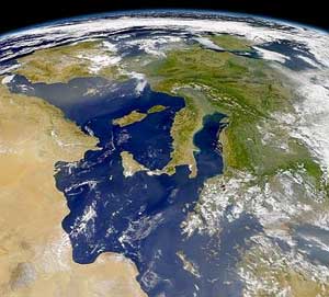
Italy is located in southern Europe and comprises the long, boot-shaped Italian Peninsula, the southern side of Alps, the large plain of the Po Valley and some islands including Sicily and Sardinia. Corsica, although belonging to the Italian geographical region, has been a part of France since 1769. Italy is part of the Northern Hemisphere.

Danyang County (Danyang-gun) is in North Chungcheong Province, South Korea.
Namhan Mountain is a 460 m peak in Gyeonggi-do province, South Korea. It lies on the border between southern Seoul and the city of Gwangju.

Guri is a city in Gyeonggi Province, South Korea. It is located immediately to the east of Seoul, in the heart of the Capital Metropolitan Area.

Yeoju is a city in Gyeonggi Province, South Korea. Yeoju was a county but was raised to the status of a city in September 2013. Together with the neighboring city of Icheon, it is known as a major center of contemporary South Korean ceramics, and hosts the World Ceramic Exposition every year. Other local products of note include rice, sweet potatoes, and yellow melons. Yeoju is the birthplace of Korea's last queen, Empress Myeongseong.

The Ussuri River or Wusuli River, runs through Khabarovsk and Primorsky Krais, Russia, and the southeast region of Northeast China. It rises in the Sikhote-Alin mountain range, flowing north and forming part of the Sino-Russian border until it joins the Amur River as a tributary to it at Khabarovsk. It is approximately 897 kilometers (557 mi) long. The Ussuri River drains the Ussuri basin, which covers 193,000 square kilometers (75,000 sq mi). Its waters come from rain (60%), snow (30–35%) and subterranean springs. The average discharge is 1,150 cubic metres per second (41,000 cu ft/s) and the average elevation is 1,682 metres (5,518 ft).
The name Seowoncheon is also applied to the portion of the Jungnangcheon which separates Seoul from Gyeonggi Province.

The Bukhan River is a tributary of the Han River that flows through both North and South Korea. It traverses Kangwon province in North Korea and Gangwon and Gyeonggi provinces in South Korea.

Shilleuksa is a Korean Buddhist temple situated against a low hill on the north side of the river Namhan, three kilometers east of Yeoju in Gyeonggi Province, approximately one-hour southeast of Seoul. The only riverside temple in Korea, Shilleuksa is a sacred pilgrimage site and a repository of seven Treasures. A 500-year-old aromatic juniper tree and a 600-year-old ginkgo tree stand on the temple grounds.

The Vara is a river of the Province of La Spezia in Liguria, north-west Italy.
The Maclaughlin River, a perennial river of the Snowy River catchment, is located in the Monaro region of New South Wales, Australia.
The Mowbray River is a river of the south Canterbury Region of New Zealand's South Island. A short upper tributary of the Orari River, it flows north from its sources in the Four Peaks Range northeast of Fairlie.
Namgunjasan is a mountain of South Korea. It has an elevation of 836 metres.

Põlgaste is a village in Kanepi Parish, Põlva County in southeastern Estonia.
Namhan River is a river of South Korea. It is a tributary of the Han River. The stream was found to be contaminated by bis(2-ethylhexyl) phthalate (DEHP) with 50 ppb. The stream has clear water and serves as a source of water for the Seoul. A popular bike path follows the river.
Heukcheon is a river of South Korea. It is a river of the Han River system and is a tributary of the Namhan River. The basin area is 314.02 km 2 and the total length is 37 km. Topographically, black forests are the largest part of the watershed with 73.92% and the agricultural area is 7.17%. The upper part of the river consists of gravel, pumice stone and rock. The river is highly affected by nonpoint pollution sources.
Miho-cheon (Korean:미호천), a tributary of Geum River, is a river beginning in Eumseong in Chungcheongbuk-do. Its length is about 37.5 km

Seven-story Stone Pagoda in Tappyeong-ri, Chungju, also called the Jungang Pagoda, is a 14.5 meter tall stone pagoda near the Namhan River in North Chungcheong Province, South Korea. It is the tallest stone pagoda of the Later Silla period.


