Daleli

Last updated
Daleli
Village
Kanepokhari sketch map.svg
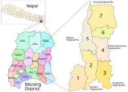
Kanepokhari. Daleli is in Ward 2.
Coordinates: 26°33′13″N87°29′40″E / 26.553513°N 87.494360°E / 26.553513; 87.494360 Coordinates: 26°33′13″N87°29′40″E / 26.553513°N 87.494360°E / 26.553513; 87.494360
CountryFlag of Nepal.svg    Nepal
Province Province No. 1
District Morang District
Gaunpalika Kanepokhari
Population
 (2020)
  Total10,678
Time zone UTC+5:45 (Nepal Time)

Daleli Bajar is a village in the Kanepokhari Rural Municipality in the Morang District of Province No. 1, south-eastern Nepal. It is in Kanepokhari Ward 2, which had a population of 10678 in 2020.

Location

Daleli is in Nepal, Province 1, Morang, Kanepokhari. The elevation is about 891 metres (2,923 ft) above sea level. [1] The Köppen climate classification is Cwa: Monsoon-influenced humid subtropical climate. [2]

Google Maps shows Daleli on the Kanepokhari–Rangeli Road, south of Keroun Bazar. [3]

Daleli was in Keroun Ward 9.[ citation needed ] It is now in Kanepokhari Ward 2. [4] As of 2011 Kanepokhari Ward 2 had 1,368 households with a population of 5,941, of which 2,758 were male and 3,183 were female. [5]

The school Sikshya Bikash Ma V is in Kanepokhari-2, Daleli, Morang. [4]

Related Research Articles

Jhapa District A district in eastern Nepal

Jhapa is a district of Province No. 1 in eastern Nepal named after a Rajbanshi word "Jhapa" meaning "to cover" (verb). The latest official data, the 2011 Nepal Census, puts the total population of the district at 812,650. The total area of the district is 1606 square kilometres.

Morang District District in Nepal

Morang District is located in Province No. 1 in eastern Nepal. It is an Outer Terai district. It borders with Bihar, India to the South, Jhapa to the East, Dhankuta and Panchthar to the North, and Sunsari to the west. Morang has one metropolitan city (Biratnagar), eight municipalities and eight rural municipalities. The total area of Morang is 1,855 km2 (716 sq mi). The lowest elevation point is 60 meters and the highest is 2410 meters above sea level. The headquarters of Morang is connected by Koshi National Highway to the east–west Mahendra National Highway at Itahari, Sunsari, and Morang is also connected to the Hill parts of the eastern region of Nepal. Morang is the core industrial sector for the eastern region of Nepal.

Bayarban Village development committee in Koshi Zone, Nepal

Bayarban was a village development committee in the Morang District, Koshi Zone of south-eastern Nepal. It was named for the village of Bayarban Bazar. In 2017 it was absorbed by the newly created Kanepokhari Rural Municipality.

Hoklabari Village development committee in Koshi Zone, Nepal

Hoklabari was a village development committee in Morang District in the Koshi Zone of south-eastern Nepal. In 2017 it was absorbed by the newly created Kanepokhari Rural Municipality.

Keroun, Kanepokhari Village in Province No. 1, Nepal

Keroun Bazar is a village in Ward 2 of the Kanepokhari Rural Municipality of the Morang District in Province No. 1 of south-eastern Nepal. Keroun was formerly a Village development committee (VDC), but was incorporated into Kanepokhari when that rural municipality was created in 2017.

Letang Municipality Municipality in Koshi Zone, Nepal

Letang, "लेटाङ " is a Municipality in Morang District in the Province No. 1 of south-eastern Nepal. It was formed by merging the existing Village Development Committees of Letang, Jante, Warrangi and Bhogateni.

Ramailo, Nepal village in Province No. 1, Nepal

Ramailo is a village that was in the Bayarban village development committee until 2017 and is now in the Kanepokhari Rural Municipality. This is in the Morang District of Province No. 1, south-eastern Nepal. It is the center of Kanepokhari Ward 6, which had a population of 5,771 in 2011.

Kanepokhari Rural Municipality Gaupalika in Province No. 1, Nepal

Kanepokhari Rural Municipality is a Gaunpalika located in the center of Morang District, Province No. 1, Nepal.

Aitabare, Kanepokhari Village in Province No. 1, Nepal

Aitabare or Aaitabare is a market village that is the center of Ward 7 of the Kanepokhari Rural Municipality of the Morang District in Province No. 1 of south-eastern Nepal. The population of Kanepokhari Ward 7 in 2011 was 4,241.

Bhausabari Village in Province No. 1, Nepal

Bhausabari Bajar is a village in the Kanepokhari Rural Municipality in the Morang District of Province No. 1, south-eastern Nepal. It is the center of Kanepokhari Ward 5, which had a population of 6,776 in 2011.

Bihibare Village development committee in Province No. 1, Nepal

Bihibare is a village in the Kanepokhari Rural Municipality in the Morang District of Province No. 1, south-eastern Nepal. It is the center of Kanepokhari Ward 6, which had a population of 5,771 in 2011.

Harakpur Place in Province No. 1, Nepal

Harakpur is a village in Ward 3 of the Kanepokhari Rural Municipality of the Morang District in Province No. 1 of south-eastern Nepal.

Province No. 1 Province of Nepal

Province No. 1 is the easternmost of the seven provinces established by the new constitution of Nepal which was adopted on 20 September 2015. The province covers an area of 25,905 km2, about 17.5% of the country's total area. With the industrial city of Biratnagar as its headquarter, the province covers other major eastern towns including Damak, Dharan, Itahari, Inaruwa and Birtamod and includes several mountains including the Everest, Kanchenjunga, and Ama Dablam. Koshi – the largest river of the nation, circumvents the province's western boundary. Adhering to the first-past-the-post voting system issued by the Constituency Delimitation Commission, the province hosts 28 parliamentary seats and 56 provincial seats.

Ratuwamai Municipality Municipality in Province No. 1, Nepal

Ratuwamai is a municipality and rural town situated in south-eastern Terai in Morang district and Province No. 1 of Nepal. This municipality was formed merging six village development committee i.e. Sijuwa, Itahara, Jhurkiya, Mahadeva, Govindapur and Baradanga since March 2017. Total population is 55 thousand 3 hundred 80, area 142.15 km2 and the number of voters is 42 thousand 4 hundred. The main Occupation of this municipality is the Agriculture, most of the people earn money by farming. Sombare, Itahara, Laxmichock, Damravitta, Sijuwa, Sauntha, Shanichare, Govindapur, Kalyanpur and Jhurkiya are the most developing places in the Ratuwamai Municipality. The borders are as following: East Jhapa District, West Sunawarshi Municipality and Pathari-Sanischare Municipality, North Urlabari Municipality and South Bihar State India.

Sundar Haraicha Municipality Municipality in Province No. 1, Nepal

Sundar Haraicha is a municipality in Morang District of Province No. 1 in Nepal that was established on 10 March 2017 by merging the former municipalities Sundar Dulari and Koshi Haraicha. At the time of the 2011 Nepal census, the localities formed had a joint population of 80,518 people living in 18,610 individual households.

Sunawarshi Municipality Municipality in Province No. 1, Nepal

Sunawarshi is an urban municipality in Morang District of Province No. 1 of Nepal. It is one out of nine urban municipalities of Morang District.

Jahada Rural Municipality Rural Municipality in Province No. 1, Nepal

Jahada is a rural municipality (gaunpalika) out of eight rural municipality located in Laxminiya Bazzar Morang District of Province No. 1 of Nepal. There are a total of 17 municipalities in Morang in which 9 are urban and 8 are rural.

Kanepokhari (pond)

Kanepokhari is a pond that gives its name to the Kanepokhari Rural Municipality in Morang District, Province No. 1, Nepal.

Morang 2 (constituency)

Morang 2 is one of six parliamentary constituencies of Morang District in Nepal. This constituency came into existence on the Constituency Delimitation Commission (CDC) report submitted on 31 August 2017.

Morang 3 (constituency)

Morang 3 is one of six parliamentary constituencies of Morang District in Nepal. This constituency came into existence on the Constituency Delimitation Commission (CDC) report submitted on 31 August 2017.

References

  1. "Daleli Bajar", GeoNames
  2. "Daleli Bajar, Keroun, Morang, Kosī Zone, Purwanchal, Nepal", Mindat, retrieved 2020-06-11
  3. "Daleli", Google Maps, retrieved 2020-06-11
  4. 1 2 School Details vy Local Level and District, 2076 (PDF), p. 18, retrieved 2020-06-11
  5. Unit-9: Kanepokhari Gaunpalika (PDF), District Coordination Committee Office : Morang, Nepal, p. 10, retrieved 2020-06-11