

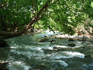
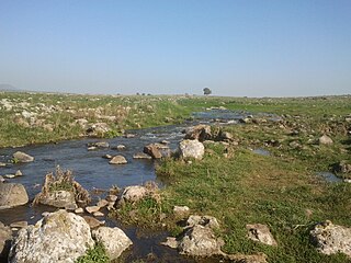
The Daliyot River (Hebrew: Nahal Daliyot) is a river in the Golan Heights. It flows from the Golan Heights plateau, through the Gamla Nature Reserve and down the western slopes of the Heights, and into the Sea of Galilee.
The Daliyot River (Hebrew: Nahal Daliyot) is a river in the Golan Heights. It flows from the Golan Heights plateau, through the Gamla Nature Reserve and down the western slopes of the Heights, and into the Sea of Galilee.
The Jordan River and the streams coming down from the Central Golan create a landscape of swamps and open water surfaces, variously called deltas, estuaries or lagoons.
The Daliyot River is one of five rivers running through the Bethsaida Valley [1] (Batikha or Buteikha in Arabic): the Jordan at the northern edge, Meshushim (Wadi el-Hawa in Arabic; collects the waters of the Katzrin Stream and Zavitan Stream ), Yehudiya (with Batra as a tributary), Daliyot - together they form the Meshushim and Zaki Lagoons before reaching the Sea of Galilee -, and Sfamnun.
The Daliyot River estuary, best known as Majrassa or Majrase, [2] is the largest freshwater nature reserve controlled by Israel. [1] It carries water from the Golan Heights and forms lagoons when it reaches the Sea of Galilee. [1]
The Majrase Nature Reserve stretches over 5000 dunams, some of it agricultural land. [1]

The geography of Israel is very diverse, with desert conditions in the south, and snow-capped mountains in the north. Israel is located at the eastern end of the Mediterranean Sea in West Asia. It is bounded to the north by Lebanon, the northeast by Syria, the east by Jordan and the West Bank, and to the southwest by Egypt. To the west of Israel is the Mediterranean Sea, which makes up the majority of Israel's 273 km (170 mi) coastline, and the Gaza Strip. Israel has a small coastline on the Red Sea in the south.

The Jordan River or River Jordan, also known as Nahr Al-Sharieat, is a 251-kilometre-long (156 mi) endorheic river in the Levant that flows roughly north to south through the Sea of Galilee and drains to the Dead Sea. The river passes by or through Jordan, Syria, Israel, and the Palestinian territories.
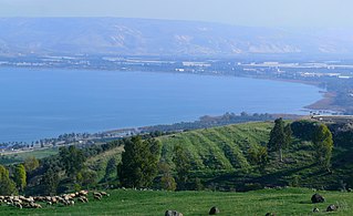
The Sea of Galilee, also called Lake Tiberias, Genezareth Lake or Kinneret, is a freshwater lake in Israel. It is the lowest freshwater lake on Earth and the second-lowest lake in the world, with its elevation fluctuating between 215 and 209 metres below sea level. It is approximately 53 km (33 mi) in circumference, about 21 km (13 mi) long, and 13 km (8.1 mi) wide. Its area is 166.7 km2 (64.4 sq mi) at its fullest, and its maximum depth is approximately 43 metres (141 ft). The lake is fed partly by underground springs, but its main source is the Jordan River, which flows through it from north to south with the outflow controlled by the Degania Dam.

Bethsaida, also known as Julias or Julia, is a place mentioned in the New Testament. Julias lay in an administrative district known as Gaulonitis. Historians have suggested that the name is also referenced in rabbinic literature under the epithet Ṣayḏān.

Geshur was a territory in the ancient Levant mentioned in the early books of the Hebrew Bible and possibly in several other ancient sources, located in the region of the modern-day Golan Heights. Some scholars suggest it was established as an independent city-state during the early Iron Age from the middle of the tenth century BCE, maintaining its autonomy for about a century until it was annexed in the third quarter of the ninth century by Hazael, the king of Aram-Damascus.
The Hasbani or Snir Stream, is the major tributary of the Jordan River that flows in Lebanon and Israel. Locals in the mid-19th century knew the Hasbani as the Upper Jordan River.

Mount Arbel is a mountain in The Lower Galilee near Tiberias in Israel, with high cliffs, views of Mount Hermon and the Golan Heights, a cave-fortress, and ruins of an ancient synagogue. Mount Arbel sits across from Mount Nitai; their cliffs were created as a result of the geological processes leading to the creation of the Jordan Rift Valley.

The Lower Galilee is a region within the Northern District of Israel. The Lower Galilee is bordered by the Jezreel Valley to the south; the Upper Galilee to the north, from which it is separated by the Beit HaKerem Valley; the Jordan Rift Valley with the Jordan River and the Sea of Galilee to the east; and to the west, a segment of the Northern Coastal Plain known as the Zvulun Valley, stretching between the Carmel ridge and Acre. The Lower Galilee is the southern part of the Galilee. In Josephus' time, it was known to stretch in breadth from Xaloth (Iksal) to Bersabe, and in length from Cabul to Tiberias, a region that contains around 470 km2. It is called "Lower" since it is less mountainous than the Upper Galilee. The peaks of the Lower Galilee rise to 500 m (1,600 ft) above sea level. The tallest peaks are Mount Kamon at the northern part of the Lower Galilee, and Mount Tabor in the southern part.
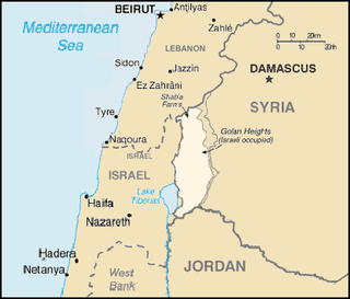
The Golan Heights, or simply the Golan, is a basaltic plateau at the southwest corner of Syria. It is bordered by the Yarmouk River in the south, the Sea of Galilee and Hula Valley in the west, the Anti-Lebanon mountains with Mount Hermon in the north and Wadi Raqqad in the east. It hosts vital water sources that feed the Hasbani River and the Jordan River. Two thirds of the area was occupied by Israel following the 1967 Six-Day War and then effectively annexed in 1981 – an action unrecognized by the international community, which continues to consider it Israeli-occupied Syrian territory. In 2024 Israel occupied the remaining one third of the area.

The Israel Nature and Parks Authority is an Israeli government organization that manages nature reserves and national parks in Israel, the Golan Heights and parts of the West Bank. The organization was founded in April 1998, merging two organizations that had managed the nature reserves and national parks separately since 1964. The director of the Authority is Raya Shurki.

Highway 87 is a 35 km long east-west highway in northern Israel and the Israeli-occupied Golan Heights. It extends from the northern shores of Lake Kinneret through the central Golan Heights. It begins in the west at Kfar Nahum/Capernaum and ends in the east at Bashan Junction.
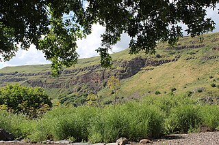
Gamla nature reserve is a nature reserve and archaeological site located in the center of the Golan Heights, about 20 km south to the Israeli settlement of Katzrin. It adjoins the Yehudiya Forest Nature Reserve.

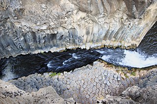
The Hexagon Pool is a natural pool by the Meshushim River in the Yehudiya Forest Nature Reserve, the central Golan Heights.

The Beit Netofa Valley, or Sahl al-Battuf is a valley in the Lower Galilee region of Israel, midway between Tiberias and Haifa. Covering 46 km2, it is the largest valley in the mountainous part of the Galilee and one of the largest in the southern Levant.

Nahal Kziv or the Horn Valley is a 39-kilometer long perennial stream in the Upper Galilee, Israel. During the winter, rainfall fills the channel, and springs along the riverbed add to the flow. Currently, Mekorot pumps the water of the river's principal spring, Ein Ziv, and supplies it to the residents of the Western Galilee, making the channel between Ein Ziv and Ein Tamir an intermittent stream. On the southern ridge overlooking the valley sits a 12th-century Crusader castle, Montfort, the old headquarters of the Teutonic Order in the Holy Land.
The Korazim Plateau, is a volcanic plateau, located in northern Israel. The plateau is bounded between by the Hula Valley in the north, Sea of Galilee in the south, the mountains of the Galilee to the west and by the Jordan River to the east. It is named after an ancient Jewish settlement also known as "Chorazin". The highest point is Filon Hill, which is 409 meters above sea level.
The Yehudiya Reserve is a nature reserve in the central Golan Heights. With the area of 134 sq. km, it is the largest reserve in the Golans. The height differential of its landscape - from 200 meters below the sea level to 600 meters above - provides for high waterfalls. It is named after the ancient village of Yehudiya, one of many archaeological sites located within the reserve. Due to the varied scenery of streams, gorges with waterfalls, woodlands, rich wildlife, and volcanic basalt landscape it is a popular tourist destination in Israel and the occupied territories.
The Meshushim Stream is part of the Yehudiya Forest Nature Reserve in the Golan Heights. 35 km long, it starts from the foothills of Mount Avital and discharges via the Bethsaida Valley into the Sea of Galilee.

The Bethsaida Valley, Arabic: Buq'at al-Butayhah, is a valley by the northeast shores of the Sea of Galilee at the steep foothills of the central Golan Heights.
| Authority control databases: National |
|---|