
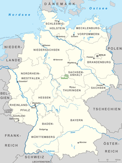
Saxony-Anhalt is a state of Germany, bordering the states of Brandenburg, Saxony, Thuringia and Lower Saxony. It covers an area of 20,447.7 square kilometres (7,894.9 sq mi) and has a population of 2.19 million inhabitants, making it the 8th-largest state in Germany by area and the 11th-largest by population. Its capital is Magdeburg and its largest city is Halle (Saale).

The Saale, also known as the Saxon Saale and Thuringian Saale, is a river in Germany and a left-bank tributary of the Elbe. It is not to be confused with the smaller Franconian Saale, a right-bank tributary of the Main, or the Saale in Lower Saxony, a tributary of the Leine.
Altenburger Land is a district in Thuringia, Germany. It is bounded by the district of Greiz, the Burgenlandkreis (Saxony-Anhalt), and the districts Leipzig, Mittelsachsen and Zwickau in Saxony. The district is a member of the Central German Metropolitan Region.
The Goldene Aue is a valley in eastern Germany, in the states Thuringia and Saxony-Anhalt. It is situated between the towns Nordhausen in the west, and Sangerhausen in the east. It is bordered by the mountain ranges Harz in the north, and Windleite and Kyffhäuser in the south. The river Helme flows through the Goldene Aue.

Benneckenstein is a town in the district of Harz, in Saxony-Anhalt, Germany. Since 1 January 2010, it has been part of the town of Oberharz am Brocken. Benneckenstein is in the eastern Harz, 14 km southeast of Braunlage, and 24 km south of Wernigerode.

The Aland is a river in the German states of Lower Saxony and Saxony-Anhalt, left tributary of the Elbe. It is the continuation of the river Biese, which is the continuation of the river Milde. The Aland is 27 kilometres (17 mi) long, whereas the total Milde-Biese-Aland system is 97 kilometres (60 mi) long. The Aland flows into the Elbe in Schnackenburg.
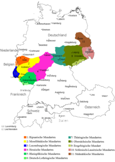
Thuringian is an East Central German dialect group spoken in much of the modern German Free State of Thuringia north of the Rennsteig ridge, southwestern Saxony-Anhalt and adjacent territories of Hesse and Bavaria. It is close to Upper Saxon spoken mainly in the state of Saxony, therefore both are also regarded as one Thuringian-Upper Saxon dialect group. Thuringian dialects are among the Central German dialects with the highest number of speakers.

The Helme is river in central Germany that is about 65 kilometres (40 mi) long and which forms a left-hand, western tributary of the Unstrut in the states of Thuringia and Saxony-Anhalt.

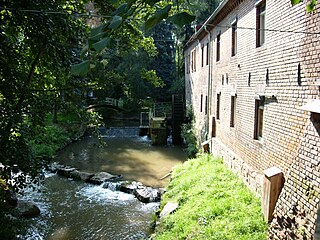
The Rappbode is a right-hand, southwestern tributary of the River Bode in the Harz mountains in the German state of Saxony-Anhalt. In its lower reaches it is impounded by the Rappbode Dam, the largest dam in the Harz.

The Evangelical Church in Central Germany is a United church body covering most of the German states of Saxony-Anhalt and Thuringia and some adjacent areas in Brandenburg and Saxony.

Neue Luppe is an artificial river of Saxony and Saxony-Anhalt, Germany.

The Schnauder is a river of Saxony, Saxony-Anhalt and Thuringia in Germany. It is a right tributary of the White Elster, which it joins near Groitzsch.
Alte Elbe is the German name for oxbows of the Elbe, i.e. cut-off meanders. With about 20 km (12 mi) the largest one of these is the Dornburger Alte Elbe, a river of Saxony-Anhalt, Germany.

Lossa is a river of Saxony-Anhalt and Thuringia, Germany. It flows into the Unstrut in Leubingen.
The Wethau is a river which springs from Hohendorf, Saale-Holzland-Kreis and runs through Thuringia and Saxony-Anhalt. It flows into the River Saale at Schönburg (Saale), Burgenlandkreis. The River Wethau falls 229.9 metres (754 ft) and is 30 kilometres (19 mi) long.
The South Harz Nature Park is located in the county of Nordhausen in north Thuringia, Germany. The act designating this nature park in the Harz Mountains came into force on 31 December 2010 and thus founded the fifth nature park in Thuringia. It has an area of 267 km². The park is managed by the South Harz Tourist Association in conjunction with the Kyffhäuser Nature Park.
Dammbach is a community of Lower Franconia in Bavaria, Germany.
The Milde is a river in the German state of Saxony-Anhalt, source river of the Biese. It is 36 kilometres (22 mi) long, whereas the total Milde-Biese-Aland system is 97 kilometres (60 mi) long. The Milde flows into the Biese near Meßdorf.

Ichte, in its upper course also called Steinaer Bach, is a river of Thuringia and Lower Saxony, Germany.