
Lancaster County, sometimes nicknamed the Garden Spot of America or Pennsylvania Dutch Country, is a county in the Commonwealth of Pennsylvania, United States. As of the 2020 census, the population was 552,984, making it Pennsylvania's sixth-most populous county. Its county seat is also Lancaster. Lancaster County comprises the Lancaster metropolitan statistical area. The county is part of the South Central region of the state.

The Kauffman's Distillery Covered Bridge or Sporting Hill Bridge is a covered bridge that spans Chiques Creek in Lancaster County, Pennsylvania, United States. A county-owned and maintained bridge, its official designation is the Big Chiques #1 Bridge.

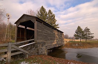
The Lime Valley Covered Bridge or Strasburg Bridge is a covered bridge that spans Pequea Creek in Lancaster County, Pennsylvania, United States. A county-owned and maintained bridge, its official designation is the Pequea #8 Bridge.

The Willow Hill Covered Bridge is a covered bridge located off U.S. Route 30 that spans Miller’s Run in Lancaster County, Pennsylvania, United States. It was built in 1962 by Roy Zimmerman as a reconstruction using parts of the Miller's Farm Covered Bridge, built in 1871 by Elias McMellen, and Good's Fording Covered Bridge, built in 1855. It crosses Miller's Run and is 93 feet (28 m) long and 15 feet (4.6 m) wide.

Rapho Township is a township that is located in northwestern Lancaster County, Pennsylvania, United States. The population was 12,058 at the time of the 2020 census.
Warwick Township is a township in north-central Lancaster County, Pennsylvania, United States. The population was 19,068 at the 2020 census. It completely surrounds the borough of Lititz and contains the unincorporated villages of Brunnerville, Disston, Kissel Hill, Lexington, Millway, and Rothsville.

West Lampeter Township is a township that is located in central Lancaster County, Pennsylvania, United States. The population was 17,365 at the time of the 2020 census.

Radnor Township, often called simply Radnor, is a first class township with home rule status in Delaware County, Pennsylvania, United States.

U.S. Route 222 is a U.S. Highway that is a spur of US 22 in the states of Maryland and Pennsylvania. It runs for 95 miles (153 km) from US 1 in Conowingo, Maryland, north to the junction of Interstate 78 (I-78) and Pennsylvania Route 309 in Dorneyville, Pennsylvania. US 222 is almost entirely in Pennsylvania, and serves as the state's principal artery between the Lancaster and Reading areas in the west and the Lehigh Valley in the east.

This is a list of properties and districts listed on the National Register of Historic Places in Pennsylvania. As of 2015, there are over 3,000 listed sites in Pennsylvania. All 67 counties in Pennsylvania have listings on the National Register.

Pennsylvania Route 72 is a 37.8-mile-long (60.8 km) north–south state route located in southeast Pennsylvania. The southern terminus of the route is at U.S. Route 222 /PA 272 in Lancaster. The northern terminus is at PA 443 north of Lickdale in Union Township. PA 72 serves as a major road connecting Lancaster and Lebanon counties, serving East Petersburg, Manheim, Cornwall, Lebanon, and Jonestown. The route intersects several major roads including US 30 and PA 283 north of Lancaster, the Pennsylvania Turnpike south of Cornwall, US 322 along a concurrency on a freeway bypassing Cornwall, US 422 in Lebanon, US 22 near Jonestown, and I-81 via Fisher Avenue in Lickdale.
The Buck Hill Covered Bridge, Eichelberger's Covered Bridge, or Abram Hess' Mill Bridge is a burr arch-truss style covered bridge located in Lancaster County, Pennsylvania, United States. It is located on the Buck Hill Farm's pond on private property.
The Miller's Farm Covered Bridge was a covered bridge constructed by Elias McMellen in 1871. The bridge was located in Lancaster County, Pennsylvania. In 1962, the bridge's remaining parts along with timbers from Daniel Good's Fording Covered Bridge were used in the construction of the Willow Hill Covered Bridge.
The Bellbank Covered Bridge was a covered bridge that spanned the Octoraro Creek on the border between Colerain Township, Lancaster County and Upper Oxford Township, Chester County in Pennsylvania. The 112 ft bridge was located on Street Road near Pennsylvania Route 472. It was burnt and destroyed by an arsonist on March 19, 1979. The covered bridge was also referred to as Bridge #11 by Chester County before it was replaced with the current steel beam bridge.

Pennsylvania Route 372 is an east–west highway in York, Lancaster, and Chester counties in the U.S. state of Pennsylvania. Its western terminus is at PA 74 in Lower Chanceford Township north of Delta and west of Holtwood, and its eastern terminus is at PA 82 in Coatesville. PA 372 heads east from PA 74 in York County and crosses the Susquehanna River on the Norman Wood Bridge. The route continues through Lancaster County, intersecting PA 272 in Buck, U.S. Route 222 and PA 472 in Quarryville, and PA 896 in Georgetown. PA 372 crosses into Chester County and intersects PA 41 in Atglen and PA 10 in Parkesburg before continuing to Coatesville. PA 372 is a two-lane undivided road throughout its length.
Willow Hill may refer to:

Pennsylvania Route 272 is a 54.7-mile-long (88.0 km) highway in southeastern Pennsylvania, in the Lancaster area. The southern terminus of the route is at the Mason–Dixon line southeast of Nottingham, where the road continues into Maryland as Maryland Route 272. The northern terminus is at an interchange with U.S. Route 222 and PA 568 near Adamstown, where PA 568 continues east. The route heads from the Maryland border northwest through the southwestern corner of Chester County, intersecting US 1 in Nottingham. PA 272 continues west into Lancaster County and intersects US 222 in Wakefield, where it turns north and passes through Buck before widening into a divided highway as it comes to another junction with US 222 in Willow Street. Here, the route becomes unsigned and follows US 222 north through Lancaster along a one-way pair of city streets. North of Lancaster, US 222 splits at an interchange with US 30 and PA 272 becomes signed again, heading northeast parallel to the freeway alignment of US 222 and passing through Akron, Ephrata, and Adamstown. The route enters Berks County and comes to its northern terminus.

Pennsylvania Route 741 is a 26.3-mile-long (42.3 km) state highway that runs through western and southern Lancaster County in the U.S. state of Pennsylvania. The western terminus is along Rohrerstown Road north of an intersection with Commercial Avenue near East Petersburg. The eastern terminus is at PA 41 in Gap. PA 741 heads south from East Petersburg and runs through the western suburbs of Lancaster. The route turns southeast and passes through Millersville before it turns east at New Danville. PA 741 forms a concurrency with U.S. Route 222 between Willow Street and Lampeter before it continues east through farmland in the Pennsylvania Dutch Country that is home to several Amish families, passing through Strasburg before reaching Gap.

The 97th Pennsylvania House of Representatives District is located in Lancaster County. Steven Mentzer has represented the 97th district in the Pennsylvania House of Representatives since 2013.
