The Avioane Craiova IAR-93 Vultur (Vulture) is a twinjet, subsonic, close support, ground attack and tactical reconnaissance aircraft with secondary capability as low level interceptor. Built as single-seat main attack version or combat capable two-seat version for advanced flying and weapon training, it was developed as a joint Yugoslav-Romanian project in the 1970s for the air forces of both nations. The Romanian aircraft were built by I.R.Av. Craiova as IAR-93, and its Yugoslav counterpart by Soko as the Soko J-22 Orao. For Romania, the IAR-93 was intended to replace MiG-15s and MiG-17s in the fighter-bomber role.

Segarcea is a small town in Dolj County, Romania, about 25 kilometres from Craiova, the county seat. It has 8,000 inhabitants and it is famous for its white wines.

Ion Oblemenco Stadium was a multi-purpose stadium in Craiova, Romania. It was used mostly for football matches and was the home ground of Universitatea Craiova. The stadium used to hold up to 25,252 people before it was demolished.
The University of Medicine and Pharmacy of Craiova is a tertiary educational institution in the city of Craiova, in south-western Romania.
The Al-Fanar Hotel is a hotel in Baghdad, Iraq. It is popular with independent travelers to the city. It is also the place where the Iraqi Heavy Metal band Acrassicauda played their last concert inside Iraq.

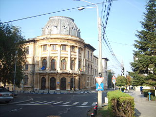
The Carol I National College is a high school located in central Craiova, Romania, on Ioan Maiorescu Street. It is one of the most prestigious secondary education institutions in Romania. Between 1947 and 1997 it operated under the name of Nicolae Bălcescu High School.
The canton of Laragne-Montéglin is an administrative division in southeastern France. At the French canton reorganisation which came into effect in March 2015, the canton was expanded from 7 to 13 communes :

Kułakowice Trzecie is a village in the administrative district of Gmina Hrubieszów, within Hrubieszów County, Lublin Voivodeship, in eastern Poland, close to the border with Ukraine. It lies approximately 13 kilometres (8 mi) north-west of Hrubieszów and 94 km (58 mi) south-east of the regional capital Lublin.

Fangyuan Township is a rural township in Changhua County, Taiwan.

Pałki is a village in the administrative district of Gmina Zadzim, within Poddębice County, Łódź Voivodeship, in central Poland.In Pałki is big wood & "Lutowie" sea.Pałki territory is a 859 ha. two position in Gmina Zadzim It lies approximately 3 kilometres (2 mi) north-west of Zadzim, 15 km (9 mi) south-west of Poddębice, and 44 km (27 mi) west of the regional capital Łódź.

Belno is a village in the administrative district of Gmina Gostynin, within Gostynin County, Masovian Voivodeship, in east-central Poland. It lies approximately 11 kilometres (7 mi) west of Gostynin and 117 km (73 mi) west of Warsaw.
Ostaszewo-Włuski is a village in the administrative district of Gmina Gzy, within Pułtusk County, Masovian Voivodeship, in east-central Poland.

CFR Stadium is a multi-use stadium in Craiova. It was the home ground of Gaz Metan CFR Craiova and has 3,000 seats.

Glinka is a village in the administrative district of Gmina Braniewo, within Braniewo County, Warmian-Masurian Voivodeship, in northern Poland, close to the border with the Kaliningrad Oblast of Russia. It lies approximately 5 kilometres (3 mi) south-west of Braniewo and 78 km (48 mi) north-west of the regional capital Olsztyn.

Józefowo is a village in the administrative district of Gmina Braniewo, within Braniewo County, Warmian-Masurian Voivodeship, in northern Poland, close to the border with the Kaliningrad Oblast of Russia. It lies approximately 5 kilometres (3 mi) south-west of Braniewo and 78 km (48 mi) north-west of the regional capital Olsztyn.

Osetne Pole is a settlement in the administrative district of Gmina Stare Czarnowo, within Gryfino County, West Pomeranian Voivodeship, in north-western Poland. It lies approximately 9 kilometres (6 mi) north-west of Stare Czarnowo, 14 km (9 mi) north-east of Gryfino, and 13 km (8 mi) south-east of the regional capital Szczecin.
Vitkovići is a village in the municipality of Bratunac, Bosnia and Herzegovina.

Veliko Laole is a village situated in Petrovac na Mlavi municipality in Serbia.

Polyvalent Hall from Craiova is a multi-purpose indoor arena in Craiova, Romania. It has a seating capacity of 4,215 spectators.


