Related Research Articles
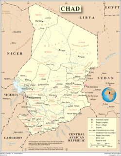
Chad is one of the 47 landlocked countries in the world and is located in North Central Africa, measuring 1,284,000 square kilometers (495,755 sq mi), nearly twice the size of France and slightly more than three times the size of California. Most of its ethnically and linguistically diverse population lives in the south, with densities ranging from 54 persons per square kilometer in the Logone River basin to 0.1 persons in the northern B.E.T. (Borkou-Ennedi-Tibesti) desert region, which itself is larger than France. The capital city of N'Djaména, situated at the confluence of the Chari and Logone Rivers, is cosmopolitan in nature, with a current population in excess of 700,000 people.
Mali is located in Africa. The history of the territory of modern Mali may be divided into:
Niger or the Niger, officially the Republic of the Niger, is a landlocked country in West Africa named after the Niger River. Niger is a unitary state bordered by Libya to the northeast, Chad to the east, Nigeria to the south, Benin and Burkina Faso to the southwest, Mali to the west, and Algeria to the northwest. Niger covers a land area of almost 1,270,000 km2 (490,000 sq mi), making it the second-largest landlocked country in West Africa, after Chad. Over 80% of its land area lies in the Sahara Desert. The country's predominantly Muslim population of about 22 million live mostly in clusters in the far south and west of the country. The capital and largest city is Niamey, located in Niger's southwest corner.

Nigeria, officially the Federal Republic of Nigeria, is a country in West Africa. It is geographically situated between the Sahel to the north and the Gulf of Guinea to the south in the Atlantic Ocean. It covers an area of 923,769 square kilometres (356,669 sq mi), and with a population of over 216 million, It is the most populous country in Africa, and the world’s seventh-most populous country. Nigeria borders Niger in the north, Chad in the northeast, Cameroon in the east, and Benin in the west. Nigeria is a federal republic comprising 36 states and the Federal Capital Territory, where the capital, Abuja, is located. The largest city in Nigeria is Lagos, one of the largest metropolitan areas in the world and the second-largest in Africa.

Nigeria is a country in West Africa. Nigeria shares land borders with the Republic of Benin in the west, Chad and Cameroon in the east, and Niger in the north. Its coast lies on the Gulf of Guinea in the south and it borders Lake Chad to the northeast. Noted geographical features in Nigeria include the Adamawa Plateau, Mambilla Plateau, Jos Plateau, Obudu Plateau, the Niger River, Benue River, and Niger Delta.

Mali is a landlocked nation in West Africa, located southwest of Algeria, extending south-west from the southern Sahara Desert through the Sahel to the Sudanian savanna zone. Mali's size is 1,240,192 square kilometers.
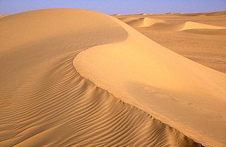
The Ténéré is a desert region in the south central Sahara. It comprises a vast plain of sand stretching from northeastern Niger into western Chad, occupying an area of over 400,000 square kilometres (150,000 sq mi). The Ténéré's boundaries are said to be the Aïr Mountains in the west, the Hoggar Mountains in the north, the Djado Plateau in the northeast, the Tibesti Mountains in the east, and the basin of Lake Chad in the south. The central part of the desert, the Erg du Bilma, is centred at approximately 17°35′N10°55′E. It is the locus of the Neolithic Tenerian culture.

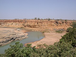
The Djado Plateau lies in the Sahara, in northeastern Niger. It is known for its cave art, but is now largely uninhabited, with abandoned towns and forts still standing and visible. As of 2011, the commune of Djado had a total population of 1,495 people.

Agadez Region is one of the seven regions of Niger. At 667,799 square kilometres (257,839 sq mi), it covers more than half of Niger's land area, and is the largest region in the country, as well as the largest African state subdivision. The capital of the department is Agadez.
The United States Africa Command, is one of the eleven unified combatant commands of the United States Department of Defense, headquartered at Kelley Barracks, Stuttgart, Germany. It is responsible for U.S. military operations, including fighting regional conflicts and maintaining military relations with 53 African nations. Its area of responsibility covers all of Africa except Egypt, which is within the area of responsibility of the United States Central Command. U.S. AFRICOM headquarters operating budget was $276 million in fiscal year 2012.
The following outline is provided as an overview of and topical guide to Niger:

The mineral mining industry is a crucial piece of the Economy of Niger. Exports of minerals consistently account for 40% of exports.
Boko Haram, officially known as Jamā'at Ahl as-Sunnah lid-Da'wah wa'l-Jihād, is an Islamic terrorist organization based in northeastern Nigeria, which is also active in Chad, Niger, and northern Cameroon. In 2016, the group split, resulting in the emergence of a hostile faction known as the Islamic State's West Africa Province.

Operation Barkhane is an ongoing anti-insurgent operation that started on 1 August 2014, and is led by the French military against Islamist groups in Africa's Sahel region. It consists of a roughly 5,000-strong French force, which is permanently headquartered in N’Djamena, the capital of Chad. The operation is led in co-operation with five countries, all of which are former French colonies that span the Sahel: Burkina Faso, Chad, Mali, Mauritania and Niger. The countries are collectively referred to as the "G5 Sahel". The operation is named after a crescent-shaped dune in the Sahara desert.
Ounjougou is the name of a lieu-dit found in the middle of an important complex of archaeological sites in the Upper Yamé Valley on the Bandiagara Plateau, in Dogon Country, Mali. The Ounjougou archaeological complex consists of over a hundred sites. The analysis of many layers rich in archaeological and botanical remains has enabled establishment of a major chronological, cultural and environmental sequence crucial to understand settlement patterns in the Inland Niger Delta and West Africa. Ounjougou has yielded the earliest pottery found in Africa, and is believed to be one of the earliest regions in which the independent development of pottery occurred.

The Lost Tree, also known as the Arbre Thierry Sabine, is an isolated relic tree in the Ténéré region of the Sahara desert in northeast Niger.

The Tongo Tongo ambush or the Niger ambush occurred on 4 October 2017, when armed militants from the Islamic State in the Greater Sahara (ISGS) attacked Nigerien and US soldiers outside the village of Tongo Tongo, Niger, while they were returning to base after a stop in the village. During the ambush, four Nigeriens, four US soldiers, and at least 21 ISGS militants were killed, and eight Nigeriens and two US soldiers including the team commander were wounded. In the day preceding the ambush, the Nigerien and US soldiers conducted a mission attempting to locate and capture or kill Doundou Chefou, a commander in the ISGS.

Sadou Soloké is the Governor of the Agadez Region, Niger.
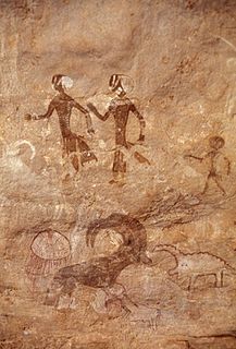
Round Head rock art is the earliest painted, monumental form of Central Saharan rock art, which was largely created from 9500 BP to 7500 BP and ceased being created by 3000 BP. The Round Head Period is preceded by the Kel Essuf Period and followed by the Pastoral Period. Round Head rock art number up to several thousand depictions in the Central Sahara. Human and untamed animal artforms are usually portrayed, with a variety of details, in painted Round Head rock art. Painted Round Head rock art and engraved Kel Essuf rock art usually share the same region and occasionally the same rockshelters. The Round Head rock art of Tassili and the surrounding mountainous areas bear considerable similarity with traditional Sub-Saharan African cultures.
Kel Essuf rock art is the earliest form of engraved anthropomorphic Central Saharan rock art, which was produced prior to 9800 BP. The Kel Essuf Period is preceded by the Bubaline Period and followed by the Round Head Period. Kel Essuf rock art usually depicts oval-shaped artforms, which possess four short appendages – two upper appendages, or arms, that may have between three to four finger-like digits, and two lower appendages, or legs – as well as an additional appendage, or penile appendage, without finger-like digits, which may be indicative of maleness. The Kel Essuf rock art tradition of engraving may have developed into the monumental Round Head rock art tradition of painting. Round Head rock art bears considerable similarity with traditional Sub-Saharan African cultures.
References
- 1 2 3 McCormick, Ty (October 4, 2017). "Highway Through Hell". Foreign Policy. Archived from the original on October 5, 2017.
- ↑ Taub, Ben (April 10, 2017). "The Desperate Journey of a Trafficked Girl". The New Yorker . Retrieved October 4, 2017.
Oumar’s convoy evaded the military for four days and several hundred miles, but the checkpoint at Dao Timmi, situated at a gap between mountains in the Djado Plateau region, is unavoidable.
- ↑ African Studies Association (1992). The Arts of Africa: an annotated bibliography. African Studies Association. p. 52.
| General | |
|---|---|
| Other | |
Coordinates: 20°32′N13°33′E / 20.533°N 13.550°E
| | This Niger location article is a stub. You can help Wikipedia by expanding it. |