
Thimphu is the capital and largest city of Bhutan. It is situated in the western central part of Bhutan, and the surrounding valley is one of Bhutan's dzongkhags, the Thimphu District. The ancient capital city of Punakha was replaced by Thimphu as capital in 1955, and in 1961 Thimphu was declared as the capital of the Kingdom of Bhutan by the 3rd Druk Gyalpo Jigme Dorji Wangchuck.
Transport in Bhutan uses about 8,000 kilometres (5,000 mi) of roads and four airports, three of which are operational and interconnected. Paro Airport is the only airport which accommodates international flights. As part of Bhutan's infrastructure modernization programs, its road system has been under development since the 1960s. There are no railways, and as Bhutan is a landlocked country with no major waterways, there are no ports.

The Kingdom of Bhutan is divided into 20 districts. Bhutan is located between the Tibet Autonomous Region of China and India on the eastern slopes of the Himalayas in South Asia.

Bhutan, officially the Kingdom of Bhutan, is a landlocked South Asian country, which is situated in the Eastern Himalayas, between China in the north and India in the south. A mountainous country, Bhutan is known locally as "Druk Yul" or "Land of the Thunder Dragon", a name reflecting the cultural heritage of the country. The exonym Bhutan likely derives from the Prakrit hybrid word Bhŏṭṭaṃta, a name referring to its geographical proximity to Tibet (Bhŏṭṭa). Nepal and Bangladesh are located near Bhutan but do not share a border with it. The country has a population of over 727,145 and territory of 38,394 square kilometres (14,824 sq mi) and ranks 133rd in land area and 160th in population. Bhutan is a constitutional monarchy with a king as the head of state and a prime minister as the head of government. Vajrayana Buddhism is the state religion and the Je Khenpo is the head of state religion.

A gewog, in the past also spelled as geog, is a group of villages in Bhutan. The head of a gewog is called a gup. Gewogs form a geographic administrative unit below dzongkhag districts, and above Dzongkhag Thromde class B and Yenlag Thromde municipalities. Dzongkhag Thromde class A municipalities have their own independent local government body.
A dungkhag is a sub-district of a dzongkhag (district) of Bhutan. The head of a dungkhag is a Dungpa. As of 2007, nine of the twenty dzongkhags had from one to three dungkhags, with sixteen dungkhags in total.
Phuntsholing, also spelled as Phuentsholing, is a border town in southern Bhutan and is the administrative seat of Chukha District. The town occupies parts of both Phuentsholing Gewog and Sampheling Gewog.

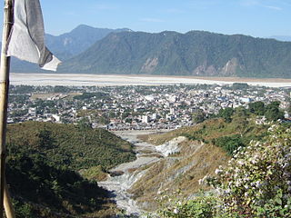
Jaigaon is a census town in Alipurduar subdivision under Kalchini Block of Alipurduar district in the state of West Bengal, India. It is located on the country's border with Bhutan, and Bhutan Gate separates the two countries. Phuentsholing is the Bhutan's nearest city to Jaigaon. Bhutan does not have domestic roads linking to all its towns, so uses roads passing through Jaigaon to reach such destinations as Samtse, Gomtu, Nganglam and Samdrup Jongkhar.
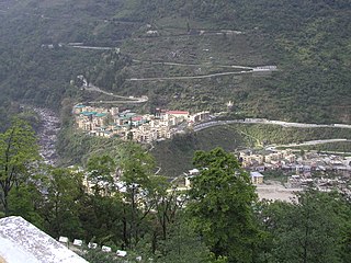
Mebisa, formerly called Chukha or Chhukha, is a town on the Wangchu River and seat of the Chukha District in Bhutan. In 2005, it had a population of 2,855.
Bhutan is a Buddhist country by constitution and Buddhism plays a vital role in the country.

Kanglung is a town in eastern Bhutan. It is located in Trashigang District and is the location of Sherubtse College, one of the Royal University of Bhutan's academic institutes.
Gyalpozhing or Gyelpozhing is a town in Mongar District in southeastern-central Bhutan. It is located to the west of Mongar and east of Lingmethang.
Daga , also officially referred to as Dagana, is a town in Goshi Gewog, Dagana District in southwestern Bhutan. It is the administrative capital, Dzongkhag Thromde, of the district.
Gasa is a town near Gasa Dzong in Gasa District in northwestern Bhutan.

Dramitse is a town in Drametse Gewog in the east part of Mongar District, Eastern Bhutan. At the 2005 census, its population was 541. It is situated on a hill opposite the town of Trashigang.

Gomtu is a border town in south-western Bhutan near the border with India. It is located in Samtse District. Gomtu is a small industrial town by road only reachable via India. It lays at a distance of some 70 kilometers west of the large Bhutanese border town of Phuentsholing. There are two cement factories based on the Gomtu Industrial Estate, Penden Cement and Lhaki cement. Gomtu has a government Higher Secondary School and a government referral hospital. In the Pugli Hills around Gomtu the mineral dolomite is mined by the Jigme Mining Corporation Limited.
Nganglam or Nanglam is a town in south-eastern Bhutan. It is located in Pema Gatshel District.
Sergithang Gewog is one of the twelve gewogs of Tsirang District, Bhutan. Sergithang Gewog is located in the northwest of Tsirang District, east of the River Puna Tsang Chu, north of its tributary Burichu, west of Pungtencchu Gewog and south of Wangdue Phodrang District.


