
The Tocantins River is a river in Brazil, the central fluvial artery of the country. In the Tupi language, its name means "toucan's beak". It runs from south to north for about 2,450 km (1,520 mi). While sometimes included in definitions of the Amazon basin, the Tocantins is not a branch of the Amazon River, since its waters flow into the Atlantic Ocean via an eastern channel of the Amazon Delta, alongside those of the Amazon proper. It flows through four Brazilian states and gives its name to one of Brazil's newest states, formed in 1988 from what was until then the northern portion of Goiás.

Portuguese colonization of the Americas constituted territories in the Americas belonging to the Kingdom of Portugal. Portugal was the leading country in the European exploration of the world in the 15th century. The Treaty of Tordesillas in 1494 divided the Earth outside Europe into Castilian and Portuguese global territorial hemispheres for exclusive conquest and colonization. Portugal colonized parts of South America, but also made some unsuccessful attempts to colonize North America.

The federative units of Brazil are subnational entities with a certain degree of autonomy and endowed with their own government and constitution, which together form the Federative Republic of Brazil. There are 26 states and one federal district. The states are generally based on historical, conventional borders which have developed over time. The states are divided into municipalities, while the Federal District assumes the competences of both a state and a municipality.

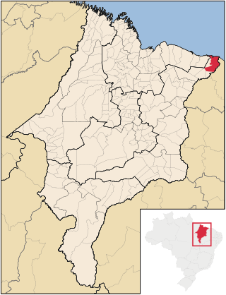
Maranhão is a state in Brazil. Located in the country's Northeast Region, it has a population of about 7 million and an area of 332,000 km2 (128,000 sq mi). Clockwise from north, it borders on the Atlantic Ocean for 2,243 km and the states of Piauí, Tocantins and Pará. The people of Maranhão have a distinctive accent within the common Northeastern Brazilian dialect. Maranhão is described in literary works such as Exile Song by Gonçalves Dias and Casa de Pensão by Aluísio Azevedo.

Piauí is one of the states of Brazil, located in the country's Northeast Region. The state has 1.6% of the Brazilian population and produces 0.7% of the Brazilian GDP.

São Luís is the capital and largest city of the Brazilian state of Maranhão. The city is located on Upaon-açu Island or Ilha de São Luís, in the Baía de São Marcos, an extension of the Atlantic Ocean which forms the estuary of Pindaré, Mearim, Itapecuru and other rivers. Its coordinates are 2.53° south, 44.30° west. São Luís has the second largest maritime extension within Brazilian states. Its maritime extension is 640 km. The city proper has a population of some 1,037,775 people. The metropolitan area totals 1,536,017, ranked as the 15th largest in Brazil.

The Captaincies of Brazil were captaincies of the Portuguese Empire, administrative divisions and hereditary fiefs of Portugal in the colony of Terra de Santa Cruz, later called Brazil, on the Atlantic coast of northeastern South America. Each was granted to a single donee, a Portuguese nobleman who was given the title captain General.

The Treaty of Madrid was an agreement concluded between Spain and Portugal on 13 January 1750. In an effort to end decades of conflict in the region of present-day Uruguay, the treaty established detailed territorial boundaries between Portuguese Brazil and the Spanish colonial territories to the south and west. Portugal also recognized Spain's claim to the Philippines while Spain acceded to the westward expansion of Brazil. The treaty included a mutual guarantee of support in case either state's American colonies were attacked by a third power.
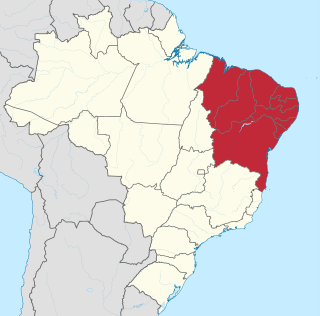
The Northeast Region of Brazil is one of the five official and political regions of the country according to the Brazilian Institute of Geography and Statistics. Of Brazil's twenty-six states, it comprises nine: Maranhão, Piauí, Ceará, Rio Grande do Norte, Paraíba, Pernambuco, Alagoas, Sergipe and Bahia, along with the Fernando de Noronha archipelago.

Pedro Teixeira, occasionally referred to as the Conqueror of the Amazon, was a Portuguese conquistador and military officer, who became, in 1637, the first European to travel up and down the entire length of the Amazon River, he also headed the government of the captaincy of Pará in two different periods, one in 1620-1621 and another in 1640–1641.
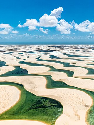
Lençóis Maranhenses National Park is a national park in Maranhão state in northeastern Brazil, just east of the Baía de São José. Protected on June 2, 1981, the 155,000 ha (380,000-acre) park includes 70 km (43 mi) of coastline, and an interior composed of rolling sand dunes. During the rainy season, the valleys among the dunes fill with freshwater lagoons, prevented from draining by the impermeable rock beneath. The park is home to a range of species, including four listed as endangered, and has become a popular destination for ecotourists.

Codó is a city in the Maranhão, Brazil. It has an estimated population of 123,116 (2020) and an area of 4,361.344 km2. Therefore, the sixth most populous municipality in the state. It has the largest concentration of religious centers of African origin in Brazil, with 400 terreiros.

Timon is a Brazilian municipality in the State of Maranhão. The population is 170,222 and the total area is 1765 km2.
The Maranhão Babaçu forests is a tropical moist broadleaf forest ecoregion of north-central Brazil. The forests form a transition between the equatorial forests of the Amazon biome to the west and the drier savannas and xeric shrublands to the south and east.

The Mearim River is a river in Maranhão state of northern Brazil. The river originates in the southern part of Maranhão, and drains north into the Baía de São Marcos, an estuary that also receives the Pindaré and Grajaú rivers, which are sometimes considered tributaries of the Mearim. The lower Mearim is known for its pororoca, or tidal bore.

Tambor de Mina is an Afro-Brazilian religious tradition, practiced mainly in the Brazilian states of Maranhão, Piauí, Pará and the Amazon rainforest.
Araioses is the easternmost city in the Brazilian state of Maranhão. It lies near the Parnaíba River's delta, and its territory also include the Canárias, Desgraça, Coroatá and Grande de Paulino islands, apart from several smaller islands.

Axixá is a municipality in the state of Maranhão in the Northeast region of Brazil. The main town lies on the left bank of the Munim River, upstream from Icatu.
Gamelaa.k.a.Curinsi or Acobu, is an unclassified and presumably extinct language of the Maranhão region of Northeastern Brazil. It was originally spoken along the Itapecuru River, Turiaçu River, and Pindaré River, with ethnic descendants reported to be living in Cabo and Vianna in Maranhão State.

The State of Maranhão was the northern of two 17–18th century administrative divisions of the colonial Portuguese Empire in South America.
