Dasht, Armenia

Last updated

Coordinates: 40°13′41″N44°18′04″E / 40.22806°N 44.30111°E / 40.22806; 44.30111

Geographic coordinate system Coordinate system

A geographic coordinate system is a coordinate system that enables every location on Earth to be specified by a set of numbers, letters or symbols. The coordinates are often chosen such that one of the numbers represents a vertical position and two or three of the numbers represent a horizontal position; alternatively, a geographic position may be expressed in a combined three-dimensional Cartesian vector. A common choice of coordinates is latitude, longitude and elevation. To specify a location on a plane requires a map projection.

Dasht
Դաշտ
Armenia adm location map.svg
Red pog.svg
Dasht
Coordinates: 40°13′41″N44°18′04″E / 40.22806°N 44.30111°E / 40.22806; 44.30111
Country Armenia
Marz (Province) Armavir
Founded 1926
Population (2001)
  Total 723
Time zone   (UTC+4)
  Summer (DST)  (UTC+5)

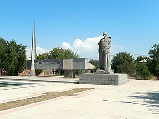
Dasht (Armenian : Դաշտ, meaning "field") is a town in the Armavir Province of Armenia. Just outside the town is a 1st millennium BCE fortress.

Armenian language Indo-European language

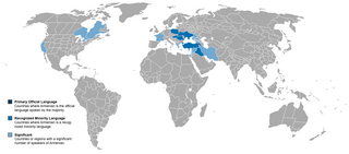
The Armenian language is an Indo-European language spoken primarily by Armenians. It is the official language of Armenia. Historically being spoken throughout the Armenian Highlands, today, Armenian is widely spoken throughout the Armenian diaspora. Armenian is written in its own writing system, the Armenian alphabet, introduced in 405 AD by Mesrop Mashtots.

1st millennium BC millennium

The 1st millennium BC is the period of time between from the year 1000 BC to 1 BC . It encompasses the Iron Age in the Old World and sees the transition from the Ancient Near East to Classical Antiquity.

See also

Related Research Articles

Arevik Place in Armavir, Armenia

Arevik is a town in the Armavir province of Armenia. The name Arevik comes from the root Arev meaning "sun".

Khoronk Place in Armavir, Armenia

Khoronk is a town in the Armavir province of Armenia. The town's church dates to 1880.

Norakert Place in Armavir, Armenia

Norakert is a town in the Armavir Province of Armenia.

Norapat Place in Armavir, Armenia

Norapat is a former town in the Armavir Province of Armenia. The town is now part of Armavir.

Pshatavan Place in Armavir, Armenia

Pshatavan ; formerly, Igdalu and Igdali) is a town in the Armavir Province of Armenia.

Apaga, Armenia Place in Armavir, Armenia

Apaga is a town in the Armavir Province of Armenia.

Araks, Vagharshapat Place in Armavir, Armenia

Araks, known as Nerkin Karkhun and Sharifabad until 1946, is a village in the eastern part of the Armavir Province of Armenia.

Arazap Place in Armavir, Armenia

Arazap is a town in the Armavir Province of Armenia.

Aygeshat, Armavir Place in Armavir, Armenia

Aygeshat, known as Ghuzigidan until 1950, is a village in the Armavir Province of Armenia.

Griboyedov, Armenia Place in Armavir, Armenia

Griboyedov is a town in the Armavir Province of Armenia. The town is named in honor of Russian writer and diplomat Alexandr Griboyedov.

Hovtamej Place in Armavir, Armenia

Hovtamej is a town in the Armavir Province of Armenia. The town's church dates from the 19th century.

Jrarat, Armavir Place in Armavir, Armenia

Jrarat formerly known as Gharkhun or Verin Gharkhun, is a village in the Armavir Province of Armenia. It has a large poultry industry and nearby is a piece of land reserved for the cochineal dye beetles, Porphyrophora hamelii.

Lusagyugh, Armavir Place in Armavir, Armenia

Lusagyugh is a town in the Armavir Province of Armenia.

Margara Place in Armavir, Armenia

Margara is a town in the Armavir Province of Armenia. Margara is the closest border crossing to Turkey from Yerevan. Margara has a road bridge across the Arax River to Turkey. The Border Guard Service of Russia patrols the closed border between Armenia and Turkey.

Mrgastan Place in Armavir, Armenia

Mrgastan is a village in the Armavir Province of Armenia. The town's church, dedicated to Saint Hovhannes, was built in 1912.

Musaler Place in Armavir, Armenia

Musaler is a village in the Armavir Province of Armenia. The town was renamed in 1972 after Musa Ler, the site of Armenian resistance in 1915.

Alashkert, Armenia Place in Armavir, Armenia

Alashkert ; known as Kyarimarkh until 1935, is a village in the Armavir Province of Armenia. It was known as Sovetakan between 1935 and 2008. In 2008, the village was renamed Alashkert, after the historic Western Armenian town of Alashkert.

Tsaghkunk, Armavir Place in Armavir, Armenia

Tsaghkunk is a town in the Armavir Province of Armenia. The town's church dates from the 19th century.

Haykavan, Armavir Place in Armavir, Armenia

Haykavan is a town in the Armavir Province of Armenia.

Khanjyan, Armenia Place in Armavir, Armenia

Khanjyan is a town in the Armavir Province of Armenia. The town founded as a sovkhoz in 1957 and named in honor of Aghasi Khanjian, first secretary of the Communist Party of Armenia.

References

The GEOnet Names Server (GNS) provides access to the National Geospatial-Intelligence Agency's (NGA) and the U.S. Board on Geographic Names's (BGN) database of geographic feature names and locations for locations outside the United States. The database is the official repository of foreign place-name decisions approved by the US BGN. Approximately 20,000 of the database's features are updated monthly. The database never removes an entry, "except in cases of obvious duplication".

National Statistical Service of Republic of Armenia is the national statistical agency of Armenia.