Dassen Island is an uninhabited South African island in the Atlantic Ocean. It is situated about 10 km (6 mi) west of Yzerfontein and 55 km (34 mi) north of Cape Town. The flat and low-lying island measures about 3.1 km (1.9 mi) long northwest-southeast and 1 km (0.6 mi) wide, with an area of 2.73 km2 (1.05 sq mi). It is a proclaimed nature reserve.
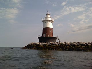
Greens Ledge Light is a historic lighthouse in the western Long Island Sound near Norwalk, Connecticut and Darien, Connecticut. It is one of 33 sparkplug lighthouses still in existence in the United States and remains an active aid to navigation. It sits in ten feet of water on the west end of Greens Ledge, a shallow underwater reef that runs a mile west of Sheffield Island and is roughly a mile south of the entrance to Five Mile River at Rowayton. Completed in 1902 by the Philadelphia Construction Company, the cast-iron structure is approximately 90 feet tall including roughly 15 feet of the submerged caisson. In 1933, more than 30,000 tons of rocks from the excavation of Radio City Music Hall were added to the riprap foundation. The light was added to the National Register of Historic Places as Greens Ledge Lighthouse on May 29, 1990.

Start Point lighthouse was built in 1836 to protect shipping off Start Point, Devon, England. Open to the public in summer months, it is owned and operated by Trinity House. It has been designated by English Heritage as a grade II listed building.
Yzerfontein, or Ysterfontein, is a small harbour town with about 1200 inhabitants on the west coast of South Africa about 90 km north of Cape Town. The name in Afrikaans means "Iron Fountain".The town started out when the farm 'Yzerfontein' was bought by the Katz-family in the 1930s. Then they started dividing the farm into plots. The main sources of income are tourism, mining and fishing.

Hellisøy Lighthouse is a coastal lighthouse in Fedje municipality in Vestland county, Norway. The lighthouse lies on the small island of Hellisøy, just off the southwest coast of the larger island of Fedje.

Booby Island Light is an active heritage-listed lighthouse located on Booby Island in the Shire of Torres, near the tip of Cape York Peninsula, west of Prince of Wales Island, within the Endeavour Strait, Queensland, Australia. It marks the western entrance to the navigation channel through the Torres Strait. It was the last of the major lights to be constructed along the Queensland coast.

Bustard Head Light is an active lighthouse located on the southeast tip of Bustard Head, a headland, about 20 kilometres (12 mi) northwest of Seventeen Seventy, in the Australian state of Queensland, within the Eurimbula National Park and locality of Eurimbula. Built in 1868, it is the second-oldest lightstation in the state, following Cape Moreton Light, and the first to be built in Queensland after its formation in 1859. It is also one of the first in Australia to be constructed using bolted prefabricated segments of cast iron, and one of only two such lighthouses in Queensland, the other being its sibling, Sandy Cape Light. It serves as the central relay for Dent Island Light, Pine Islet Light and Lady Elliot Island Light and as the radio check post for Cape Capricorn Light, Sandy Cape Light and Double Island Point Light.

Goods Island Light is an active lighthouse located on the highest point of Goods Island (Palilag), an island in the Torres Strait, belonging to Queensland, Australia. It serves as the rear light of the Goods Island Range, pointing out the entrance to Normanby Sound.

Cape Capricorn Light is an active heritage-listed lighthouse located on Cape Capricorn, a coastal headland on the northeast point of Curtis Island, in Gladstone Region, Central Queensland, Australia. The lighthouse, constructed in 1964, is the third at this site, following a timber frame lighthouse constructed in 1875 and a concrete lighthouse constructed around 1937. It was added to the Queensland Heritage Register on 31 August 2001.
Lady Elliot Island Light is an active lighthouse located on Lady Elliot Island, the southernmost coral cay of the Great Barrier Reef, 46 nautical miles north-east of Bundaberg, Queensland, Australia. The lighthouse is located on the western side of the island. It was the third lighthouse erected in Queensland after its formation in 1859 and the first in Australia to be constructed of a timber frame clad with iron plates. The original lighthouse was deactivated in 1995 and the light was replaced by a modern skeletal tower standing close to the original lighthouse.

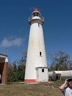
Cape Moreton Light, also listed as North Point Range Rear Light, is a heritage-listed active lighthouse located on Cape Moreton, a rocky headland located at the north eastern tip of Moreton Island, a large sand island on the eastern side of Moreton Bay, on the coast of South East Queensland, Australia. It marks the northern entrance to Moreton Bay and Brisbane and also serves as the rear light for the North Point Range. With its two distinctive red bands, it also serves as a daymark. It is the oldest lighthouse in Queensland, and the only one to be built by the New South Wales Government before the separation of Queensland, which took place in 1859. It is also the only lighthouse in Queensland to be built of stone.

Dent Island Light is an active lighthouse on Dent Island, a small island off the coast of Queensland, Australia, part of the Whitsunday Group of the Whitsunday Islands. Located on the southwest tip of the island, the light guides ships navigating the Whitsunday Passage, between Whitsunday Island and the islands to the west, and marks the Dent Island Passage.

North Reef Light is an active lighthouse located on North Reef, a 5.6 square kilometres (2.2 sq mi) planar reef, about 120 kilometres (75 mi) northeast of Gladstone, Queensland, Australia in the Capricorn and Bunker Group. The lighthouse was constructed on a migratory patch of sand inside a fringing coral reef, which over the years disappeared and reappeared, as sand was washed away and accumulated, and is now a vegetated sandy island. Its construction is unique, having a hollow concrete base that both gives it resistance to the shifting nature of the sandbar and serves as a freshwater tank. As such, it is considered one of the major achievement in Australian lighthouse construction. It is also notable in that due to the harsh conditions, only bachelors were allowed to serve as lighthouse keepers. At 24 metres (79 ft) it is also the tallest of Queensland's timber-framed iron clad lighthouses.
Eigerøy Lighthouse is a coastal lighthouse located at the small island of Midbrødøya which is located immediately west of the island of Eigerøya in Eigersund municipality in Rogaland county, Norway. It was established in 1854 and automated in 1989.
Bremstein Lighthouse is a coastal lighthouse in Vega Municipality in Nordland county, Norway. The lighthouse is located on the island of Geiterøya, about 22 kilometres (14 mi) west of the main island of Vega.

The Gibraltar South Mole Lighthouse is one of several lighthouses in Gibraltar, a British Overseas Territory at the south end of the Iberian Peninsula. Also known as the Gibraltar "A" Head Lighthouse, it has a cast-iron, skeletal tower which is painted black and features two galleries. The lighthouse remains operational and is positioned west of the Rock of Gibraltar, on the South Mole at Gibraltar Harbour. It is operated by the Gibraltar Port Authority.

The Portland Breakwater Lighthouse is a functioning lighthouse located at Portland Harbour, Isle of Portland, Dorset, England. It is situated on the southern end of the north-east breakwater.
Albardão Lighthouse is an active lighthouse located on a sandy strip known as Praia do Cassino, in the municipality of Santa Vitória do Palmar, Brazil on the South Atlantic Ocean; the lighthouse is one of the southernmost Brazilian lights.
Cabo Frio Lighthouse is an active lighthouse located on the southern point of the Ilha do Cabo Frio, called Focinho do Cabo, in the municipality of Arraial do Cabo, Brazil.
Ilha de Santana Lighthouse is an active lighthouse on the namesake island located at the east entrance of the Baía de São Marcos, Maranhão, Brazil

